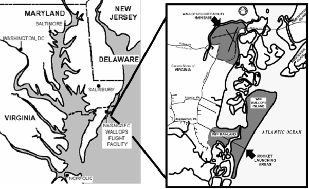
Figure 1: Location of Wallops Flight Facility
source: Excerpt from: http:www.absoluteastronomy.com.topics/Wallops_Flight_Facility
Geographic Summary
wallops Island
Virginia
Summary information for the Wallops site is a compilation of existing sources, selected documents, and Internet accessible data, which are referenced by section. The Geographic Summary is intended to provide a brief synopsis concentrating on Wallops Island, wetlands, and related features. It is not meant to be an in-depth treatise on the geography and background of the area.
Wallops Island National Refuge
Brief History of Wallops Island and Wallops Island National Refuge
Chincoteague National Wildlife Refuge
Enable Education, Commercial Development of Space, and Other Innovative Partnerships
Wallops History - Launching Excellence Through the Years
1945 — 1957: Pilotless Aircraft Research Station
1975 — 1981: Wallops Flight Center
Enabling Aerospace Technology and Facilitating the Commercial Development of Space
Enabling Education, Outreach, and Innovative Partnerships
Classification of Wetlands and Deepwater Habitats of the United States
Barrier Islands: Formation and Evolution
Barrier Island Morphology and Dynamics
Location of Wallops Island
source:
( http://encyclopedia2.thefreedictionary.com/Wallops+Island)
Virginia's offshore islands in the Atlantic include Chincoteague, Wallops, Cedar, Parramore, Hog, Cobb, and Smith. The boundaries of Virginia, including the Eastern Shore at the tip of the Delmarva Peninsula, total 1,356 mi (2,182 km), of which 112 mi (180 km) is general coastline. Wallops Island is 6 sq mi (15.5 sq km), located in Accomack County of Eastern Virginia off the Atlantic coast of the Delmarva Peninsula, and south of Chincoteaque Island.
Wallops Island National Refuge
Brief History of Wallops Island and Wallops Island National Refuge
Wallops Island National Wildlife Refuge was acquired by the US Fish and Wildlife Service as a transfer of property from the National Aeronautics and Space Administration (NASA). Having been considered underutilized land, NASA transferred the 373 acres of forest and marshland in 1975. During NASA's ownership, fields were leased for agricultural use. In addition, a small section was designated as a dump and sanitary landfill area. Prior to NASA's ownership, the land was owned by the Navy, Bureau of Yards and Docks. A small gravesite has been located on the property dating back to the 1880s.
Wallops Island proper, originally known as Kegotank Island, was granted to John Wallop by the Crown on April 29, 1692. Ownership was divided down through the years until the State of Virginia seized the property in 1876 and 1877 in lieu of unpaid taxes. From 1877, ownership was again divided and sub-divided until 1889 when it was held by various trustees for the Wallops Island Club. The Club was incorporated and assumed ownership in 1933 as the Wallops Island Association, Inc. Association members and their families spent the summers on the island fishing and swimming. The Association grazed sheep, cattle, and ponies on the area until the mid-forties. In 1947, the U.S. Navy began using the upper two-thirds of the island on a lease-rental basis for aviation ordinance testing. The N.A.C.A. (National Advisory Committee for Aeronautics), fore-runner of NASA, leased the lower 1,000 acres for rocket launching facilities. NASA acquired ownership
source:
US Fish and Wildlife Service
(http://www.fws.gov/refuges/profiles/index.cfm?id=51571)
Wallops Island National Refuge
The Wallops Island National Wildlife Refuge was created on July 10, 1975 when 373 acres of land were transferred to the U.S. Fish and Wildlife Service from the National Aeronautics and Space Administration (NASA). The refuge, comprised mainly of salt marsh and woodlands, is located east of Wattsville in Accomack County, Virginia and contains habitat for a variety of trust species, including upland- and wetland-dependent migratory birds. Additionally, the U.S. Fish and Wildlife Service has an agreement with NASA to use the NASA-owned portion of Wallops Island proper on a non-interference basis for research and management of declining wildlife in special need of protection. The agreement with NASA covers approximately 3,000 acres of Wallops Island proper and is primarily salt marsh. Wallops Island NWR and the agreement with NASA are administered by the staff at Chincoteague National Wildlife Refuge.
A sea-level fen, known as the Simoneston Bay sea-level fen, exists on and is protected by the refuge. Sea-level fens are nutrient-poor, maritime seepage wetlands, confined to a few sites with an unusual combination of environmental conditions for the mid-Atlantic. The fen is located just above the highest tide levels, at the base of a slope where abundant groundwater discharges. Only four occurrences are known in Virginia. The Wallops Island NWR was opened for the first time to public hunting in 2002 to reduce the affects of over-browsing by deer on refuge habitats and reduce the potential of deer collision with vehicles on the adjacent state highway 175 and neighboring flight facility.
Wallops Island Wildlife Refuge is managed by Chincoteague National Wildlife Refuge which is located the southern end of Assateague Island in Virginia.
The 373 acre portion of Wallops Island National Wildlife Refuge, which lies adjacent to Route 175, consists of saltwater marsh, woodland, grassland, and brush habitat. Waterfowl such as snow geese and black ducks take advantage of the refuge s extensive wetlands. Wading birds such as snowy egrets and black-crowned night herons utilize the tidal marshes to fish for food. Dunlin, dowitchers, and other shorebirds can be found feeding in the marsh at low tide. Northern harriers are a common sight flying low over the marsh, looking for a meal. Osprey and great horned owls use the refuge to nest and raise their young. A rare habitat, a sea-level fen, can also be found on the refuge. Sea-level fens are nutrient-poor, maritime seepage wetlands, confined to a few sites with an unusual combination of environmental conditions for the mid-Atlantic.
In the upland portions of the refuge, open areas are maintained for breeding American woodcock. Neotropical songbirds take advantage of the shelter and food that the forest can provide. Edge habitats, where two different habitats meet, are utilized by white-tailed deer, raccoons, and fox. The 3,000 acre portion of the refuge, in which the US Fish and Wildlife Service has a special management agreement with the land’s primary owner, NASA, is a barrier island. Its beaches are potential nesting sites for the threatened piping plover and other beach nesting bird.
Chincoteague National Wildlife Refuge
source:
US Fish & Wildlife Service, Chincoteague National Wildlife Refuge (http://www.fws.gov/northeast/chinco/)
Located on the southern end of Assateague Island in Virginia, the refuge was established in 1943 for the protection of migratory waterfowl habitat with emphasis on conserving the greater snow goose.
The refuges’ more than 14,000 acres of beach, maritime forest, saltmarsh, and freshwater marsh habitats are home to a spectacular variety of migratory birds, plants, and other animals.
The refuge is also one of the most visited refuges in the country and provides outstanding opportunities to connect with nature.
Chincoteague National Wildlife Refuge Overview
source:
Excerpt from: http://www.stateparks.com/chincoteague.htmls
Chincoteague NWR, located primarily on the Virginia side of Assateague Island, consists of more than 14,000 acres of beach, dunes, marsh, and maritime forest. Chincoteague Refuge, originally established in 1943 to provide habitat for migratory birds (with an emphasis on conserving greater snow geese), today provides habitat for waterfowl, wading birds, shorebirds, and song birds, as well as other species of wildlife and plants. Refuge staff manage this barrier island habitat to allow many species of wildlife to coexist, each establishing their own place in the environment. In fact, more than 320 species of birds are known to occur on the refuge. The refuge has been designated a Globally Important Bird Area, is part of the Western Hemisphere Shorebird Reserve Network and designated as one of the top ten birding Hotspots by the National Audubon Society.
Refuge management programs restore threatened and endangered species such as the Delmarva Peninsula fox squirrel, the bald eagle and the piping plover. More than 2,600 acres of man-made marshes, or moist soil management units, are managed for wintering waterfowl and shorebirds during migration. Unique residents of the island, the famous Chincoteague ponies, are housed in two areas on the refuge through a special agreement with the ponies' owners, the Chincoteague Volunteer Fire Company.
With approximately 1.4 million visits a year, Chincoteague NWR is one of the most visited refuges in the nation. Chincoteague Refuge provides visitors with extraordinary educational and recreational opportunities. In addition, a special partnership exists with the National Park Service which allows Assateague Island National Seashore to administer public activities on a five-mile portion of the refuge beach.
Wallops Flight Facility
Goddard Space Flight Center
source:
Excerpts and information are from NASA Wallops Flight Facility website (http://www.nasa.gov/centers/wallops/home/index.html)
Figure 1: Location of Wallops Flight Facility
source:
Excerpt from: http:www.absoluteastronomy.com.topics/Wallops_Flight_Facility
In October 2002, the NASA Administrator approved the Wallops Strategic Implementation Plan, Wallops Mission 2005 [PDF available online]. This plan provided the roadmap that has guided the priorities for Wallops personnel and facilities for more than five years.
Recently, Wallops assessed Mission 2005 against the current NASA and external environments and found that the overall Vision and Mission Elements remain valid and should remain the Wallops priorities for the future. Minor updates to specific focus areas have been made, building on recent accomplishments, incorporating support for NASA’s Vision for Space Exploration, and reflecting changes to environments. The Vision and three key Mission Elements are:
Wallops Flight Facility will be a national resource for enabling low-cost aerospace-based science and technology research.
- Enable scientific research through the development and deployment of low-cost, highly capable suborbital and orbital research carriers, project management, and mission services.
- Enable aerospace technology advances supporting NASA’s Science, Exploration Systems, and Aeronautics Mission Directorates, through advanced technology development, testing, and operational support.
- Enable education, the commercial development of space, and other innovative partnerships by leveraging Wallops’ unique capabilities and expertise to collaborate with industry, academia, and other government agencies.
Specific Wallops focuses for the future within these Mission Elements are described below.
- Manage and implement NASA’s suborbital science research carriers programs that provide sounding rockets, balloons, piloted aircraft, unmanned aerial systems, and future carriers to NASA researchers.
- Develop small, low-cost, & responsive orbital carriers and spacecraft supporting NASA science objectives.
- Evolve Wallops research carriers to support planetary research, such as planetary ballooning.
- Conduct Earth Science research, with a focus on global climate change and the unique dynamics of the coastal zone environment.
- Conduct science mission launch operations both locally and worldwide, leveraging the unique capabilities of the Wallops Research Range and Mobile Range.
- Partner with GSFC/Greenbelt and other NASA Centers to develop and launch small lunar robotic spacecraft.
- Serve as NASA’s premiere site for demonstrating critical Science, Exploration and Aeronautics technologies through use of the Wallops Research Range and in-house flight hardware development labs.
- Develop advanced technologies that support Wallops research carriers and mission operations, as well as other NASA priorities, in order to improve capabilities, increase safety, and lower costs.
Enable Education, Commercial Development of Space, and Other Innovative Partnerships
- Provide low-cost, hands-on training experiences using Wallops research carriers and Launch Range, supporting NASA priorities of workforce and science researcher development, and of exciting the next generation of scientists and engineers.
- Partner with regional and national educational organizations to pursue science and aerospace technology initiatives.
- Continue and expand NASA’s precedent-setting partnership with the Mid-Atlantic Regional Spaceport to facilitate growth of commercial space at Wallops through safe, low-cost, and responsive launch range services.
- Provide critical facilities and operational expertise to NASA and industry that enables commercial re-supply of the International Space Station.
- Be the organization-of-choice in providing flight projects and technology development for the Department of Defense and other government agencies through high-quality, low-cost, and responsive capabilities.
- Partner with regional government organizations to facilitate growth of the Wallops Research Park as an attraction and enabler for aerospace business, training, and research.
- Partner with Wallops tenant organizations through the Wallops Board of Directors to most efficiently carry out future planning and day-to-day activities.
At Wallops we like to say we enable science globally. Our sounding rockets, balloons, scientific aircraft and Education Flight Project Office facilitate study of the Earth, all regions of the atmosphere and the near-Earth and space environments.
From our beginning, we have taken a can-do approach to our work. We understand the importance of performing in a timely and cost-effective manner. We are proud to provide our customers with "quality, efficient, and cost effective" service. And we don't like red tape any more than our customers do - that's where our seasoned experts and long years of experience come into play.
The Wallops Flight Facility and our team of experts are equipped to conduct and assist with a wide variety of projects.
Wallops Flight Facility offers academic, government and commercial organizations state-of-the-art facilities and the expertise of our people.
With more than 50 years experience conducting suborbital projects, our staff are the experts. We are highly skilled in engineering, radar, project management, mobile campaigns and so much more. Our staff includes scientists, photographers, pilots, project managers and technicians. Whether operating our onsite instrumentation or traveling the world with our unique mobile facilities, we support researchers wherever the science takes them. Wallops' permanent facilities support NASA's Sounding Rocket and Balloon Programs. We also track NASA`s Space Shuttle missions using our communications, telemetry and radar facilities.Our launch range and research airport have access to virtually unrestricted airspace. The Wallops restricted area (R-6604) connects Wallops and the Mid-Atlantic Test Range warning area. An extended area can be coordinated with governing agencies to meet specific mission requirements. Because of our location, air traffic is minimal.
Wallops offers a wide array of launch vehicle trajectory options. In general, we can accommodate launch azimuths between 90 and 160 degrees depending on impact ranges. For most orbital vehicles, this translates into orbital inclinations between 38 and approximately 60 degrees. Trajectory options outside of these launch azimuths, including polar and sun-synchronous orbits, can be achieved by in-flight azimuth maneuvers.
We welcome researchers from academia, the private sector and government agencies. Two commercial launch pads provide support to commercial clients through the Virginia Space Flight Center that resides at Wallops and our research airport supports aircraft-launched rockets. We also support our many customers with a variety of services and facilities during the planning, execution and data analysis phases of their projects.
Wallops History - Launching Excellence Through the Years
Established in 1945 under NASA's predecessor, the National Advisory Committee for Aeronautics (NACA), Wallops is one of the oldest launch sites in the world. Our support of scientific research and orbital and suborbital payloads places us at the center of NASA's space and Earth sciences.
Built to conduct aeronautical research using rocket-propelled vehicles, Wallops launched its first rocket on July 4, 1945. Since then, we have fulfilled our mission with the launch of more than 14,000 rockets.
Over the years, our launch range has grown to include six launch pads, assembly facilities and state-of-the-art instrumentation. In addition, our mobile launch facilities enable our scientists and engineers to launch rockets around the world. The science dictates the launch site; we provide the expertise and instrumentation to launch, track, acquire data and recover the payload.
Wallops philosophy-then and now-is to provide a fast, low-cost and highly flexible response to meet the needs of America's aerospace technology community and science researchers. In addition to supporting NASA's bright stars-Project Mercury, Project Gemini, Project Apollo, and the Space Shuttle missions-we have a proud history of partnering with a diverse customer base to support and launch small projects that contribute significantly to Earth and space science.
1945 — 1957: Pilotless Aircraft Research Station
For our first 12 years, Wallops helped provide a foundation for aerodynamic and heat transfer research. Our high-speed aeronautical launch site used rockets to propel unmanned aircraft models. This facility enabled researchers to overcome the limited capabilities offered by the wind tunnels of the day.
1958 marked the birth of NASA and the civilian space program. At Wallops, researchers developed components of the human space program, such as capsule escape techniques, maximum pressure tests and recovery systems. Wallops led the way in range support for research in re-entry and life-support systems, Scout launch vehicles and mobile research projects.
1975 — 1981: Wallops Flight Center
While continuing to act as a launch site for suborbital and orbital vehicles, Wallops expanded its horizons to include Earth studies of ocean processes and used our research airport for runway surface and aircraft noise reduction studies.
1982 — 1996: Wallops Flight Facility
After consolidating with the Goddard Space Flight Center in 1982, Wallops Flight Facility became NASA's primary facility for suborbital programs. Our customer base diversified to include more commercial users for our research airport, tracking facilities and launch range. We continued to support academic and government programs and projects using sounding rockets, balloons and scientific aircraft to facilitate research of the Earth, all regions of the atmosphere and the near-Earth and space environment.
1997 — Mission 2005 Strategic Plan
Wallops continues to meet the needs of the U.S. aerospace program. Our Mission 2005 Strategic Plan, part of NASA's reorganization for the next century, will keep us in the mainstream of NASA's mission. Our can-do philosophy and ability to support NASA-sponsored, commercial and academic projects will help ensure our stability and vitality.
Recognized as a role model for pioneering productive and innovative government, industry and academic partnerships, Wallops will continue to serve as a key facility for operational test, integration and certification of NASA and commercial next-generation, low-cost orbital launch technologies. Under the Mission 2005 Plan, the following Mission Themes are identified, each containing several proposals.
Support the Earth and Space Science Enterprises by providing low-cost, highly capable suborbital and orbital carriers, mission management, and mission services to enable Earth and space science research.
Enabling Aerospace Technology and Facilitating the Commercial Development of Space
Support the Aerospace Technology and Human Exploration and Development of Space Enterprises by providing advanced aerospace technology development, testing, operational support, and facilitation of the commercial launch industry to enable frequent, safe, and low-cost access to space.
Enabling Education, Outreach, and Innovative Partnerships
Support other NASA goals and objectives by providing science and technology education and outreach programs including innovative partnerships with academia, other government agencies, and industry.
Wallops Fight Facility Education Outreach
Opening young minds to the wonders of Earth and space sciences is a NASA mission embraced by Wallops. Our long history of supporting education and our unique capabilities make Wallops an ideal laboratory for the development of aerospace education. Students of all ages benefit from Wallops programs and resources.
Weekly programs, hands-on exhibits and the opportunity to earn a "Space Ace" certificate and lithograph are educational activities hosted by the Wallops Visitor Center. Each program is designed to enable children to explore and learn about the technologies and information designed and used by NASA researchers and scientists.
In addition, Wallops reaches out with educational programs that bring science to the community. Our multi-talented personnel enjoy working with the community to further our mission of educating the public. We tailor our programs to the needs of our audience and often involve direct participation.
One Saturday a month, for example, we invite model rocketry enthusiasts to bring their own rockets and launch them at our launch range. Wallops personnel also participate, launching models of various rockets and explaining the payloads they carry in real life.
Wallops Command and Data Acquisition Station Source
source:
(http://eddn.usgs.gov/wallops.html; http://www.wcda.noaa.gov/)
The Wallops Command and Data Acquisition Station is responsible for ensuring scheduled data flow from NOAA satellites to designated user subsystems. It manages, operates, and maintains the station. The Station executes spacecraft commands and schedules. It acquires, maintains, and distributes a continuous flow of meteorological satellite data. Source: http://eddn.usgs.gov/wallops.html
The Wallops facility receives GOES DCS data from the GOES satellites. They then process the messages and make them available via the following methods:
1. Dial-In 3. DOMSAT
2. Telnet 4. LRGS
The Station develops and maintains records of Station performance, analyzes system failures, and establishes failure trends and implements corrective action. It prepares and issues reports on system anomalies, maintains station configuration control, and ensures operator and maintenance crew proficiency. The Station plans, designs, and implements system modifications. It tests and evaluates new systems and techniques. The Station assists in developing emergency procedures to safeguard spacecraft health and safety; and executes emergency plans independently in the event of a communications outage with the NESDIS Satellite Operations Control Center. It provides support for other activities requiring assistance.
Coastal Marshes
source:
NOAA, Chesapeake Bay Office (http://chesapeakebay.noaa.gov/coastalwetlands.aspx)
NOAA defines coastal wetlands as all wetlands in coastal watersheds—that is, watersheds that drain into the ocean or to an estuary or bay. Although you may think of tidal salt marshes when you hear "coastal wetlands,” there are many wetlands in coastal areas that are neither tidal nor salty. Some of the most common coastal wetlands are bottomland hardwood swamps, fresh marshes, salt marshes and submerged seagrass beds (which are in fact a type of wetland). Wetland habitats serve essential functions in the ecosystem, such as acting as water filters, providing flood and erosion control, and providing habitat for fish and wildlife.
Nationwide, coastal wetlands currently make up about 30% of the wetlands in the lower 48 states, or about 27 million acres. Since the 1700s, more than half of all the wetlands in the lower 48 states have been lost.
Coastal wetlands losses can be traced directly to population pressures and changes along the coast. Coastal populations have increased steadily since 1970 and currently more than half the population of the United States lives in coastal counties, at densities five times greater than those of non-coastal counties. Population growth and associated development place enormous pressures on existing natural resources. These pressures particularly affect wetlands, which are highly vulnerable to water-flow modification, pollution, and habitat fragmentation.
The rate of coastal wetland loss has declined over the past decades, particularly for tidal coastal wetlands such as salt marshes. Federal and state regulations governing the destruction of wetlands are partly responsible, as are community efforts to preserve existing coastal wetlands and restore damaged areas. In recent years, communities, organizations, state and federal governments, and volunteer citizens have begun to work together to save, restore, and create valuable wetland habitats, often in places that until recently were considered wastelands.
[The following section on coastal wetlands is from the State of Main Department of Environmental Protection, Bureau of Land & Water Control (http://www.maine.gov/dep/blwq/wetlands/coastal.htm)]
Coastal marshes are ‘grasslands’ periodically flooded by tides, primarily salt or brackish tidal water. These marshes are flooded by the tides at various intervals, ranging from once daily to a few times a year. When not flooded, the soils remain saturated near the surface at least during the high tide stage. The salinity due to ocean-derived salts creates a salt-stressed aquatic environment that prevents the establishment of most wetland plants. Plants adapted for life in salt water are called halophytes. Most halophytes actually grow best in fresh water, but are outcompeted by other plants there and forced to live in salt and brackish environments. In more saline areas, coastal marshes called salt marsh are represented by grasses and grasslike plant: smooth cordgrass, salt hay cordgrass, salt grass, salt marsh bulrush, glasswort, black grass, baltic rush, salt marsh sedge, and seaside arrow-grass. Further landward or upstream, brackish marshes dominated by narrow-leaved cattail are found. Seaside goldenrod, prairie cordgrass, and common reed also occur in these situations and along the upper borders of salt marshes. The most upstream coastal marshes are freshwater tidal marshes. They are strictly freshwater wetlands whose water levels fluctuate due to tidal action. Wild rice, cattails, and other freshwater species dominate these tidal marshes.
Classification of Wetlands and Deepwater Habitats of the United States
source:
USGS, Northern Prairie Pine Research Center (http://www.npwrc.usgs.gov/resource/wetlands/classwet/estuarin.htm)
Definition. The Estuarine System (Fig. 3) consists of deepwater tidal habitats and adjacent tidal wetlands that are usually semienclosed by land but have open, partly obstructed, or sporadic access to the open ocean, and in which ocean water is at least occasionally diluted by freshwater runoff from the land. The salinity may be periodically increased above that of the open ocean by evaporation. Along some low-energy coastlines there is appreciable dilution of sea water. Offshore areas with typical estuarine plants and animals, such as red mangroves (Rhizophora mangle) and eastern oysters (Crassostrea virginica), are also included in the Estuarine System.3
Limits. The Estuarine System extends (1) upstream and landward to where ocean-derived salts measure less than 0.5 ‰ during the period of average annual low flow; (2) to an imaginary line closing the mouth of a river, bay, or sound; and (3) to the seaward limit of wetland emergents, shrubs, or trees where they are not included in (2). The Estuarine System also includes offshore areas of continuously diluted sea water.
Description. The Estuarine System includes both estuaries and lagoons. It is more strongly influenced by its association with land than is the Marine System. In terms of wave action, estuaries are generally considered to be low-energy systems (Chapman 1977:2). Estuarine water regimes and water chemistry are affected by one or more of the following forces: oceanic tides, precipitation, freshwater runoff from land areas, evaporation, and wind. Estuarine salinities range from hyperhaline to oligohaline (Table 2). The salinity may be variable, as in hyperhaline lagoons (e.g., Laguna Madre, Texas) and most brackish estuaries (e.g., Chesapeake Bay, Virginia-Maryland); or it may be relatively stable, as in sheltered euhaline embayments (e.g., Chincoteague Bay, Maryland) or brackish embayments with partly obstructed access or small tidal range (e.g., Pamlico Sound, North Carolina). (For an extended discussion of estuaries and lagoons see Lauff 1967.)
- Subtidal. -- The substrate is continuously submerged.
- Intertidal. -- The substrate is exposed and flooded by tides; includes the associated splash zone.
Classes. Rock Bottom, Unconsolidated Bottom, Aquatic Bed, Reef, Streambed, Rocky Shore, Unconsolidated Shore, Emergent Wetland, Scrub-Shrub Wetland, and Forested Wetland.
___________________________________________________________________ The Coastal Zone Management Act of 1972 defines an estuary as "that part of a river or stream or other body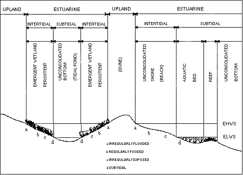
Fig. 3. Distinguishing features and examples of habitats in the Estuarine
System.
EHWS = extreme high water of spring tides; ELWS = extreme low water of spring tides.
of water having unimpaired connection with the open sea, where the sea-water is measurably diluted with
freshwater derived from land drainage." The Act further states that "the term includes estuary-type areas
of the Great Lakes." However, in the present system we do not consider areas of the Great Lakes as Estuarine.
Barrier Islands: Formation and Evolution
source:
Explanation abbreviated from NOAA Coastal Service Center (www.csc.noaa.gov)
Barrier islands are valuable natural resources that provide recreational areas, sensitive coastal habitats and ecosystems, and protect the marshes and coastal estuaries during storms. These islands characterize most of the Atlantic and Gulf Coasts and over the past 30 years have become densely developed, especially in New Jersey and Florida. As a result, erosion of these barrier island beaches can adversely affect the local, state, and regional interests that reside, recreate, or economically depend on the beaches. Thus, preservation and enhancement of barrier island beaches protects these interests and is the major impetus for beach nourishment.
Barrier islands are elongate accumulations of sand that are separated from the mainland by open water in the form of estuaries, bays, or lagoons. These primarily sandy islands have become in great demand for both residential and recreational development. Beaches on the seaward side of barrier islands are the principal location for beach nourishment. In order to properly manage these important natural resources it is important to understand the origin, dynamics, and probable future of barrier islands and their associated beaches.
Although barrier islands are quite extensive along the coasts of the United States, they can only be found along 15 percent of the world's existing coastlines. Most of the Atlantic and Gulf Coasts of the United States are comprised of barrier islands, and there are numerous such islands found along both the southeast and northern coasts of Alaska. The Pacific Coast, extending from Washington to California, is characterized by numerous short barrier spits that are elongate, primarily sand accumulations, generally connected to the mainland at a rocky headland.
The origin of barrier islands has been the subject of debate for more than a century. There are three prevailing theories that have been proposed attempting to explain their origins. The earliest theory is based upon waves concentrating on sand along the shallow water adjacent to a mainland shoreline. Waves transport sand landward until a sand bar is formed. As the crest of the sand bar reaches near sea level, the waves then begin to break over the top of a bar. This process continues over time until a fully-developed sand bar ultimately emerges, initially within the intertidal zone, and then eventually rising above the high tide. In the absence of major storms, opportunistic vegetation may develop on such a sand island. This vegetation traps additional sand, and builds small dunes that eventually become much larger formations. Such barrier island development has been observed at numerous locations along the Gulf Coast of Florida where islands of several kilometers or longer have developed in only a couple of decades.
Another theory of the origin of barrier islands is based on the premise that elongate sand spits were once connected to the adjacent mainland. These sand accumulations became isolated as the result of violent storms that breached the narrow and low-lying barriers, thereby forming islands. Such origins may be inferred from a few examples found along the Gulf Coast, where hurricanes routinely drive extremely high energy waves across such islands, resulting in multiple breaches.
A third theory of origin assumes that dunes lying along a low-lying coastline provide the core for the development of a barrier island during the period of rising sea level. As sea levels flooded these coastal areas, it is proposed that dunes rose to form elongate islands, which over time became separated from the mainland by the rising open water. This origin can neither be proven nor discounted, largely because there are simply no documented barrier islands that were formed assuming such a scenario. Nor are there any existing barrier islands that can be interpreted as having been formed as the result of the drowning of a coast.
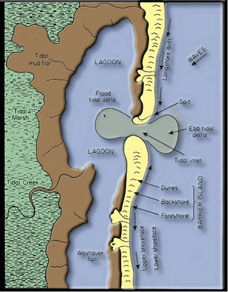
There are numerous distinct environments found within any particular barrier island. Although one or more of these environments may be present for any given barrier island, the overall scheme appears both consistent and predictable. Taken in sequential order, and beginning from open ocean to the outermost reaches of the back-barrier, these environments are as follows: nearshore, beach, dune, washover fan, marsh, tidal flat, and the adjacent estuary/lagoon.
The narrow zone immediately seaward of the shoreline is called the nearshore environment. This area generally extends from the shoreline across the zone of longshore sand bars and troughs. Usually longshore sand bars and troughs are present, but this is not always the case. The nearshore environment includes the normal surf zone where breaking waves occur. The number of longshore bars present depends upon the gradient, or slope, of the nearshore environment. In general, the more gentle the gradient, the more bars will be present. Hence, steep nearshore gradients tend to have few or no longshore bars. Longshore bars, when present, tend to persist throughout the entire year, but can move or change shape as seasons change or conditions vary.
The beach is the most familiar of the barrier island environments, and in many respects is the most important because it affords protection from wave attack to the landward upland environments (where development is typically located). The beach extends from the shoreline landward and often includes numerous changes in topography such as sand dunes, sea walls, or other man-made structures. A beach is typically divided into the seaward sloping foreshore and the nearly horizontal backshore.
The foreshore is considered to be that area where the last vestiges of waves rush up and back. This constitutes what is referred to as the swash zone, although such wave action can often cover an entire foreshore. This area is also the zone of the intertidal portion of the beach and may range in width depending upon slope or gradient.
The backshore is generally dry except during the occurrence of severe storms and their associated storm tides. Under normal conditions, the backshore is subjected only to wind action that blows the dry sand landward, creating dunes. Opportunistic dune or beach vegetation may occupy this portion of the beach.
Storms can cause a beach to erode, and can result in a uniformly seaward-sloping beach. This typically occurs during the winter months. During the calmer summer months, the beach gradually accumulates sediment as the result of currents, produced by low waves that return sand landward to the foreshore, or emergent, portion of the profile. If there is long-term erosion of a beach, it may be due to a variety of phenomena, including storms, high rates of sea level rise, interruptions in the longshore transport system along the beach, or inappropriate construction practices along the shoreline area that function to interrupt the longshore movement of sand.
The landward transport of sand causes the backshore environment to accumulate sand as dunes, where the growth of opportunistic vegetation on the backshore area traps blowing sand as it moves above the beach surface. As mounds of sand accumulate, vegetation continues to grow upward, forming substantial dunes. The principal factors involved in sand dune development are the presence and width of dry beach, and the abundance of sediment being supplied to the backshore areas. Dunes can provide excellent protection for the landward portion of a barrier island, and, when possible, their continued growth should be encouraged.
An increase in water level or large waves associated with storms can sometimes cause barrier islands to occasionally be washed over, forming what are referred to as washover fans. Low-lying islands generally permit widespread washover, whereas islands having dunes permit water to channel only in the lower spaces between dunes. Strong storm-induced currents over-washing a barrier island can carry abundant sand from the nearshore and beach inland. On a natural, undeveloped barrier island, this phenomenon is the primary method of naturally removing sand from a beach. Overtopping of barrier islands during storm events causes sand to accumulate into a fan-shaped feature on low barrier islands, where the washover or overtopping process can be quite significant, these fans coalesce to form washover aprons.
Individual fans may extend over hundreds to thousands of acres but are generally only 10-15 centimeters thick. It is not uncommon for washover fan deposits to accumulate in several layers, each representing a single storm. The washover deposits comprise the landward portion of a barrier island. Scientists have demonstrated that through the process of overwash, many barrier islands can actually conserve mass and will lose very little sediment during major storm events. Santa Rosa Island, located along the Florida panhandle, is a well documented example of this occurrence. In 1995, although struck almost directly by Hurricane Opal, very little sediment eroded from that barrier system.
The landward fringe of a barrier island is typically a wetland, generally a highly vegetated environment. In the lower latitudes this fringe can typically be populated by mangroves, while in the mid-to-higher latitudes this area is generally salt marsh. Wetlands develop along the intertidal portion of washover fans. They can provide excellent stabilization and protection from erosion for the landward shoreline of a barrier island.
The unvegetated intertidal zone on the protected landward side of the island represents the environment referred to as the tidal flat. These gently sloping island margins are typically covered with fine sediment and can be occupied by numerous bottom dwelling invertebrates. Such tidal flats are typically the distant portions of the washover fans. The width of the tidal flats is generally proportional to the tidal range of a given location.
Barrier Island Morphology and Dynamics
Barrier islands are acted upon by both wave and tide generated processes. Waves can range in both size and direction, and can cause beach erosion due to the fact that they can produce longshore currents flowing parallel to the shoreline. As tides rise and fall, waves interact differently with the nearshore profile, or the seaward portion of the barrier island. Tidal currents at inlets, separating barrier islands, typically produce sand bodies at the seaward mouth of the inlet or tidal channels. These sediment bodies may influence those processes that affect adjacent beaches. As the various processes of coastline interact with the barrier islands, extensive and yet relatively predictable changes occur. Such inlet shoals contain large reservoirs of sand, acting as sediment sinks, where large volumes of sand accumulate. These shoals are used as sand sources or borrow sites for beach nourishment.
Diagram showing the environments of a barrier island system
(from Blatt et al. 1980, Petrology of Sedimentary Rocks).
Climate: Rainfall and Temperature Patterns
The Indiana Dunes have a humid continental climate with strongly marked seasons. Winters are often cold, sometimes bitterly so. The transition from cold to hot weather can produce an active spring with thunderstorms and tornadoes. Oppressive humidity and high temperatures arrive in summer. Autumn has lower humidity than the other seasons, and mostly sunny skies.
The Indiana Dunes' location within the continent highly determines this cycle of climate. The air mass of the Gulf of Mexico is a major player in the climate. Southerly winds from the Gulf region transport warm, moisture laden air into the area. The warm moist air collides with continental polar air brought southward by the jet stream from central and western Canada. A third air mass source found in Indiana originates from the Pacific Ocean. Because of the orographic obstruction posed by the Rocky Mountains, however, this third source arrives less frequently in the state.
The effect of Lake Michigan on the climate of the Dunes is most important and this effect is most pronounced just inland from the Lake Michigan shore and diminishes rapidly with distance. Cold air passing over the warmer lake water induces precipitation in the lee of Lake Michigan in autumn and winter. As a result of this phenomenon, heavy winter precipitation, especially snowfall, can extend eastward from Gary inland to as far as Elkhart. Lake-related snowfall and cloudiness can extend to central Indiana in winter, driven by strong northwesterly winds. In the spring, daily maximum temperatures decrease northward in northern Indiana because of the cooling effect of the Lake. Average daily minimum temperatures in autumn are higher by the Dunes near the warmer lake surface than farther south.
A winter may be unusually cold or a summer cool if the influence of polar air is persistent. Similarly, a summer may be unusually warm or a winter mild if air of tropical origin predominates. The interaction between these two air masses of contrasting temperature, humidity, and density favors the development of low pressure centers that move generally eastward and frequently pass over or close to the state, resulting in abundant rainfall. These systems are least active in midsummer and during this season frequently pass north of the Dunes.
Weather changes occur every few days as surges of polar air move southward or tropical air northward. These changes are more frequent and pronounced in winter than in summer.
Wallops Island
Tidal Station
| Mean Range (ft) | Spring Range (ft) | Mean Tide Level (ft) | Latitude | Longitude |
| 3.6 | 4.4 | 1.9 | 37° 50.5' | 75° 28.7' |
Eastern Virginia Government Holdings
Chincoteague National Wildlife Refuge
| Landholdings | Acres |
| Assateague Island | 9,459 |
| Chincoteague Island | 550 |
| Morris Island | 427 |
| Assawoman Island | 1,434 |
| Metomkin Island | 174 |
| Cedar Island | 1,259 |
| Eastern Shore National Wildlife Refuge | 1,250 |
| Eastern Shore National Wildlife Refuge | 752 |
| Fisherman Island National Wildlife Refuge | 1,825 |
| Wallops Island National Wildlife Refuge | 3,376 (3000 owned by NASA) |
Geography
| Land area in square miles | Water area in square mile | Population density per square mile | |
| Accomack County, Virginia (VA) | 455 | 854.8 | 85 |
| Virginia | 40,767 | 1,063 | 178.8 |
Virginia Surface Water
Agriculture in Accomack County
| Average size of farms | 286 acres |
| Average value of agricultural products sold per farm | $3,43184 |
| Average value of crops sold per acre for harvested cropland | $ 677.36 |
| Value of nursery, greenhouse, floriculture, and sold as a percentage of the total market value of agricultural products sold | 6.25% |
| Value of livestock, poultry, and their products as a percentage of the total market value of agricultural products sold | 56.49% |
| Average total farm production expenses per farm | $253471 |
| Harvested cropland as a percentage of land in farms | 76.98% |
| Average market value of all machinery and equipment per farm | $110795 |
| The percentage of farms operated by a family or individual | 80.19% |
| Average age of principal farm operators | 55 years |
| Average number of cattle and calves per 100 acres of all land in farms | 0.67 |
| Corn for grain | 23851 harvested acres |
| All wheat for grain: | 12164 harvested acres |
| Upland cotton: | 1375 harvested acres |
| Soybeans for beans: | 34158 harvested acres |
| Vegetables: | 5591 harvested acres |
| Land in orchards: | 77 acres |