Geographic Summary
Trinity River, Texas
Summary information for the Trinity River site is a compilation of existing sources and selected documents, and Internet accessible data, which are referenced by section. The Geographic Summary is intended to provide a brief synopsis concentrating on Trinity River, wetlands, and related features. It is not meant to be an in-depth treatise on the geography and background of the area.
The Trinity River Authority of Texas
Information for this section is modified from the Trinity River Authority of Texas
website, http://www.trinityra.org, and used with permission.
Structure
The Trinity River Authority (TRA), a political subdivision of the State, was created by an Act of the 54th Legislature in 1955, and was charged with three functions:
We were charged with the following functions:
· Maintaining a Master Plan for Basin-wide development;
· Serving as a local sponsor for federal water projects;
· Providing services authorized by the Texas Legislature within the Authority's territory.
The organization is governed by a Board of Directors who are appointed by the Governor of Texas with the advice and consent of the Senate.
Mission
The Trinity River Authority of Texas (TRA) was created in 1955 by the 54th Legislature. TRA's statutory area includes all or part of 17 Texas counties within the Trinity River Basin.
When TRA was created by the state legislature, it was assigned three primary functions:
1. Creation and maintenance of a basin wide master plan for the Trinity River watershed.
2. Serve as a local sponsor for federal water projects.
3. Provide water and wastewater related services within the Trinity River Authority territory.
The Authority has successfully sponsored four US Army Corps of Engineers multiple-purpose water resource projects. Services currently provided by TRA include wastewater treatment, water treatment (potable water production), reservoir facilities, recreation facilities and functioning as a conduit for tax exempt financing for cities for water and wastewater treatment facilities; and for industry, provided services in the areas of air and/or water pollution control.
The Authority exists without the benefit of a direct tax base or state and federal appropriations. TRA provides services only to parties requesting service and only to the degree that service is actually delivered. If the revenues for an operating project exceed the expenditures, the surplus is returned to the customer entities served by that project in the form of cash or credit toward next year’s billings.
Discovery of Trinity River
General Alonzo de Leon, on May 19, 1690, while searching for the St. Louis outpost, discovered a river at a point near present day Midway, Texas. He named the river La Santisima de la Trinidad (which means in Spanish 'The Most Holy Trinity'). A custom of the time was to name prominent landmarks for religious feasts or holy days. The Trinity River was discovered two days before the Feast of the Most Holy Trinity.
Trinity River and Trinity River Basin
The Trinity River begins and ends within the state of Texas. The Trinity River Basin, the largest river basin in Texas, has more than 20% of the Texas’ population (approx. 21,000,000). This important tributary provides water to over half of the population of Texas and serves two major population centers: Dallas/Fort Worth in the north and Houston to the south. The Basin drains into the Galveston Bay and estuary system, one of the most productive ecosystems and commercial fisheries in the United States.
Trinity River Watershed
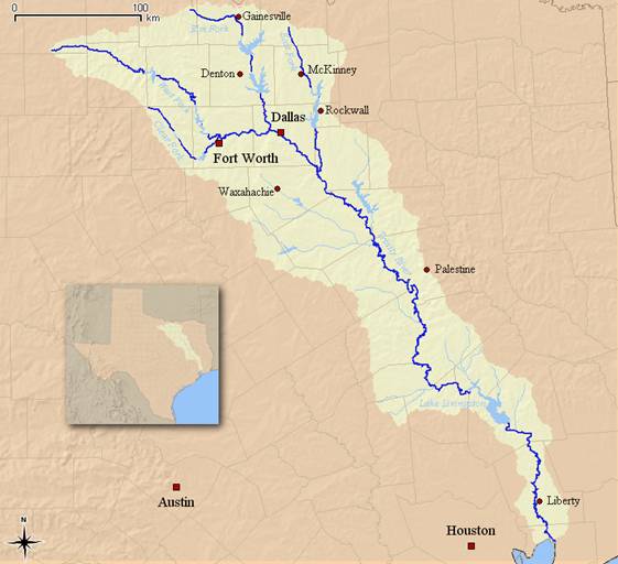
Source: USGS
The Trinity River originates from four forks: the East Fork in Grayson County, the Elm Fork in Montague County, the West Fork in Archer County, and the Clear Fork in Parker County. The Clear and Elm Forks join the West Fork in Fort Worth and Dallas respectively. The East Fork joins the Trinity River on the border of Ellis and Kaufman Counties just south of Dallas County. From there, it flows into Trinity Bay which is in the northernmost part of Galveston Bay near Anahuac, Texas.
The Trinity River basin lies in eastern Texas and has a total length of 360 miles. The total area drained by the Trinity River and its tributaries is 17,969 square miles, or approximately six percent of the state’s land area.
Dallas and Fort Worth, which were founded on the banks of the Trinity River in the mid-1800s, totally dominate the upper Trinity River basin. The Dallas/Fort Worth metroplex is the largest inland population center in the United States and has always had a profound effect on water quality.
In the early years of the Dallas/Fort Worth metropolitan area's development, it was not uncommon for major tributaries of the Trinity River to run dry. Today, because of the major lakes in the upper watershed and wastewater plant discharges, the Trinity River flows with more volume every year. In dry weather, it is not uncommon for the base flow of the Trinity River to be 95 percent treated wastewater. The Trinity River remains vulnerable and provides very little dilution. Because of these considerations, wastewater treatment plant operators process wastewater to the most advanced treatment standards in the nation. Approximately three and one-half million people are served by eight major regional wastewater treatment plants operated by the Trinity River Authority, Dallas, Fort Worth, Garland, and the North Texas Municipal Water District. Wastewater facilities operated by these entities release more than 500 million gallons per day of treated wastewater that has 98 percent of all conventional contaminants removed.
Chambers-Liberty Counties Navigation District
Source: Information from the Chambers-Liberty Counties
Navigation District: http://www.clcnd.com
The Chambers-Liberty Counties Navigation District stretches from the northern boundary of Liberty County to the southern boundary of Chambers County and varies from five to ten miles in width following the Trinity River. It comprises 255,649 acres in Chambers County and 185,375 acres in Liberty County. The original purpose of the district was to provide navigation, as it was intended to be the first leg of a barge channel to Dallas. The channel to Dallas never became a reality but the district now performs two major functions, navigation and raw water supply.
.
The Chambers-Liberty Counties Navigation District is a partner with the City of Houston, The Trinity River Authority and the U.S. Army Corps of Engineers for the Wallisville Saltwater Barrier that is constructed on the Trinity River two miles south of IH-10. This barrier was constructed to prevent saltwater intrusion upriver to the freshwater diversion points of the district and other entities that pump water from the river. The barrier is operated only during low river flow periods, which would allow saltwater to enter the river system from Trinity Bay. The barrier creates no impoundment beyond the natural surface of the river. The Barrier Office is staffed by the Galveston District of the U.S. Army Corps of Engineers.
The Trinity River
Source: U.S. Army Corps of Engineers, Galveston District,
http://www.swg.usace.army.mil/
Topography
The upper Trinity Basin has rolling topography and narrow stream channels. Soils in the region are deep to shallow clay, clay loam, and sandy loam that support elms, sycamores, willows, oaks, junipers, mesquites, and grasses. The middle and lower Trinity Basin is gently rolling to flat terrain with wide, shallow stream channels. Clay and sandy loams predominate and support water-tolerant hardwoods, conifers, and grasses.
The maximum elevation in the Upper Trinity River is 1,522 feet Mean Sea Level (MSL) in an area northwest of Fort Worth. From this area, which averages over 1,000 feet MSL, the land gradually slopes down to sea level along the southeasterly route of the river.
Physical Geography
Generally, stream flows in the Trinity River Basin follow the rainfall pattern of the area. In the North Central Texas area where the Trinity River originates, the annual average rainfall ranges from 27 inches in the west to about 33 inches in the east.
The mouth of the Trinity River is on Trinity Bay, an arm of Galveston Bay, the largest of the estuaries on the Gulf of Mexico between the Mississippi and Rio Grande Rivers. The Trinity River is the major source of fresh water inflow to Galveston Bay.
Taken in conjunction with land slopes and some other factors, the trends in precipitation and vegetation cause water runoff in the upper basin to be rapid but low in total volume. Runoff becomes progressively slower, but higher in total volume as one proceeds downstream. As a result, stream flows in the upper basin are more erratic and quite often zero. Most of the smaller streams in the basin cease to flow within a few days or weeks without rain, depending on the season and drainage area.
Several of the Trinity River’s tributaries, and the river itself below Dallas, have a base or dry weather flow of wastewater effluent discharged from wastewater treatment plants. As a result of geological and climatic conditions, the Trinity River Basin is divided into eight distinctively different physical regions. These regions are discernible by their vegetation, animal life and the uses to which they have been put by man.
- The North Central Prairie comprises approximately seven percent of the basin. This region is characterized by the lightest average rainfall of the entire watershed, stony and steeply sloping ridges made up of dense, shallow soils, grasslands and large sections of shrubs, mesquite, noncommercial cedars and other native vegetation. Primary agricultural activities are cattle and the cultivation of limited amounts of grains, hay and feed crops.
- The East and West Cross Timbers are soil groups formed during different periods of time, but are very similar in composition. The East Cross Timbers extend southward from the Red River through eastern Denton County and along the Dallas-Tarrant County boundary through Johnson County into Hill County.
- The West Cross Timbers is a much larger formation that extends south from the Red River through Clay, Montague, Jack, Wise, and Parker Counties on to the Colorado River. The soils contained in these formations are adapted to fruit and vegetable crops; and as a result, much of these areas have been converted to croplands of significant economic value despite the moderate rainfall. Other agricultural activities include dairy and beef cattle, sheep and goats raised on improved grazing land.
- The Grand Prairie region is a ten mile wide belt that separates the East and West Cross Timbers. It extends south from the Red River in an irregular band through Cooke, Montague, Wise, Denton, Tarrant, Parker, Hood and Johnson Counties. Sometimes called the Fort Worth Prairie, it has a primarily agricultural economy and largely rural population with no large cities except Fort Worth on its eastern boundary. The soil is predominantly limestone, but the terrain is generally rockier and steeper in the southern sections than in the gently rolling plains around Fort Worth. Generally treeless, this area is primarily used for livestock including beef and dairy cattle, sheep and poultry. The majority of the crops are grown for livestock feed with some cotton grown as a cash crop.
- The Blackland Prairies include the largest part (38 percent) of the Trinity River Basin. Its rich rolling prairies developed rapidly as a farming cotton producing area of Texas. The region extends from the Rio Grande gradually widening as it runs northeast to the Red River. Because of its early agricultural development the Blackland Prairie is still the most populated physical region in the state, containing within it and along its borders many of the state’s large and middle-sized cities, including Dallas. Primarily because of the early population concentrations, this belt has developed the most diversified manufacturing industry of the state. As a result of the fertile soil and adequate rainfall, agricultural activity abounds in this area with cotton serving as the principal crop.
- The East Texas Timberlands, which cover 25 percent of the Trinity River Basin, may be divided into two distinct sections. The Post Oak Savannah is a transitionary region between the Blackland Prairie on the west and the true East Texas Timberlands or “Piney Woods” on the east. This area has characteristics of both regions that can be seen in its native grasses and trees. As a result of poor drainage and low organic content, the soil is not suited for extensive cultivation, but many areas have been improved for cattle grazing.
- The East Texas Timberlands proper is the source of practically all of Texas’ large commercial timber production and is characterized by fairly heavy rain and wider-spread, better-developed forest areas than the Post Oak Savannah. This region was settled early in Texas history and is an older farming area of the state. The area’s soils and climate are adaptable to production of a variety of fruit and vegetable crops, but has experienced an increase in cattle production accompanied by the improvement of large sections of pasture land. In addition to lumber production, the area possesses large oil, clay, lignite and other mineral deposits with potential for development.
- The Coast Prairie and Marsh can be seen in Chambers County and a portion of the Liberty County area of the basin and characterized by heavy rainfall and alluvial soil.
The lower portion of the watershed is suited primarily for the production of rice and dense salt-tolerant grasses which provide excellent forage for cattle. The virtually featureless terrain of the area is poorly drained as a result of the dense soils and low elevations. The lush grass grown along the Coastal Prairie supports the densest cattle population in the state. This physical region, which includes Houston, has experienced the most extensive industrial development in Texas history since World War II.
The Bottomland of the Trinity River Basin consists of the flood plain areas adjacent to the tributaries and main stream and primarily consists of alluvial soil washed from the Blackland Prairies upstream. While this region contains the most potentially productive soil resources of the basin, and possibly the state, farming is a gamble due to frequent flooding; and as a result, generally not attempted. Land on higher river terraces is routinely farmed and is notable for large-scale production of corn, cotton, feed crops, livestock and commercial hardwoods. The primary use of the river bottom area is stock grazing. The largest part of the flood plain is covered in native grasses and hardwoods similar to those found in the East Texas Timberlands.
Water Quality
Non-point source pollution is the main reason that 40 percent of the nation’s assessed water bodies are unsafe for basic uses such as fishing or swimming. Non-point source pollution is caused by rainfall moving over and through the ground. As the runoff moves, it picks up and carries away natural and anthropogenic (human-made) pollutants, finally depositing them without getting treated into lakes, rivers, wetlands, and coastal waters, including underground sources of drinking water. These pollutants include: excess fertilizers, herbicides, and insecticides from agricultural lands and residential areas; oil, grease, and toxic chemicals from urban runoff and energy production; sediment from improperly managed construction sites, crop and forest lands, and eroding streambanks; bacteria and nutrients from livestock, pet wastes, and faulty septic systems.
In recent years, numerous studies have been carried out in the Upper Trinity River watersheds, particularly in the Dallas-Fort Worth area. These studies have been performed by agencies such as the Texas Commission on Environmental Quality (TCEQ), the Trinity River Authority (TRA), the North Central Texas Council of Governments (NCTCOG), universities and consultants. The following toxic chemicals have been documented to exceed water quality criteria levels in recent years: cadmium, chlordane, chromium, copper, dieldrin, endrin, heptachlor, lead, lindane, and PCB’s. Other toxics which have caused concern because of elevated levels in water and sediments include: aldrin, arsenic, DDT, hexachlorocyclopentadiene, mercury, selenium, silver and zinc.
The TCEQ has established criteria to determine if a water body falls short of meeting the state’s goal of maintaining its beneficial uses, such as drinking, fishing, and swimming. If it is determined that the designated uses of a water body are threatened or impaired, the affected water body is then placed on a list of impaired waters commonly referred to as the 303(d) list. Within the Upper Trinity River watersheds there are 26 impaired stream segments included in the 2002 EPA Approved 303(d) List. The majority of water quality impairments is due to high bacteria concentrations or depressed dissolved oxygen. These water quality impairments are a concern affecting both urban and rural areas.
The City of Wallisville
Excerpts from Texas State Historical Association
http://www.tsha.utexas.edu
Wallisville is on Interstate Highway 10 and the east side of the Trinity River in northern Chambers County. The town served as the county seat from 1858 to 1908. In 1825 Elisha Henry Roberts Wallis settled his family at Wallis Hill, a site east of the original townsite. The captured Mexican dictator Antonio López de Santa Anna was held prisoner at the Wallis family home on December 1, 1836, en route to Washington, D.C.
Solomon B. and Daniel B. Wallis, sons of the elder Wallis, had the townsite laid off in eighteen blocks in 1854. A post office was established there in 1857 with Albert G. van Pradelles as postmaster. The town was chosen over Anahuac as the county seat of the new Chambers County in 1858. Officials and merchants of both Wallisville and Liberty tried to attract the Texas and New Orleans Railroad in 1858, and the railroad opted for the Liberty route. Wallisville served as a principal steamboat landing on the Trinity River through 1877; there was also a brief resurgence in the Trinity trade during the 1890s.
The town's chief industries from the 1850s to the time of the 1915 hurricane were lumbering and shipbuilding. The earliest sawmill was Union Mills, established by Robert Kilgore and a partner named Clark. A number of mills flourished around the 1880s, and William E. Stephens established a substantial mill in 1897. The largest sawmill to be established was the C. R. Cummings Lumber Company, founded in 1899, when Charles R. Cummings and his brother, Jesse, consolidated their two mills from Liberty and Anahuac and moved to the west side of the Trinity River at Wallisville. The mill was destroyed in the 1915 hurricane. Another mill was owned and operated by John W. Cook.
Shipbuilding proved to be a steady industry at various times in the town's history. McLelland and Dunman turned out both steamboats and sailboats as early as 1855. Other shipyards followed, including one built by C. R. Cummings in 1901. The last shipbuilding enterprise came in the early 1940s, when Dunman Marine Services constructed the first steel boat to be built on the lower Trinity.
Arsonists destroyed the courthouse at Wallisville in 1875. A substantial brick courthouse was erected in 1886, and a distinctive jail and hanging tower followed in 1895. A Ladies' Aid Society raised funds to construct a Methodist church in 1895. Prior to that time Methodist, Baptist, Catholic, and Presbyterian services were held in various locations, including the 1869 schoolhouse. An active Methodist church still met in the schoolhouse in 1988. Although black congregations, both Methodists and Baptists, met after the Civil War, but only the Baptist church continued to operate in the late 1980s.
The Age, which Dan H. McGaryqv began publishing at Wallisville in 1897, was the first newspaper printed in Chambers County. Five other newspapers were published there during the first decade of the twentieth century. Other businesses developed: general merchandise stores, a saddle shop, a cotton gin, an ice cream parlor, a skating rink, a hotel, boarding houses, and a cobbler shop. A number of physicians and attorneys practiced in Wallisville. The Harvey Spur, a celebrated item on Southeast Texas ranges, was manufactured at Wallisville for many years.
The townsite suffered extensive damage during the 1875 hurricane and was almost completely destroyed in the 1915 hurricane. After the passage of a stock law in 1906, businessmen in Anahuac campaigned for an election to make their town the county seat. Chambers County voters approved the move in 1907. Citing numerous irregularities in the election, Wallisville residents unsuccessfully fought the move in the courts. The county records were moved to Anahuac in August 1908.
Efforts to construct a saltwater barrier or reservoir at Wallisville began in 1952, and a contract was signed in 1957 by the United States Army Corps of Engineers, the Trinity River Authority, the Chambers-Liberty Counties Navigation District, and the city of Houston to construct a reservoir. After the townsite was purchased by the federal government, work on the project began in 1966. Citing environmental concerns, federal judge Carl O. Bue, Jr., of Houston granted an injunction in 1974 that halted construction of the reservoir. A federal appeals court lifted the injunction in 1987, after the corps reduced the size of the proposed reservoir and made numerous other changes. Environmental groups continued their opposition to the project. The Wallisville Heritage Park was organized in 1979 and planned to rebuild the historic townsite. The Wallisville townsite was added to the National Register of Historic Places in Texas in 1982. The town had a population of 377 in 1990. In 2000 the population was 460.
Wallisville Area History
Source: U.S. Army Corps of Engineers, Galveston
District: http://www.swg.usace.army.mil/
There are 187 archaeological sites recorded on Wallisville Project lands dating from about 1700BC through the mid-twentieth century. Two areas are listed as National Historic Register Districts: Orcoquisac Archeological District and the Old Wallisville Townsite. In 1984, 19,700 acres of the Wallisville Project were determined eligible as a National Register District. One hundred sixty four of the archaeological sites are shell middens and 23 sites are from the presidio, mission, town site, and home sites scattered across the Project. No other area along the Texas coast has been so thoroughly inventoried for existing archaeological sites. The shell midden sites primarily consist of rangia clam and/or oyster shells discarded by the early Native Americans who used the clams and oysters as staple food sources. Akokisa, Arkikosa, and Orcoquiza are alternate spellings of the names used for these Native American peoples. In 1756 AD the Spanish established Presidio San Luis Agustin de Ahumada del Orcoquisac and Mission Nuestra Senora de la Luz to help prevent French settlement and trading with the Orcoquiza and Bidai who were living in the area at that time. The Presidio was garrisoned with Spanish troops through 1771. It was officially abandoned in 1772. The missionaries were the last persons to leave the site.
The Wallisville area began to be settled by illegal immigrants from the United States in 1810. Legal immigration began with Elisha Henry Robert Wallis and family in 1824. The Wallis’s were part of Stephen F. Austin’s “Old 100” group of settlers. Elisha HR Wallis’s sons Daniel and Solomon were instrumental in the founding of the town of Wallisville in the year 1854. Trading, ranching, and logging were major activities of the settlers. Steamer traffic began in 1838 with the vessel, the Branch T. Archer and by 1893 at least 100 steam powered vessels plied the Trinity. From 1858 – 1908 Wallisville served as county seat for Chambers County. A thriving community, Wallisville’s businesses included sawmills, stores, the first newspaper in Chambers County, Baptist, Catholic, Methodist, and Presbyterian churches, schools, a saddle shop, a cotton gin, a hotel and boarding houses, physicians and attorneys. The town suffered major damage by the 1875 hurricane and was almost completely destroyed by the hurricane of 1915.
Wallisville Lake Project
Source: U.S. Army Corps of Engineers, Galveston
District: http://www.swg.usace.army.mil/
History of the Project
Efforts to construct a saltwater barrier and/or reservoir at Wallisville on the Trinity River began in 1952. Congress first authorized the construction of the Project through the River and Harbor Act of October 22, 1962. The government purchased the property and construction began in 1966. At this point, the Project would have been a 19,700 acre reservoir with surface elevation of 4 feet above mean sea level. A contract for water supply, salinity control, and recreation was signed between the US Army Corps of Engineers, the Trinity River Authority, the Chambers-Liberty Counties Navigation District, and the City of Houston and was approved by the Secretary of the Army on February 2, 1968. In September 1971, a lawsuit was filed by the Sierra Club in US District Court against the construction of the Project. At approximately 72% complete, the construction was halted in 1973 by a summary judgment decision of the Court. Between 1973 and 1987 the Project was revised and reevaluated. In May of 1987 the Fifth Circuit Court of Appeals dismissed the lawsuit in favor of the government and lifted the injunction against continuing construction. Then in November of 1989 a pair of nesting bald eagles was discovered near Miller Lake and the Project was reevaluated again. It was this reevaluation that gave rise to the Project as it stands today:
· a set of levees along the east and west banks of the Trinity in conjunction with the dam across the Trinity;
· the navigation lock and engineered navigation channel;
· the gated control structure on main stem of the Trinity;
· Structure A in the Cut-Off near Pickett’s Bayou;
· Structure B at the head of Lost River; and
· the parks and recreation areas.
The original 39,000 feet long concrete dam structure across the marsh was abandoned after it was breached in 2001 to allow for normal water flows of the Old River and several smaller streams and bayous. Cedar Hill Park was completed in October 2000 and is leased to Chambers County for operation and maintenance. The JJ Mayes Wildlife Trace was opened to the public in May 2003. Hugo Point Park was opened in August 2003 and is leased to Chambers County for operation and maintenance.
Construction
The Wallisville lock and dam is a unique structure among Corps of Engineers projects. Instead of the typical concrete reservoir-gate system, it is four wooden/steel gates standing above the water line, with no reservoir behind. The navigational lock consists of two sets of paired wood and steel gates. Each gate weighs approximately 83 tons, swings a 45 feet radius, and stands 25 feet tall. The gates are mounted using a pintle type anchor and hinge support. The gates are moved by a combination of Rueland electric motors, supplying power to Faulk speed gear reducers.
The motors operate on 480 volts, and produce 1.25 HP @ 300 RPM’s at slow speed and 5 HP @ 1,200 RPM’s during high speed operation. The gates are operated via control panels inside a control house, at the location of the pair of gates being operated. The area between the two sets of gates makes up the navigational lock chamber. The lock chamber is approximately 1,500 feet long and is 84 feet wide. The navigation channel depth averages approximately 14 feet deep at the low mean tide level. The saltwater barrier dam consists of a concrete structure with 4 steel tainter gates and their operating equipment sitting on top of the dam structure. The dam, when in operation with the navigational lock, seals the river off completely to prevent saltwater from intruding upstream into fresh water. The entire concrete dam structure, including the bridge, is 224 feet wide in the river and stretches 324 feet long. Each steel tainter gate has a 24 feet radius from the center of the trunion girder to the face of the gate. The trunion girder anchors the gate to the concrete structure. Each gate is 46 feet wide and stands 16 feet tall when sitting on the bottom of the channel. When on the bottom of the channel the gate protrudes 4 feet above the low mean tide level. The river channel is 12 feet deep at low mean tide level Each gate is supported by 4- 1 ½” stainless steel cables, two on each side, on the face of the gate. The cables are wound up by parallel shaft gears sitting on the upper structure of the dam 25 feet above the gates where they are operated via control panels. Rueland electric motors are used with 460 volts, to operate the machinery. Each motor produces 3 HP @ 900 RPM’s. The motors turn Lufkin gear reducers which have a reduction ratio of 1501:1 in order to turn the parallel shaft connected to the cable.
Purpose
The Wallisville Lake Project was originally authorized by Congress for five purposes:
1. navigation,
2. salinity control,
3. water supply,
4. fish and wildlife enhancement, and
5. recreation.
These purposes are still current today even though the Project is much different now than originally conceived. The Trinity River is navigable by pleasure boats from its mouth and north as far as Liberty, Texas. The Galveston Bay area shrimp fleet utilizes the Trinity as safe harbor during major hurricane events. The Wallisville Lock and Dam and Structure A provide for salinity control by opening and closing depending on tides, river flows, winds, and drought conditions. The Trinity River is a major source of water for the Houston metro area, for several smaller communities, and for irrigation canal districts in both Liberty and Chambers Counties. Unlike most other Corps projects, Wallisville has no impounded reservoir so the bottomland forests, grasslands, streams, marshes, swamps, and pools are still preserved as natural habitats for a wide variety of fish and aquatic animals. Depending on tides and fish movements, anglers could find marine species one day and fresh species the next. Birds, such as colonial waders, shore birds, waterfowl, songbirds, and raptors call Wallisville home for breeding, wintering, or temporary residence during migration. Mammals large and small find forage and shelter in the grasslands, forests, and swamps, as does the American alligator.
Recreation Development
The Wallisville Lake Project has two parks and two recreation areas. Cedar Hill Park opened in 2000, Hugo Point Park opened in 2003. Both parks are managed by Chambers County by a lease agreement. Trinity River Island Recreation Area first opened to the public in 1999, but was not completed until 2003. Operated by the US Army Corps of Engineers, TRIRA is an island between the main stem of the Trinity River and the engineered navigation channel. JJ Mayes Wildlife Trace is a four mile all weather road atop the levee along the west bank of the Trinity River. Opened in 2003, the Trace offers an opportunity for a close-up view of the marshes and river bank habitats and many of the wildlife species living within the boundaries of the Wallisville Project.
Agriculture
Excerpts from Galveston Bay Information Center, http://gbic.tamug.edu and
Texas A&M University System Agricultural Research and Extension Center,
Beaumont, Texas, http://beaumont.tamu.edu
The wetlands of the lower Trinity River area are largely suited for rice farming and rice farming alone. Plenty of rice land has been retired, however-the Texas rice farming industry has been hit by several obstacles. Government over-regulation, increasing costs, and lack of access to prime foreign rice markets in Iran, Iraq and Cuba have caused the amount of land in Texas given over to rice farming to fall from a peak of 600,000 acres in 1972 to less than 200,000 acres in 2004.
While this is tragic news for the local agricultural economy, there are several benefits. More water is available for municipal use in Houston and Galveston. There is also more land is available for wetlands, as rice farming land, once retired, is virtually useless for any other productive agricultural endeavor.