Township, Range, and
Section
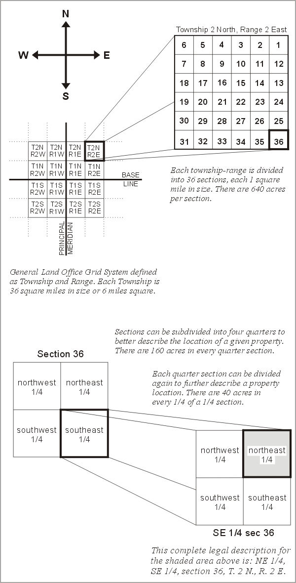 In 1812, the U.S. Government formed the General Land Office (renamed the
Bureau of Land Management in 1946) to create a standardized system to more
accurately define a given U.S. location. This system was initiated in
response to the acquisition of large tracts of land, like the Louisiana
Purchase, during the 1800s. The system developed by the Government Land
Office is called the [General Land Office Grid System] and is used in
states west of Ohio [as well as part of Ohio]. The system divides land
into 36-square-mile units called townships. Each township has a township
and range designation [shown in red print as, for example, T. 20 N., or R.
4 E. along the edge of the 1:24,000 topographic map] to define its
36-square-mile area. Township is numbered north and south from a selected
parallel of latitude called a base line, and range is numbered west or
east of a selected meridian of longitude called a principal meridian.
In 1812, the U.S. Government formed the General Land Office (renamed the
Bureau of Land Management in 1946) to create a standardized system to more
accurately define a given U.S. location. This system was initiated in
response to the acquisition of large tracts of land, like the Louisiana
Purchase, during the 1800s. The system developed by the Government Land
Office is called the [General Land Office Grid System] and is used in
states west of Ohio [as well as part of Ohio]. The system divides land
into 36-square-mile units called townships. Each township has a township
and range designation [shown in red print as, for example, T. 20 N., or R.
4 E. along the edge of the 1:24,000 topographic map] to define its
36-square-mile area. Township is numbered north and south from a selected
parallel of latitude called a base line, and range is numbered west or
east of a selected meridian of longitude called a principal meridian.
Townships are sub-divided into 36 1-by-1-mile parcels called sections.
Sections are numbered from 1 to 36 for identification. Sections are broken
into quarters, which are further quartered to describe a property
location. The figure [to the right] shows the numbering systems for
township-range, sections, and quarter sections.
The [land] office grid system is used for legal land descriptions.... [In
Washington, for example, the west end of Grand Coulee Dam is in the
SW1/4NW1/4 sec. 1, T. 28 N., R. 30 E. The Willamette principal meridian
divides west and east ranges in Washington. It runs north–south from
near Blaine, just west of Woodland, and on south. The baseline, which
divides north and south townships, is actually in Oregon; it runs east–west
through Portland. It is called the Willamette base line.]
 In 1812, the U.S. Government formed the General Land Office (renamed the
Bureau of Land Management in 1946) to create a standardized system to more
accurately define a given U.S. location. This system was initiated in
response to the acquisition of large tracts of land, like the Louisiana
Purchase, during the 1800s. The system developed by the Government Land
Office is called the [General Land Office Grid System] and is used in
states west of Ohio [as well as part of Ohio]. The system divides land
into 36-square-mile units called townships. Each township has a township
and range designation [shown in red print as, for example, T. 20 N., or R.
4 E. along the edge of the 1:24,000 topographic map] to define its
36-square-mile area. Township is numbered north and south from a selected
parallel of latitude called a base line, and range is numbered west or
east of a selected meridian of longitude called a principal meridian.
In 1812, the U.S. Government formed the General Land Office (renamed the
Bureau of Land Management in 1946) to create a standardized system to more
accurately define a given U.S. location. This system was initiated in
response to the acquisition of large tracts of land, like the Louisiana
Purchase, during the 1800s. The system developed by the Government Land
Office is called the [General Land Office Grid System] and is used in
states west of Ohio [as well as part of Ohio]. The system divides land
into 36-square-mile units called townships. Each township has a township
and range designation [shown in red print as, for example, T. 20 N., or R.
4 E. along the edge of the 1:24,000 topographic map] to define its
36-square-mile area. Township is numbered north and south from a selected
parallel of latitude called a base line, and range is numbered west or
east of a selected meridian of longitude called a principal meridian.