Scale, Scale Conversion
SCALE
Maps represent areas and features, but not at their actual size. A large scale map covers a small area while a small scale map covers a large area. The reduction of an area is known as the scale of a map. To effectively use maps you need to convert measurements from map units to ground units.
The relationship between ground and map distance can be expressed by either a linear or aerial measurement. Linear measurement is expressed in three ways: as a word statement, as a graphic scale, and as a representative fraction (RF). Areal measurement most often is expressed by a graphic scale such as a circle or square of a proportionate size.
Examples:
Word Statement:
A word statement is a descriptive scale and usually is expressed in different units
One inch is equal to three miles
(1" = 3 miles)
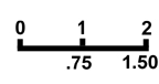
Graphic Scale:
The simplest graphic scale is a bar scale. When a map is enlarged or reduced, the bar scale changes size in direct proportion to the map.
inches on the map
miles on the ground
Representative Fraction (RF):
Scale can be expressed as a ratio or representative fraction (RF). Measurement units must be the same for the numerator and the denominator. The numerator is always one and represents the map distance; the denominator represents the ground distance. The advantage of identical units is that map measurements may be made in whatever unit you choose.
An RF of 1:24000 means that:
One inch on the map is equal to 24000 inches on the surface of the earth.
One centimeter on the map is equal to 24000 centimeters on the surface of the earth.
SCALE CONVERSIONS
Enlarging or reducing a map is necessary for easy comparison with another map. Enlarging a map by 200% means to make the enlarged map two times bigger than the original map. Reducing a 1:30,00 scale map to 50% of its orginial size changes the RF scale to 1:60,000.
Converting a word statement to a representative fraction:
Ratio of map distance (numerator) to ground distance (denominator)
1" to 3 miles
| 1" | 1" | 1 |
| 3 mi. | 3 x 63,360 | 190,080 |
5" to 8 miles
| 5" | 5" | 5 | 5 / 5 | 1 |
| 8 mi. | 8 x 63,360 | 506,880 | 506,880 / 5 | 101,376 |
.2" to 5 miles
| .2" | .2" | .2 | .2 / .2 | 1 |
| 5 mi. | 5 x 63,360 | 316,800 | 316,800 / .2 | 1,584,000 |
Worked examples:
1. How many inches to the mile when the RF = 1:24,000?
| 2.64 |
| 24,000 / 63,360.00 |
2. How many miles to the inch when the RF = 1:24,000?
.3798 |
| 63,360 / 24,000.0000 |
3. How many cm to the km. when the RF = 24,000?
4.17 |
| 24,000 /100,000.00 |
4. How many km to the cm. when the RF = 24,000?
.24 |
| 100,000 / 24,000.00 |
| RF | Inches to Miles |
Miles to Inches |
Cm to Km | Km to Cm |
| 1:1,980 | 32 | .03125 | 50.50 | .0198 |
| 1:3,960 | 16 | .0625 | 25.25 | .0396 |
| 1:7,920 | 8 | .125 | 12.626 | .0792 |
| 1:15,840 | 4 | .250 | 6.313 | .1584 |
| 1:31,680 | 2 | .5 | 3.156 | .3168 |
| 1:63,360 | 1 | 1.0 | 1.578 | .6336 |
| 1:126,720 | .5 | 2.0 | .789 | 1.2672 |
| 1:253,440 | .25 | 4.0 | .3946 | 2.5344 |
| 1:506,880 | .125 | 8.0 | .197 | 5.0688 |
| 1:1,013,760 | .0625 | 16.0 | .0986 | 10.1376 |
| Linear Measure | Square Measure | |||
| 1 inch | .0833 foot | 144 sq. in | 1 sq ft | |
| 12 inches | 1 link | 9 sq ft. | 1 sq yard | |
| 208 feet | 1 acre | 43560 sq ft. | 1 acre | |
| 5280 feet | 1 mile | 4840 sq. yds | 1 acre | |
| 1760 yards | 1 mile | 640 acres | 1 sq mile | |
| 63360 inches | 1 mile | |||
| Metric Measure | English Linear Measure |
Conversion |
| centimeter (cm) | inch (in) | 1 cm = 0.3937 in. 1 in. = 2.54 cm |
| meter (m) | foot (ft) | 1 m = 3.28 ft 1 ft = 0.305 m |
| kilometer (km) | mile (mi) | 1 km = 0.621 mi 1 mi = 1.61 km |
| Area Measurement | ||
| sq. centimeter (cm2) | sq. inch (sq in.) | 1 cm2 = 0.155 sq in 1 sq in. = 6.4516 cm2 |
| sq. meter (m2) | sq. foot (sq ft) | 1 m2 = 10.764 sq ft 1 sq ft = 0.0929 m2 |
| sq. kilometer (km2) | sq mile (m2) | 1 km2 = 0.3861 sq mi 1 sq mi = 2.59 km2 |
| hectare (ha) | acre | 1 ha = 10,000 m2 = 2.471 acre 1 acre = 43,560 sq ft = 0.4047 ha |
* Scale examples, scale conversion, index of common map and ground distance units are modified from Map Use by Phillip Muehrcke and from The Language of Maps by Phil Gersmehl.
REFERENCES
Scale and dot grids:
Avery, Thomas E. and Grydon L. Berlin. 1992. Fundamentals of Remote Sensing and Airphoto Interpretation, fifth edition. New York: Macmillian Publishing Company.
Gersmehl, Phil. 1991, 1996. The Language of Maps, Pathway in Geography series. Indiana, Pennsylvania: National Council for Geographic Education.
Muehrcke, Phillip C. 1986. Map Use: Reading, Analysis, and Interpretation, second edition. Madison, Wisconsin: JP Publications.
Paine, David P. 1981. Aerial Photography and Image Interpretation for Resource Management. New York: John Wiley & Sons.