Geographic Summary
Red River
Shreveport, Louisiana
Summary information for the Red River site is a compilation of existing sources and selected documents, Internet accessible data, which are referenced by section. The Geographic Summary is intended to provide a brief synopsis concentrating on Red River floodplains and related features. It is not meant to be an in-depth treatise on the geography and background of the area.
1. Red River Education and Research Park and the Red River Watershed
Management Program …….……………….……………………………………… 2.2
Red River Education and Research Park…………………………………..….... 2.3
Red River Watershed Management Program ……………………………..…..... 2.3
2. Article: River data…………………...................................................................... 2.5
3. The Great Raft: Brief Chronology…………………............................................ 2.9
4. River Channel Morphology…………….……………………………………...... 2.10
Meandering Channels……………………………………….……………..…... 2.10
Floodplains and Levees………………….……………………………… 2.11
5. River Stage: Current …………………………………………………………..... 2.12
6. River Stage: Historical Composite ……………………………………………... 2.13
The Red River Education and Research Park and
The Red River Watershed Management Institute
By Gary M. Hanson, Director, Red River Watershed Management Institute
Louisiana State University-Shreveport
In 1833 Captain Henry Miller Shreve began clearing the Great Raft, an accumulation of logs, sand and debris, which clogged the Red River channel for 200 miles beginning north of Alexandria, Louisiana. The phenomenon of the raft was a result of the river channel cutting through alluvial soil deposits. This left riverbanks, which eroded easily and collapsed into the river along with vegetation causing undesirable backwater swamps, frequent spring flooding, and extremely difficult passage. Before the raft was cleared, only pirogues, canoes, and keel boats could thread their way through the channel. In 1836 Captain Shreve organized Shreve Town (which became Shreveport). The establishment of the easily navigable channel and subsequent drainage of the backwater swamps led to a period of rapid expansion the area, centered on commerce along the river. The backwater swamps were transformed into a series of flourishing plantations such as Sunflower Plantation, which included the area now occupied by C. Bickham Dickson Park.
Between 1880 and 1898, several steamboat lines operated on the river, making frequent stops along the way. One of these stops was Sunflower Plantation. Shipwrecks were numerous, and records show a sinking at Devil’s Elbow—a bend in the river near the C. Bickham Dickson Park site. The steamboat era drew to a close in the early twentieth century with the gradual dominance of railroad transportation. Records show Sunflower Plantation still listed as a landing place for the Red River Line in the early 1900s. Part of the plantation was Sunflower Point, a peninsula bordered on three sides by the Red River as it curved back on itself. In the natural process by which rivers change course, meanders are frequently cut off in favor of a more direct route. This occurred at Sunflower Point in 1945 when the Red River finally cut through the remaining neck of land and established a new channel alignment where it is today. The remaining river meander silted in at its junctures with the new channel and became the oxbow lake known as Old River Lake.
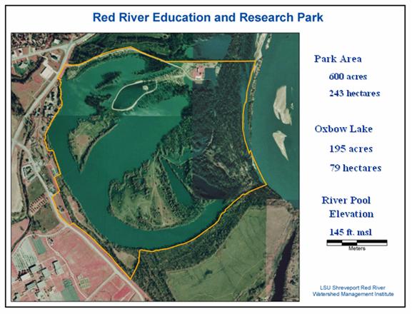
Red River Education and Research Park
In 1981 the city of Shreveport developed the C. Bickham-Dickson Park on land surrounding Old River Lake. Recognizing the site’s unique characteristics and anxious to take advantage of its proximity to the campus, Louisiana State University Shreveport (LSUS), and the City of Shreveport executed a Cooperative Endeavor Agreement that created Red River Education and Research Park (RRERP) in the year 2000. The RRERP is defined as the activities of:
- The development of C. Bickham Dickson Park and its facilities as a center for natural resource management, and
- Furthering the study of the Red River basin by development of educational and research activities in C. Bickham Dickson Park and other locations.
This 585-acre park, that lies along Red River and abuts LSUS, is an ideal location for sport fishermen, naturalists, and those who enjoy outdoor recreation. The park is the site of environmental research led by LSUS faculty in collaboration with other universities, business and industry, and city, state, and federal agencies. It also offers splendid opportunities for students and the general public to study the river, its natural oxbow lake, its bottom-land hardwood floodplain and its watershed.
Red River Watershed Management Institute
Research and education activities are coordinated by the Red River Watershed Management Institute (RRWMI) at LSU Shreveport. A major purpose of the Red River Watershed Management Institute (RRWMI), an LSU system institute, is to help improve and ensure good water quality conditions within the Red River Watershed (initially concentrating on that portion of the Watershed within the state of Louisiana) by bringing to bear the academic, technological and scientific tools this university can now provide in the field of watershed management. At the park, the Institute has overseen the development of water quality monitoring stations, including a floating profiling system (LTEMP), a deep monitoring well, inventory of the parks flora and fauna and biological inventories, as well as bird and bat habitat enhancement projects. The “Bat Condos” project is a 50-foot long artificial bat cave constructed out of large tires recycled from local coal mining operations. On campus at LSUS, the Institute has developed (jointly with the LSU Health Sciences Center) a Watershed Environmental Lab. The lab includes state-of-the-art equipment capable of analyzing all types of media (water, soil, sediment, plants and animal tissue) collected in the park and throughout the Red River watershed. The Institute has also developed and implemented programs to offer continuing education opportunities for K through 12 teachers and students.
River of data A unique wetland resource in northwest Louisiana has become a cutting-edge outdoor "laboratory"
By Ashley Sexton-Gordon (2004)
Reprinted with permission from Louisiana Research Magazine, Baton Rouge, Louisiana. www.LouisianaResearch.com
On a clear morning, Gary Hanson sees the sunlight reflect in the calm sheet of water topping the oxbow lake at the Red River Education & Research Park in Shreveport. He walks out onto the pier. Hundreds of white pelicans have relocated to this migratory habitat before departing later in the month for the Gulf of Mexico.
Hanson notes the lake's water level has risen a bit since last week, which means the Red River's waters are flowing in. Within a few hours, automated monitoring stations on the lake will have amassed volumes of water quality data and sampled this new flux of water. Hanson is eager to see what changes have occurred in the lake. So he heads across the roadway to the adjacent LSUS campus where the faculty and staff of a new environmental laboratory will employ cutting-edge tools like atomic absorption spectrophotometry and ion chromatography to analyze these samples.
Hanson, a professional geologist and hydrologist, is the director of the three-year-old LSUS Red River Watershed Management Institute-a watershed laboratory born of a unique partnership between the university and the LSU Health Sciences Center in Shreveport. He and his colleagues are monitoring the quality of water that flows through this Red River tributary and eventually into the Gulf of Mexico. Working in collaboration with other wetland researchers, the Institute is helping shape a body of work that evaluates watershed contributions to the Gulf's "dead zone" or hypoxic zone, a 7,000-square-mile area emerging as a potential threat to Louisiana's coastal fisheries. These researchers are also addressing sediment levels of the Red River and how changes in the river systems are impacting Louisiana's coastal land loss issue.
The Red River
From its source in New Mexico to its confluence with the Atchafalaya and Mississippi Rivers, the 1,400-mile Red River carries sediment from eight diverse ecoregions of the United States to its South Louisiana destination. Eventually these sediments, carrying high concentrations of nutrients, reach the Mississippi River Basin, an area that accepts the drainage of 41 percent of the United States through the lower Mississippi River system.
Hanson, Dr. Bill Mitsch of Ohio State University and Dr. John Day of the LSU Aquatic Ecology Group are among researchers convinced that the nutrients produced in these interior watersheds contribute significantly to the development of the hypoxic zone along Louisiana's coast. This low-oxygen area forms when excessive nitrogen derived from fertilizers, animal waste and domestic sewage is carried into the Gulf from the Mississippi River Basin.
Louisiana's hypoxic zone displaces marine life along the coast and affects the ecological balance in the Gulf. The problem is massive and the potential solutions are complex, but the Institute is conducting comprehensive research to understand and define more accurately the scope of current wetland conditions.
National Problems on a Local Level: Hypoxia and Coastal Land Loss
The Gulf's hypoxic zone rivals the largest hypoxic areas in the world, including those in the Baltic and Black seas. Diminishing populations of shrimp and fish pose a potential threat to the Gulf of Mexico's $4-billion-a-year seafood economy. Although the Gulf suffers the effects of the nutrients and sediment redistribution, the source of the nutrients is a nationwide problem involving entire interior watersheds of the Mississippi River Basin.
Manmade locks and dams along major tributaries have also altered water levels in river systems, changing the distribution of wetland plants and trees. Because of manmade levies, nutrients that once fed these wetlands during floods now flow through rivers to the coast. These manmade solutions, designed to benefit commerce and recreation, have produced unintended consequences
One possible solution involves restoring some of the wetlands that have been destroyed over the past 200 years and constructing new wetlands at critical sites in the landscape. Wetland plants are vital restoration tools because of their ability to remove excessive nutrients from the water and help trap other water-borne contaminants
While many researchers are treating hypoxia and coastal land loss as separate issues, Hanson maintains there is a correlation between them. And he believes the solutions are inextricably tied to the entire watershed system.
Louisiana's coast is disappearing at a rate of 25-35 square miles per year-one football field every 38 minutes. "We know one reason we are losing the coast is due to naturally occurring subsidence-or sinking," Hanson says. "We also are losing sediment and gaining nutrients throughout the tributary systems and this has affected marine habitat and land loss in the Gulf."
Restoring coastal Louisiana will cost upward of $14 billion, but it is estimated the cost of inaction will amount to more than $100 billion in infrastructure alone. Louisiana and its federal partners, through the Breaux Act, have developed the Coast 2050 plan-a blueprint for restoring coastal Louisiana. The effort will be the world's largest coastal engineering project and will include sediment diversions, marsh creation, barrier island restoration, shoreline protection, delta management, river water re-introduction, sediment and nutrient trapping, and vegetative planting along the state's extensive coastline.
The solution will require decades, reinforcing the imperative for comprehensive research in the watersheds of the Mississippi River system. So, LSUS has initiated public education about the nationwide scope of the problem while studying it locally at its unique wetlands laboratory in northwest Louisiana.
Red River Education & Research Park
During the largest flood of the 20th century in Northwest Louisiana, the Red River dramatically changed course in 1945, creating an oxbow lake-Old River Lake-and a natural wetlands area in what would become southeast Shreveport. The lake is home to diverse wildlife and plant life that thrive on its periodic flooding. At the time, no one knew how important this natural phenomenon would become to a state university that would be created 22 years later, much less to all of Louisiana.
Yet today, the Red River Education & Research Park is a sprawling, high-tech, outdoor "laboratory" that is making an enormous impact on the environmental future of the Red River as well as the state. The park offers opportunities for students, teachers and the public to study the river and its watershed up close.
The 585-acre area, commonly known as the C. Bickham Dickson Park, is the largest natural wetland in the country attached to a university and operated as a research site. Situated in the active floodplain of the Red River and only a couple of hundred miles from its lower reaches, LSUS researchers are in a unique position to study the dynamic floodplain processes of a major river system and evaluate a variety of wetland restoration approaches.
Research at the Park is multidisciplinary and integrated. Dr. Dalton Gossett and Dr. Steve Banks are among LSUS researchers who are including students in their field-based research. They are studying how floodwaters affect the nutrient budget of crops such as sorghum, which is an important agricultural feed source. Hanson and his students handle the hydrology, while Dr. Malcolm McCallum focuses on amphibian response to contaminants and conducts environmental follow-up research.
Researchers are using state-of-the-art equipment and technology to address the goal of ensuring water quality of one of the major river systems in North America. Water quality and water level data are collected continuously at an automated water sampling and monitoring station and telemetered to the campus. Data from two new monitoring stations will be available to other researchers and the public through the Institute's Web site.
One of the new telemetered sites, LTEMP-Long-term, Tethered Environmental Monitoring Platform, is an innovative monitoring approach. Programmed sensors that are suspended from a floating platform anchored in the lake collect data at precise depths in the water column, even during major floods when water levels can rise 20 feet or more.
Data are also collected during research cruises aboard the RV George Khoury, a 24-foot pontoon boat with two cutting-edge tools: an Acoustic Current Doppler Profiler for measuring river flow at all depths and the LISST-25, a Laser In-Situ Scattering Transmissometer, capable of detecting and measuring the size and concentration of suspended sediments.
In February 2002, an LSUS-led consortium, including Halliburton Energy Services and MHC X-Ploration Drilling, of Tyler, Texas, drilled and logged a 300-foot monitoring well enabling researchers to track changes within the park's groundwater system and evaluate new bore-hole technologies. For the first time anywhere in the world, this state-of-the-art oil and gas technology was used to evaluate these underground resources. Magnetic resonance imaging logging, used worldwide by Halliburton for oil exploration, is based on clinical MRI technology and allows researchers to "see" into the sediments around the borehole.
Institute researchers see a big picture for addressing Louisiana's watershed and coastal problems and are influencing others across state lines. They are doing all this with diverse funding, a natural laboratory and a wealth of support from LSUS and its Chancellor, Dr. Vincent J. Marsala, and the community. Louisiana 4th District U.S. Rep. Jim McCrery's support has been indispensable in securing federal funding for the Institute, including the first-ever congressional earmark for the university.
Adapting to Change with Community Outreach
Critical to the development of the Red River Education & Research Park three years ago was a cooperative agreement between the city of Shreveport and LSUS. This long-term agreement provided for the establishment of a strategic planning committee composed of a diverse group of community stakeholders to create detailed plans for use of the park. Concurrently, LSUS representatives, city government and members of the community formed a steering committee to assist with park management and development.
"We are making a difference because we're involving a wide section of the public," Hanson says. "We are educating the public and encouraging them to action. We didn't just establish a park, we are making it work."
Cooperative action is exactly what researchers studying hypoxia and coastal land loss are counting on. Although land loss has become a pivotal environmental and political issue, the study and solution of hypoxia is still in its early stages and has received only minimal federal funding. By focusing on the total problem from the source of the Mississippi River systems to their release in the Gulf of Mexico, LSUS, working with other researchers and institutions throughout the basin, hopes to encourage a total solution.
The Institute is young, but its success and the support it has received have encouraged other small universities along the Red River's watersheds to begin concentrating on wetlands and watersheds research with a focus on the entire river system. This collective process is precisely what the LSUS Institute believes must happen up and down all major tributaries leading into the Gulf, including the centrally located Mississippi River.
The Red River Watershed Management Institute is a working template for future "place-based" watershed research centers. Ideally, every major river system would house at least one watershed institute along with smaller satellite project sites. Only then could changes to sediment and nutrients throughout the entire Mississippi River system begin to be understood.
Data collection and research are a slow process, but hypoxia and coastal land loss will challenge researchers and residents for generations to come. Even with a multi-billion dollar solution to save the Gulf Coast, there will never be a complete remedy because nature cannot be contained. Researchers at the Watershed Management Institute know this, as do their colleagues nationwide. They are staking their future on this fact. The expertise and technology created by the applied research of wetland systems throughout watersheds and coastal areas may ultimately become as colossal as those developed by the oil and gas industry.
For now, the LSUS Red River Watershed Management Institute is making its own waves as a state-of-the art research center with a concentrated focus on public awareness and involvement. Discovery and long-term solutions for hypoxia and coastal land loss will remain its definitive goal. And the passion of Gary Hanson and other Institute researchers will continue making a big impact from their small watershed in Shreveport, Louisiana.
The Great Raft: A Brief Chronology
Compiled by Heather Murphy ,
Chadron State College,
Chadron, Nebraska
Origin and Discovery of the Great Raft
As early as 1100-1200 A.D., flood waters began to create the Great Raft, which was a series of logjams. It has been proposed that the excess waters from the overflowing of the Mississippi River forced logs and other debris upstream on the Red River. As the centuries passed, the mass accumulation of rubble had been forced more than 100 miles upriver. This phenomenon was discovered in 1806 by Thomas Freeman and Peter Curtis, both of whom had been commission by President Thomas Jefferson to explore the southern sector of the Louisiana Territory.
http://www.ok-history.mus.ok.us/enc/rdrivrft.htm
http://www.lewis-clark.org/content/content-article.asp?ArticleID=790
Progress Delayed (1806-1832)
As the country began to expand, the Great Raft became a hindrance to commerce and to travel. Native Americans had been dominating trade and discouraging settlement, and this was not acceptable to the status quo. By clearing the extensive logjam, the government would be able to adequately supply the territory that would be opened to prospective settlers, and thousands of acres of fertile land would be available for agricultural purposes
http://www.ok-history.mus.ok.us/enc/rdrivrft.htm
Dismantling the Obstacle (1833)
In 1832, most thought that it would be impossible to remove the giant logjam that was clogging 160 miles of the Red River. In 1833, Captain Henry Miller Shreve, an Army engineer and a steamboat captain, undertook the monumental task of removing the blockade. Using a steam-powered snag boat, Captain Shreve and a crew of 159 men began dragging logs from the base of the Great Raft and sent them floating down river. It was a long and tedious process, but in 1839, Shreve and his crew were victorious in their endeavor when they sent the last logs floating down the new freed Red River.
http://www.americanheritage.com/articles/magazine/it/1988/3/1988_3_10.shtml
Continued Maintenance (1872-1900)
Even though Captain Shreve and his crew opened up the Red River there were still problems with the location. Nature had been constructing the natural dam for nearly seven centuries, and it continued to hinder traffic on the Red River. Floods caused more logjams, and some began to suspect that this was a hopeless endeavor.
For the next few decades, different plans were hatched in order to keep the channel open, but it was not until 1872 that a final solution was reached. Lieutenant E.A. Woodruff devised a method which incorporated snag boats with both saw and snag boats to break up the giant mass that has reformed. After the river had been cleared for a second time, Woodruff used new methods to ensure that the Great Raft did not reform. He dredged the main channel, dug reservoirs, and built dams to deter flood waters. Congress appropriated funds that provided for boat patrols that would stop the natural dam from reforming. By 1900 the Red River had been permanently reopened which allowed for unhindered trade between the Indian Territory and the Gulf coast.
http://www.hq.usace.army.mil/history/vignettes/vignette_3.htm
http://www.ok-history.mus.ok.us/enc/rdrivrft.htm
Moving or flowing water is one of the powerful forces that shape the physical landscape. Fluvial processes scour, carve, deposit, and modify landform features. Rivers are active agents of erosion, transportation, and deposition of materials. River erosion is a process where material (e.g., rock, soil), is detached and removed. Transportation is the movement of depositional materials (e.g., rock, soil) from their original position to a new location. Deposition is the setting down of materials (e.g., rock, soil) in a new location. This process causes changes in river channels.
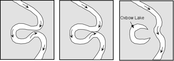
A floodplain is a flat, low area characterized by periodic inundation by overflow from a stream or river and has a meandering river, meander scars, oxbow lakes, and wetlands. The Red River is a meandering river that has smooth curves that bends and twists in a continuous pattern. A loop or bend of the river can be cut off from the main channel when deposition occurs on the inside of the bend and erosion occurs on the outside of the bend (literally pinching the river at the neck of the bend) and forms an ox bow lake.
Meandering Channels
From: Prof. Stephen A. Nelson, Tulane University,
Physical Geography web site:
http://www.tulane.edu/~sanelson/geol111/streams.htm
Because of the velocity structure of a stream, and especially in streams flowing over low gradients with easily eroded banks, straight channels will eventually erode into meandering channels. Erosion will take place on the outer parts of the meander bends where the velocity of the stream is highest. Sediment deposition will occur along the inner meander bends where the velocity is low. Such deposition of sediment results in exposed bars, called point bars. Because meandering streams are continually eroding on the outer meander bends and depositing sediment along the inner meander bends, meandering stream channels tend to migrate back and forth across their flood plain.
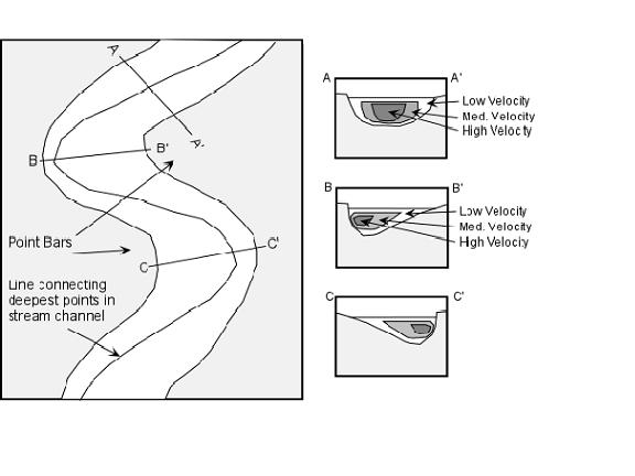
If erosion on the outside meander bends continues to take place, eventually a meander bend can become cut off from the rest of the stream. When this occurs, the cutoff meander bend, because it is still a depression, will collect water and form a type of lake called an oxbow lake
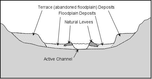
If water flow or stream discharge is suddenly increased, as it might be during a flood, the stream will overtop its banks and flow onto the floodplain where the velocity will then suddenly decrease. This results in deposition of such features as levees and floodplains.
As a stream overtops its banks during a flood, the velocity of the flood will first be high, but will suddenly decrease as the water flows out over the gentle gradient of the floodplain. Because of the sudden decrease in velocity, the coarser grained suspended sediment will be deposited along the riverbank, eventually building up a natural levee. Natural levees provide some protection from flooding because with each flood the levee is built higher and therefore discharge must be higher for the next flood to occur.
Terraces are exposed former floodplain deposits that result when the stream begins down cutting into its flood plain (this is usually caused by regional uplift or by lowering the regional base level, such as a drop in sea level).
Current Hydrology for Red River at Shreveport, Louisiana
Location of Gage Illinois Central Railroad Bridge at mile 228.2
| Stream Name: Red River | Longitude: -93/73971300 |
| Gage Zero: 131.48 Ft. NCVD 1929 | Latitude: 32.51578900 |
| Flood Stage: 30.0 Ft. | River Mile: 228.2 |
| Record High Stage: 45.9 Ft. | Record High Stage Date: 08/15/1849 |
| Record Stage Low: 0.20 Ft. | Record Low Stage Date: 11/08/1929 |
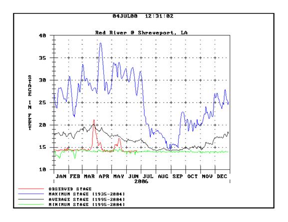
Source: US Army Corps of Engineers (http//www.mvk.usace.army.mil/offices/ed/edh/plots/shreve.gif)
Note: January 1 though July, 4, 2006 is unedited real time data.
August through December 2006 stages are estimates.
Composite Historic Hydrology for Red River at Shreveport
1955, 1985, 1995, 2005
Location of Gage Illinois Central Railroad Bridge at mile 228.2
| Stream Name: Red River | Longitude: -93/73971300 |
| Gage Zero: 131.48 Ft. NCVD 1929 | Latitude: 32.51578900 |
| Flood Stage: 30.0 Ft. | River Mile: 228.2 |
| Record High Stage: 45.9 Ft. | Record High Stage Date: 08/15/1849 08/15/1849 |
| Record Stage Low: 0.20 Ft. | Record Low Stage Date: 11/08/1929 |
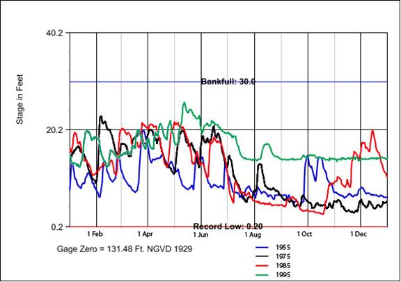
Source: US Army Corps of Engineers (http//www.mvk.usace.army.mil/offices/ed/edh/plots/shreve.gif)