The Lake Pontchartrain Basin Foundation
Geologic Formation of the Delta
Specific Environmental Concerns
Northshore: Covington/Mandeville Area
General Geography and Land Use of Mandeville
Urban Development of Covington/Mandeville Area
Background
Information
Northshore
Summary information on the Lake Pontchartrain Basin and its watershed area is a compilation of U.S. Army Corps of Engineer, Lake Pontchartrain Basin Foundation studies, reports, articles, website and CD-rom, Open File government documents, Internet accessible data, articles related to Lake Pontchartrain, and interviews with experts on wetland loss and change. Information on St. Tammany Parish and the Covington/ Mandeville area is a compilation of Internet sources, U.S. Census data, articles, and interviews with parish and city government officials. Only direct quotes or facts are cited. General information from multiple sources. References consulted are located at the end of this summary.
The Lake Pontchartrain Basin Foundation
The Lake Pontchartrain Basin Foundation (LPBF), a membership-based citizen’s organization, is the public’s independent voice dedicated to restoring and preserving the Lake Pontchartrain Basin. The Foundation was established in 1989 as a citizen's group to organize help with the restoration efforts in the basin, and works in partnership with all segments of the community to reclaim the waters and habitats for this and future generations.
The mission and goals of the LPBF are the same: to restore and preserve the Lake Pontchartrain Basin through coordination of restoration activities, education, advocacy, monitoring of the regulatory process, and citizen action. The Foundation promotes stewardship, protection of the estuary and its habitats, and restoration of the basin to a safe and clean environment.
The Foundation is making progress with many major accomplishments (Table 1.2). As a result of the Lake Pontchartrain Basin Foundation’s advocacy, shell dredging has been stopped, seagrasses are beginning to reestablish their colonies, local fishermen are seeing population increases in fisheries, and pollution levels in Lake Pontchartrain and basin rivers have decreased. The Foundation plans several future projects including assisting Orleans and Jefferson Parishes with programs to reduce sewage pollution along the southshore of Lake Pontchartrain, developing new educational resources and environmental programs, and initiating citizen involvement projects to restore habitats on both the north and south shores of Lake Pontchartrain. Saltwater intrusion and erosion from the Mississippi River Gulf Outlet (MRGO) remain a concern for the basin. Urban encroachment of fragile wetlands is an issue along the northshore of the basin. The Foundation is developing a long-term program to address the multiple issues within the Lake Pontchartrain Basin, and plans to develop a comprehensive wastewater management plan for Tangipahoa Parish, advanced treatment systems for individual home sewage systems, sewage disposal programs for camps in the Basin, and programs to eliminate pollution from boat repair yards.
Hosted 10 "Back-to-the-Beach" lake awareness festivals
Comprehensive management plan
Coordinated effort for cleanup of Pontchartrain Basin.
Environmental Education Programs
Classroom presentations; field programs; canal/river watch; summer camps; education guide; teacher workshops; "Pontchartrain Stories" video; grants to schools; educational materials; research; WETMAAP materials and workshops.
Cost-share program
Assist farmers with construction of animal waste retention lagoons.
Restoration of Lake Pontchartrain Basin
Initiated shell dredging ban
Challenged water quality permits
Established Big Branch Wildlife Refuge in St. Tammany Parish
Constructed a septic waste disposal facility for north shore parishes.
Prevented expansion of oil and gas operations with pollution records in the lake.
Sampling of more than 40 lake water quality sites monthly.
Replanting of seagrasses to replace losses due to past poor water quality, hurricanes, and shoreline erosion.
Provide Technical Advice, Help, Coordination, and Monitoring
Technical advice to over 100 northshore wastewater treatment plants.
Helped New Orleans develop long range plans to correct sewage infiltration into the lake.
Helped Jefferson Parish reroute storm water discharges away from the lake.
Coordinate efforts of thousands of volunteers that contribute tens of thousands of hours to help Save Our Lake.
Continuously watch over the Basin's waters and habitats 365 days a year.
Table 2.1: Selective list of Lake Pontchartrain Basin Foundation’s accomplishments.
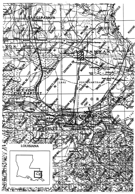
The Lake Pontchartrain Basin is in southeastern Louisiana and is just one part of a vast ecological system that includes three large lakes, Maurepas, Pontchartrain, and Borgne, which cover 55 percent of the basin (Figure 2.1). A land bridge of cypress swamp and fresh/intermediate marsh separates Lakes Maurepas and Pontchartrain. A peninsula of brackish marsh separates Lake Pontchartrain from Lake Borgne. The Lake Pontchartrain watershed is extensive and comprises many diverse habitats from upland evergreen forest to seagrass meadows. Water moves across fields and through forests as it finds its way to small streams in the forested hills north of the lake. This same water joins large rivers and bayous as it flows toward the lakes. One common factor uniting the entire watershed is that all of its water eventually arrives in a wetland for final filtering and purification before it empties into the Gulf of Mexico.
The basin comprises over 4,700 square miles of land in sixteen Louisiana parishes and four counties in Mississippi. All of these lands drain into surrounding rivers and bayous, which empty into Pontchartrain and its connecting sister lakes, Maurepas and Borgne. Lakes Pontchartrain and Borgne exchanges water with the Gulf of Mexico through a series of passes and outlets. This connection of the upper Basin’s fresh water with the salt water of the Gulf of Mexico makes Lakes Pontchartrain, Maurepas, Borgne one of the largest estuarine systems in the nation (Figure 2.2). The basin is known for its slow flowing rivers and bayous, tranquil swamps, and lush hardwood forests. It provides essential habitat for many species of fish, birds, mammals, reptiles, and plants. The wetlands and marshes surrounding the basin’s waters provide a beautiful setting and are the heart of the region’s commercial and recreational fisheries. The Lake Pontchartrain Basin is a unique ecosystem for the Gulf of Mexico Coast exhibiting great biodiversity and economic potential.
The basin area is home to 1.5 million people, more than one quarter of Louisiana’s population. Over the last 150 years the urban growth of New Orleans and the northshore communities and the exploitation of natural resources have severely altered the environmental quality of the Pontchartrain Basin.
Figure 2.1: Location of Northshore site and Lakes Pontchartrain and Maurepas.
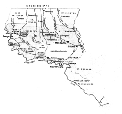
Figure 2.2: The Lake Pontchartrain Basin estuarine system.
Geologic Formation of the Delta
The Pontchartrain Basin is the largest marginal deltaic basin in North America measuring about 200 km along dip and 75 km along strike. The basin is bounded by incised Pleistocene terraces and small bayhead deltas to the north, the Mississippi River delta plain to the south/southwest, and relic Pine Island barrier shoreline to the south/southeast.
Radiocarbon dates for the Pontchartrain Basin show a complex history of sea- level withdrawal, rise, and stillstand followed by barrier shoreline development and deltaic enclosure. The Pontchartrain region was dissected by a series of entrenched river valleys during the Late Wisconsin low stand. Sea level rose during deglaciation, submerging this landscape and depositing a blanket of transgressive nearshore deposits. The Gulf of Mexico shoreline was eroding into the Pleistocene terraces and the formation of a barrier shoreline trend was initiated. The large recurved spit and island complex was built.
Lake Pontchartrain overlies a geologic region that is in a transitional position between two geologic provinces: the Lower Cretaceous margin and the Tertiary basin.
The Lake Pontchartrain Basin began forming about 5,000 years ago when the North American glacier melts caused the Mississippi River to swell and shift to the east. The river deposited sediments into the Gulf of Mexico creating a broad delta, which would later become Orleans, St. Bernard, and Plaquemines Parishes (Figure 2.3). The delta grew slowly eastward over 2,000 years and eventually separated a large body of water from the gulf.
Lake Pontchartrain was formed when the St. Bernard Delta of the Mississippi buried the Pine Island beach completely, covering most of the area and extending out to the Chandeleur Islands. A constricted opening was left about where The Rigolets now exists. Lake Borgne and the eastern part of Mississippi Sound were formed as the St. Bernard Delta was abandoned and began to deteriorate through subsidence and erosion, resulting in the cut through of a second opening, Chef Menteur Passes. Because of this cut, Lake Pontchartrain is a modified bar-built estuary and open water embayment with a surface area of 629 square miles.
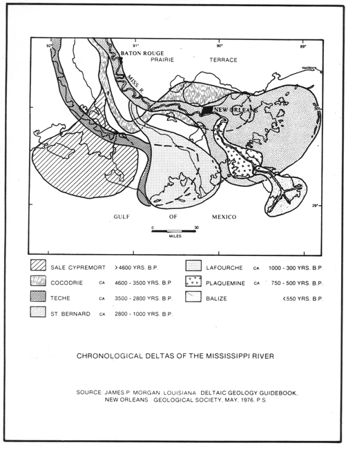
Figure 2.3: Chronological deltas of the Mississippi River.
About 2,000 to 3,000 years ago, the basin began to fill with prodelta, delta front, and crevasse deposits. Cypress swamps and fresh water marshes formed in the upper basin, and intermediate to saline marshes formed in the lower basin. The dominant trees in the forested wetlands are cypress, tupelo, willow, and water oak. Scrub-shrub wetlands are characterized by wax myrtle, cypress, iva, bacharries, sable palmetto, red maple, and willow. Salt marshes are dominated by oyster grass (Spartina alterniflora) and saltmeadows are dominated by wiregrass (Spartina patens).
Two dominant types of marsh are found in the basin: fresh marsh and brackish marsh. Fresh marsh has a one foot thick, dense, live root mat, while the brackish marsh occupies a complex transitional zone between fresh and saline areas with a thin layer of live roots and organic muck (up to 8 inches).
Specific Environmental Concerns in the Lake Pontchartrain Basin
Many environmental problems have arisen in the area because of human intervention. Human activities in the basin have resulted in loss or degradation of important essential habitats. Commercial and residential upland development and construction impact the water quality of the basin. Two damaging activities to wetland habitats are dredging and filling. Water quality problems escalate with increased development around the lake shore, which affects the basin’s diverse habitats. Loss of wetlands and other critical habitats are due to pollution, hydrological alterations, and development pressures. Non-point source pollution (NPS) is the major cause of water pollution in the Lake Pontchartrain Basin. Urban stormwater runoff, sewage outflow, and agricultural runoff carry various pollutants as they flow into lakes, streams, and rivers within the basin. NPS pollution is difficult to identify and prevent because everybody generates some form of NPS pollution. The lake's southern shore was once a popular place to swim, fish, and picnic, but due to the pollution problems the area has been closed since the 1960s; the northern shore was closed to the public because of farm and agricultural runoff.
Most of Louisiana’s coastal marshes are subsiding or sinking. Subsidence coupled with sea-level rise results in erosion and habitat change. Nearly all the shoreline of both Lakes Maurepas and Pontchartrain is eroding, typically at a rate of 5 to 10 feet per year, with variation in erosion rates due to shoreline configuration and sediment types. Storms are the principal force for this erosion. Saltwater intrusion, too, plays an important role in exacerbating problems within Lake Pontchartrain. Dramatic effects of salt water intrusion are noticeable in proximity to the MRGO navigational ship channel, oil and gas canals, levee extraction canals, and drainage ditches. The Northshore has more limited saltwater intrusion. The biggest factor in the loss of wetlands for the northshore, however, is urban sprawl into wetlands and into uplands adjacent to wetlands, resulting in loss or change in habitats and sewage and flooding problems. Example solutions for reducing erosion and salt water intrusion include filling of existing pipeline canals, building of rock dikes near Martello Castle in Lake Borgne and between Lakes Maurepas and Pontchartrain, planting vegetation along shorelines, and placing rock weirs at the ends of pipeline canals.
Covington/Mandeville Area
of
Lake Pontchartrain Basin
The Northshore site for Lake Pontchartrain Basin is located in St. Tammany Parish, a rural parish with three concentrated urban areas: Slidell to the east with a population of approximately 75,000, Covington to the north with a population of approximately 18,000, and Mandeville in the center with a population of approximately 10,000.
The location for the Northshore site is the Covington/Mandeville area with focal issues of sub-urbanization and urban sprawl affecting changes in wetland habitats and adding stress to the Northshore watershed area. Urban sprawl along the Northshore has resulted in increased marina development, apartment complexes, commercial development, and golf courses.
General Geography and Land Use of Mandeville
The following descriptive information about Mandeville is an exert from the Mandeville Comprehensive Land Use Plan of 1989. Although written in 1989, this is the current plan in use by the City of Mandeville. The information is still relevant, particularly the topography, drainage, sewage plans, and annexation needs, and forms the basis of current planning needs for the City of Mandeville.
It is important to provide a preliminary analysis of drainage basins in the study area because individual developments have a cumulative effect within this type of environmental unit. Evaluations of drainage patterns within basins and development of programs for water conservation will also assist the preservation of other environmental regimes. A cooperative effort between the City of Mandeville and St. Tammany Parish to quantify drainage basins and watersheds is in progress. The results of this study area of utmost importance in future planning and in determining development impacts.
The Prairie Terrace topography of the Greater Mandeville Study area (Figure 2.4) is subtle, with elevations ranging from twenty-five feet in the vicinity of Interstate 12 to zero feet in the marshlands west of Lewisburg. Within the present City Limits, elevations range from zero feet in the Mariner’s Village area and four feet on the shoreline of Lake Pontchartrain in areas adjacent to the floodwall, to sixteen feet along Highway 22. Except where elevations fall along the banks of creeks and bayous, there are no unbuildable slopes in the City or study area.
Drainage patterns in the Greater Mandeville Area are defined by Bayou Chinchuba and Bayou Castine, which flow into Lake Pontchartrain, and Bayou Tete L’Ours and Pontchitolawa Creek, which are tributaries of the Tchefuncta River. Figure 2.5 delineates the generalized drainage basins in the study area on the planning district base map.
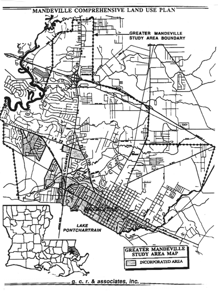
Figure 2.4 Greater Mandeville Area
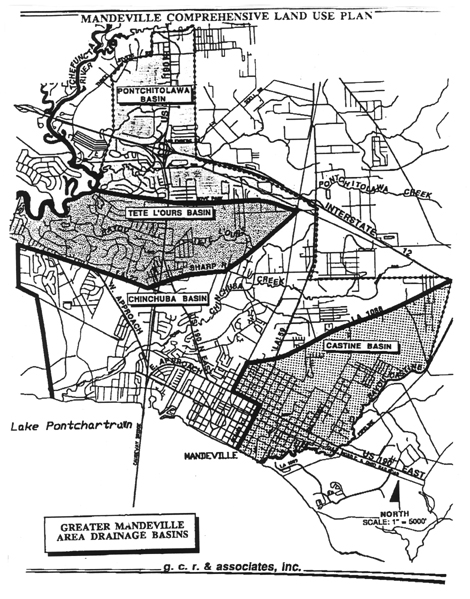
Figure 2.5 Generalized drainage basins
The boundaries of these basins are defined by ridges, upon which major roads are often constructed. These ridges divide the overland flow of water into adjacent rivers, bayous or creeks, which ultimately flow into Lake Pontchartrain.
The Castine and Chinchuba Basins drain the entire City of Mandeville and approximately half of the Greater Mandeville Area. These basins distribute water directly into Lake Pontchartrian, while the other two basins surround streams that are tributaries of the Tchefuncta River.
The soils of the Prairie Terrace geological formation are primarily of the Myatt-Stough Association. The soils of the Greater Mandeville Area are level, loamy soils, located outside of the floodplains of tributary bayous, which are stable and pose no restrictions to normal development. The top two soils horizons are comprised of topsoil and a "pan" or clay layer. This soil association is rated as only moderately suitable for septic systems because of slow permeability. However, it is suitable for road construction. There is no potential for subsidence in the Myatt-Stough soil association.
Sewerage and Sanitary Services
The sewerage improvement program that is now being implemented in Mandeville was designed for the projected year 2000 population of the Greater Mandeville Area with the expectation that the outlying areas, both developed and undeveloped, would eventually tie into Mandeville’s comprehensive sewerage treatment system. The Sewerage Improvement Program projected the year 2010 population for the Greater Mandeville Area at approximately 38,000 residents. This is about a four percent increase per year, which is consistent with the moderate rate projection for the City of Mandeville
The City of Mandeville contracts out solid waste collection services and uses the Parish landfill located in Big Branch. This facility is not adequate to meet the needs of the City and the Parish for the planning period. Recycling, incineration and other state of the art solid waste management programs have been recommended to the Parish.
Urban Development of the Covington/Mandeville area
Urban centers service multiple functions that a group of people believe are needed to support themselves. First, an urban area functions as a trade center at a local, regional, state, or national level. Second, as an urban area develops, its takes on the task of providing retail trade, support services, finance centers, education, and manufacturing. Economic and social stratifications exist in urban centers. The Covington/Mandeville region has developed from a summer home area to a thriving urban center.
One of the leading causes for erosion, wetland loss, and pollution of the Northshore of Lake Pontchartrain Basin is increased urbanization, especially extensive subdivision development to the north and west of the city of Mandeville during the past 10 years. According to Deborah Caraway Assistant Planner for Mandeville, "the impact of unincorporated areas [to the north and west of Mandeville] has a huge impact on the Lake’s wetland drainage." Photo Essay picture numbers 17 and 18 show the current vegetation filtering waste water system for the City of Mandeville -- a good method when built in the 1980's, but a system that is no longer adequate for the growing needs of the City. Unincorporated areas surrounding the city have private systems that drain into the watershed area adding to problems with wetlands. Summary findings of a wastewater management plan for St. Tammany Parish commissioned by LPBF in 1996, found that:
This growth and development has put a strain on the local environment, especially on surface water quality. One-fourth of the parish is surface water. The USGS (1996) reported sewage contamination in six bayous and parts of both river systems in STP [St. Tammany Parish]. Although other factors, such as agriculture and urban run-off, greatly affect surface water quality in STP, improperly treated sewage discharge has been identified as a critical source of pollution. Sewage pollution in STP has been found to be related to poorly maintained septic tanks, inadequate infiltration systems for septic tanks effluent, improperly operated and maintained mechanical treatment devices, and discharges from small wastewater treatment plants....In the three larger municipalities [Mandeville, Covington, Slidell, and Abita Springs] high infiltration and inflow into collection systems appear to be most pressing issues (Knecht 3-4, 1997).
The report continues with a qualification that "Wastewater management in STP, although more critical outside incorporated areas, should not be considered only a problem of the unincorporated portion [of the Parish]" (Knecht 4, 1997). Possible solutions suggested for improving the sanitation situation for St. Tammany Parish are limiting population growth, providing a Parish-wide system, and improving current systems.
Population Growth and Economic development
Statistical figures on income for the years 1970, 1980, and 1990 for Louisiana, New Orleans, and St. Tammany Parish suggest that increased population growth for the Northshore of Lake Pontchartrain Basin and St. Tammany Parish is a direct result of an urban exodus from New Orleans and its suburbs. The City of Mandeville decided to purchase land — a large percentage was wetlands — in the 1990's to offset some of the potential environmental problems. The last major annexation for the City was between 1995-96 (Caraway, 1999). In 1997, The City of Mandeville officially listed 33 subdivisions, with nine subdivisions developed since 1990. Currently, several subdivisions in unincorporated areas adjacent to the City are under review for annexation.
Several reasons explain the population shift for the rural parish of St. Tammany, especially the Covington/Mandeville area. First, the building and opening of the Causeway in the 1950's allowed direct access to the Northshore, an area that was considered in the early 1900's to be vacation and health resort region. Figure 2.6 is an example of growth between 1958 and 1967 for Mandeville. Second, improving the Causeway from a two to a four-lane highway in the late 1970's added to the population flight from the New Orleans area. At that time, the real estate market and building costs
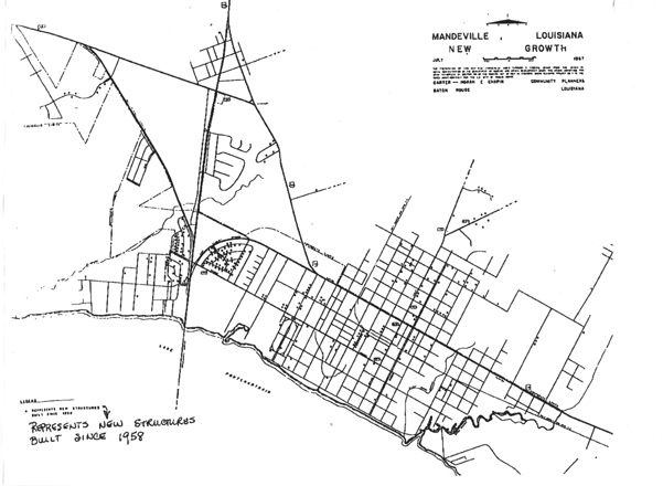
Figure 2.6 Example of suburban development
for the Mandeville area were low. New suburbs developed, offering affordable housing. The middle and upper-middle class labor force could afford to commute from the Mandeville area to New Orleans. Quality of life was an impetus for movement from other areas to the Northshore. St. Tammany-West Chamber of Commerce promotes a rural setting as offering all the amenities necessary for a good life including choice of subdivisions, historical residential areas, country estates, and quality medical facilities, retail services, and an award winning school system.
The City of Mandeville experienced an increase in population after 1950 and a rapid growth between 1970 and 1990. Mandeville has had a tremendous growth in both population and retail businesses from 1990 to current. The peak of this economic and population growth occurred between 1995-1998.
A comparison of housing prices for the Northshore area shows that prices escalated from an average of $60,000 in the mid-1980's to over $150,000 in the mid-1990's. Land values have doubled since 1990. For example, the average lakeshore home in 1991 sold for approximately $250,000 and above , while the average lakeshore property sold for over $500,000 in 1999. Some of the early Lewisburg and Mandeville housing were established as second homes, and now most have been converted to year-round residences. Such homes are now selling for high prices because the lakeshore property is very valuable.
Beginning in the late 1970's lower land and housing prices, a good school system, and "elbow room" encouraged population movement to the Northshore that began to reflect Mandeville as a bedroom community for New Orleans. Middle and upper class families employed in a booming oil and gas industry in the early 1980's, added to professionals within education and the medical field, were already moving to the Northshore. However, current growth and development is a direct response to retail and wholesale trade industries developing on the Northshore. Because of population and economic growth, the Northshore has experienced a multiplier effect within its
infrastructure. Support services such as retail needs and school demands have increased. People move to the area for jobs, better commuting time, and the schools. The Mandeville area school system is believed to be one of the better systems within Louisiana. The increasing population demands of the 1980's and early 1990's on the Mandeville school system resulted in the use of portable classrooms until new schools could be built. Several new school complexes have been constructed to relieve the pressure on the existing schools and to accommodate projected enrollment.
Retail trade has boomed within the last 10-12 years. Before 1990, the area did not have an economic base large enough to support excessive retail trade. Instead, residents depended upon regional trade centers such as Hammond, Slidell, and New Orleans. Since 1995, however, retail and wholesale trade has expanded on the Northshore. Anchor tenants such as Old Navy, K-Mart, Home Depot, and several supermarket chains anchor local intersection strip malls. The growing number of medical facilities, restaurants, and other support business’ suggests that Northshore residents no longer need to commute or travel to other regional areas because basic and amenity services are provided within the area.
Effects of Urbanization and Suburbs on Northshore Wetlands
The change in the Northshore urban structure has been a direct result of population growth. Increased urbanization and development has resulted in building and improving shopping centers, expanding and widening roads, new subdivisions, and new schools. The development of new homes and subdivisions has placed a strain on existing infrastructures especially the school system, medical facilities, and other public services such as police, fire, and wastewater treatment.
As a result of the rapid and expansive growth of the Northshore, concern exists about: 1) changes to the shoreline of Lake Pontchartrain, 2) direct alterations to wetlands, 3) increases in stormwater runoff, 4) overburdened wastewater treatment systems, 5) indirect impacts on wetlands cause by all of the above.
Total Population:
1980
Louisiana
St. Tammany Parish seat:
Covington
Three largest parish urban centers:
Slidell
Covington
Mandeville
Climate:
Annual average temperature:
69�
Monthly average temperature: January 55�
July 82�
Annual average rainfall:
55.8 inches
Average elevation:
9 feet
Taxes:
State:
4%
Parish:
4.25%
Municipal range:
4.25-4.75%
Parish mileage rate (1998)
167.3
Governments:
Slidell:
Mayor/Council
Covington:
Mayor/Council
Mandeville:
Mayor/Council
Major employers:
| Type | # of
employees |
|
| St. Tammany Parish School System | Education | 3,526 |
| Slidell memorial Hospital | Medical | 1,100 |
| Northshore Regional Medical Center | Medical | 682 |
| St. Tammany Parish Hospital | Medical | 680 |
| St. Tammany Parish Sheriff’s Office | Law Enforcement | 356 |
| City of Slidell | Government | 300 |
Source: http/leap.nlu.edu
Wholesale Trade: 1987 and 1992
Economic Census
POPULATION
TOTAL PERSONS 1910-1989
| 1940 |
1950 |
1960 |
1970 |
1980 |
1990 |
1998 |
|
| Louisiana (state) |
2,363,880 |
2,683,516 | 3,257,022 | 3,641,306 |
4,205,900 |
4,219,973 |
4,368,967 |
| St. Tammany Parish Total |
23,624 | 26,988 |
38,643 | 63,585 |
110,869 |
145,391 | 188,936 |
| Mandeville (city) |
1,326 | 1,368 |
1,740 |
2,282 | 6,076 |
7,083 | 9,006 |
| New Orleans (city) |
494,537 | 570,445 | 627,525 | 593,471 | 557,515 | 496,938 |
465,538 |
TOTAL PERSONS Percent Changes 1910-1989
| 1950 |
1960 |
1970 |
1980 |
1990 | 1997 |
|
| Louisiana (state) |
11.9 |
17.6 |
10.6 |
13.4 | .3 |
3.4 |
| St. Tammany Parish Total |
12.5 |
30.2 |
39.2 |
42.6 |
23.7 |
23 |
| Mandeville (city) |
3.1 |
21.4 |
23.8 |
62.4 | 14.2 | 21.4 |
| New Orleans (city) |
13.3 |
9.1 | -5.7 |
-6.4 |
-12.2 |
-6.7 |
St. Tammany Parish
Age Structure
1990
| Years of Age |
Louisiana |
St. Tammany Parish |
The City of |
| 0 - 4 |
334,650 | 11,583 | 575 |
| 5 - 9 |
358,365 | 13,215 | 688 |
| 10 - 14 |
342,455 |
12,391 | 600 |
| 15 - 19 |
332,140 |
10,640 |
440 |
| 20 - 24 |
324,170 |
7,254 | 377 |
| 25 - 29 |
345,375 |
10,704 |
615 |
| 30 - 34 |
358,547 |
13,316 |
627 |
| 35 - 39 |
326,787 | 13,744 |
750 |
| 40 - 44 |
279,149 |
11,633 |
619 |
| 45 - 49 | 221,362 | 9,117 |
427 |
| 50 - 54 | 185,078 | 6,998 | 259 |
| 55- 59 |
171,927 | 5,649 |
202 |
| 60 - 64 | 170,977 |
5,377 |
312 |
| 65 - 69 |
155,859 |
5,028 | 225 |
| 70 - 74 |
119,149 | 3,359 |
159 |
| 75 - 79 | 91,394 | 2,058 |
71 |
| 80 - 84 |
58,956 | 1,348 |
73 |
| 85 and Over | 43,633 |
1,094 | 64 |
Source: http://venus.census.gov
Selected Age Structure 1990-1997
Enumeration and Percent of Population
Age |
1990 |
1991 |
1992 |
1993 |
1994 | 1995 |
1996 |
1997 | ||||||||
| # |
% |
# |
% |
# |
% |
# |
% |
# |
% |
# |
% |
# |
% |
# |
% |
|
| under 20 years |
47,3298 |
32 |
48,841 | 32 | 50,203 | 32 |
51,737 |
32 |
53,577 |
32 |
55,336 |
32 | 56,228 |
31 |
57,161 |
30 |
| 65 years and over |
12,890 |
8 |
13,412 |
8 | 13,976 |
8 |
14,652 | 9 |
15,264 |
9 |
15,903 |
9 |
16,482 | 9 | 17,037 |
9 |
School Enrollment And Type of School
Persons 3 years and over
| Louisiana |
St. Tammany Parish |
The City of |
|
| Preprimary
School |
80,054 | 3,398 |
254 |
| Elementary/High School |
842,472 |
30,412 |
1,451 |
| College |
263,233 |
6,955 |
389 |
High School and College Graduates
1990
Persons 25 years and over
| Louisiana | St. Tammany Parish |
The City of |
|
| Number of persons 25 years and over |
2,536,994 |
89,425 |
4,403 |
| Percent high school graduates | 68.3 |
76.9 |
88.5 |
| Percent college graduates |
16.1 | 23.1 | 34.3 |
Number of Households 1990
| Louisiana |
St Tammany Parish |
The City of |
| 1,498,371 |
50,388 |
2,655 |
Annual Income 1969 - 1997
5 Year Intervals
in Dollars
| Louisiana | % Change |
New Orleans MSA | % Change |
St. Tammany Parish |
% Change |
|
| 1997 |
20,458 | 8.6 |
|
8.7 |
24,224 |
9.7 |
| 1995 | 18,826 |
27.4 |
21,293 |
24.9 |
22,078 |
23.6 |
| 1990 |
14,774 | 24.4 | 17,047 |
25.5 |
17,855 | 28.2 |
| 1985 |
11,876 |
35.2 |
13,578 |
37.2 |
13,918 |
39.0 |
| 1980 |
8,781 |
78.1 | 9,894 |
74.3 | 10,012 |
79.7 |
| 1975 |
4,930 |
59.4 |
5,676 | 54.4 |
5,571 |
67.1 |
| 1970 |
3,091 | 43.6 |
3,676 |
3,332 |
||
| 1997-1980 |
132.9 | 133.9 | 141.94 |
Source: http://venus.census.gov; http204.68.243.81/lois
Income and Poverty 1990
| Louisiana |
St. Tammany Parish |
The City of |
|
| Personal income per capita |
$15,919 | $13,605 |
$15,733 |
| Median household income |
$26,896 |
30,656 |
na |
| % of population below poverty level | 23.6% |
13.7% |
9.7% |
na: not available
Source: http://venus.census.gov
Place of Work and Travel Time
Employed persons 16 and over
1990
| Louisiana |
St. Tammany Parish |
The City of |
|
| Worked in county of residence |
1,217,736 |
35,112 |
1,923 |
| Worked outside county of residence |
395,728 |
23,867 |
1,388 |
| Worked outside of state residence | 32,226 |
2,573 |
97 |
| Mean travel time to work (minutes) |
30.1 |
28.3 |
Number of People in Industry
Employed persons 16 and over
1990
| Louisiana |
St. Tammany Parish |
The City of Mandeville |
|
| Employed persons 16 and over |
66,141 |
3,444 |
|
| Agriculture, forestry, and fisheries | 41,805 |
1,181 | 36 |
| Mining |
52,329 | 2,203 | 203 |
| Construction | 111,181 | 4,668 |
239 |
| Manufacturing, nondurable goods |
114,175 |
2,139 |
61 |
| Manufacturing, durable goods |
91,245 | 4,402 | 110 |
| Transportation, communications, and other
public utilities |
49,183 | 4,550 |
263 |
| Wholesale trade |
73,296 | 3,167 |
167 |
| Retail trade |
287,778 |
11,297 | 637 |
| Finance, insurance, and real estate |
94,423 | 4,484 | 358 |
| Business and repair services |
70,938 | 2,974 |
173 |
| Personal services |
58,160 | 1,833 | 133 |
| Entertainment and recreation services | 18,215 | 802 |
13 |
| Professional and related services |
|||
| Health services |
147,984 | 5,719 |
388 |
| Educational services |
168,257 | 4,677 | 295 |
| Other professional and
related services |
99,605 | 4,136 | 282 |
| Public Administration |
84,206 |
3,503 | 86 |
Number of People by Occupations
Employed persons 16 and over
1990
| Louisiana | St. Tammany Parish |
The City of |
|
| Employed persons 16 and over |
66,141 |
3,444 |
|
| Managerial and professional |
|||
| Executive, administration,
and managerial |
170,420 |
8,419 | 535 |
| Professional specialty
occupations |
230,644 |
10,532 |
749 |
| Technical, sales, and administrative
support |
|||
| Technicians and related
support |
59,903 | 2,526 |
146 |
| Sales occupations |
202,782 | 9,528 |
679 |
| Administrative support, plus clerical |
254,084 |
8,334 | 424 |
| Service occupations |
|||
| Private household occupations |
12,460 | 384 |
29 |
| Protective service
occupations |
34,175 | 1,277 |
38 |
| Service, except protective and household |
187,187 | 6,130 |
316 |
| Farming, forestry, and fishing |
40,295 |
1,086 |
28 |
| Precision production, craft, and repair |
205,909 | 7,177 | 262 |
| Operators, fabricators, and laborers |
|||
| Machine operators,
assemblers, and inspectors |
86,756 |
2,010 | 60 |
| Transportation and material
moving |
90,624 |
2,536 |
106 |
| Handlers, equipment cleaners,
helpers, laborers |
66,375 | 1,796 |
1967 and 1987
| LAND USE | 1967 |
1967
Actual % of Acres |
1967
(1987) Forecast Acres |
1967 (1987) |
1987 |
1987 |
1967 (1987) |
1967 (1987) |
| Single Family |
529.75 |
23.95% |
1,699 |
55.27% |
1,642.50 |
49.35% | -5.92% |
25.40% |
| Multi- Family | 4.63 | 0.21% | 168 |
5.47% |
94 |
2.83% |
-2.64% |
2.62% |
| Commercial |
36.85 |
1.67% |
163 | 5.3 % |
230 |
6.91% | 1.61% | 5.24% |
| Industrial &
Railroads |
85.36 |
3.8 % |
454 |
14.77% |
6 |
0.18% |
-14.59% | -3.68% |
| Institutional |
N/A | N/A | N/A | N/A |
98 |
2.94% |
2.94% |
2.94% |
| Public &
Semi-Public |
94.21 |
4.26% | 590 | 19.19% | N/A | N/A | -19.19% | -4.26% |
| Recreational | N/A | N/A |
N/A | N/A |
111.5 |
3.35% | 3.35% | 3.35% |
| Streets &
Services |
278.19 | 12.58% | --- |
--- | N/A |
N/A | N/A | -12.58% |
| Vacant |
1,182.17 |
53.47% |
--- |
--- |
1,146 | 34.44% | 34.44% |
-19.03% |
| TOTALS | 2,211.16 |
100.00% | 3,074 |
100.00% |
3,328 |
References Consulted for St. Tammany Parish and the City of Mandeville
The City of Mandeville and St. Tammany Parish post planning documents and statistics on their websites. Other information related to the Northshore site was collected from Louisiana State Census documents and experts within specific fields of study.
http://www..newsbanner.com/resource_dir/business
http://www.lapage.com/parishes/stamm.htm
http://www.thecauseway.com
http://infoplease.lycos.com/bus.html
http://stp.pa.st-tammany.la.us/stpback.html
/departments/development/complan/overview/overview.html
/departments/development/complan/vision/vision.html
/departments/development/complan/meetings/meetings.html
http:/www.tammanyschools.k12.la.us/ataglance.html
http:/www.state.la.us/state/census/census.htm
http://leap.nlu.edu/pprof98/sttamman.htm
/wholesal/mandevil.txt
/zipcode
/zipbusi/1995
/staab/chap06/tab0613.txt
/SOLC/STTAMMAN.txt
/SOLC/NEWORLEA.TXT
/SOLC/MANDEVIL.TXT
/POPHS/NEWORLEA.TXT
/POPHS/STTAMMAN.txt
/POPHS/MANDEVIL.TXT
/LABOR/NEWORLEA.TXT
/LABOR/STTAMMAN.txt
/LABOR/MANDEVIL.TXT
/INCPV/NEWORLEA.TXT
/INCPV/NEWORLEA.txt
/INCPV/MANDEVIL.TXT
http://www.riversentinl.net/issuews/water.html
/develope/sustain3.html
/develope/sustain4.html
/develope/sustain5.html
http://fema.gov/impact/cities
Knecht, A., J.C. Josse, and J.W. Sutherlin. 1997. Wastewater Management Plan for St. Tammany Parish: Technical, Financial, and Insitutional Considerations:
Project Summary. University of New Orleans’ Urban Waste Management and Research Foundation.
Mandeville Comprehensive Land Use Plan. 1989. The City of Mandeville, Planning Department.
Other References Consulted
Anderson, Bob. 1997. Shipping channel blamed for coastal erosion problems. Big Advocate. May 18, 1997.
Banbury, M.M., Rheams, A.B., Lyons, S.E., Flanagan, S., Greene, M. C. 1997. Lessons on the Lake: An Educator’s Guide to the Pontchartrain Basin. Metairie,
LA: The Lake Pontchartrain Basin Foundation.
Caraway, Debbi. 1999. Planner, City of Mandeville. Telephone Converstaion.
CDROM An Environmental and Geological Bibliography for Lake Pontchartrain, Louisiana. U.S. Geological Survey Open File Report #96-527.
Cirillo, Stephanie. Save Our Lake. Lake Pontchartrain Basin Foundation.
Louisiana.
Coastal Management Division, Louisiana DNR. 1984. Geology in the proposed Pontchartrain-Maurepas Special Area in Environmental Characteristics of the
Pontchartrain-Maurepas Basin and Identification of Management Issues.
Costly Corps: How the U.S. Army Corps of Engineers Spends Your Tax Dollar to Destroy America’s natural Resources. 1996. Prepared by the Gulf
Restoration Network and the Sierra Club Legal Defense Fund, April 15, 1996.
Dufrechou, Carlton. 1996. Restoration of the Lake Pontchartrain Basin
[http://woodshole.er.usgs.gov/CDROMS/Pontch96-527/datbase/abs3.txt]
Gammill, S.P. 1996. Overview of Coastal Restoration Projects in the Pontchartrain Basin Authorized Under the Coastal Wetlands Planning, Protection,
and Restoration Act of 1990.
[http://woodshole.er.usgs.gov/CDROMS/Pontch96-527/datbase/abs3.txt]
Gulf Restoration Network and Sierra Club Defense. 1996. Costly Corps: How the U.S. Army Corps of Engineers spends your tax dollars to destroy
America’s natural resources. April 15.
Guntenspergen, G.R., Vairin, B.A. (1996). Coastal Wetlands. Willful Winds; Hurricane Andrew and Louisiana’s Coast. Louisiana.
Handley, Lawrence. 1982. Environmental Information on Hurricanes, Deep Water Technology, and Mississippi Delta Mudslides in the Gulf of Mexico. BLM Open
File Report 80-02.
Kendrick, D, Briand , et al. 1996. Construction of a 7100' Long Segmented Geotextile Tube Breakwater Along the North Shore of lake Pontchartrain.
[http://woodshole.er.usgs.gov/CDROMS/Pontch96-527/datbase/abs3.txt]
Lopez, John A. 1996. Historic Oil and Gas Production in Lake Pontchartrain.
[http://woodshole.er.usgs.gov/CDROMS/Pontch96-527/datbase/abs3.txt]
Louisiana Coastal Wetlands Conservation and Restoration Task Force. 1993. Louisiana Coastal Wetlands Restoration Plan: main Report and Environmental
Impact Statement. November 1993.
Louisiana Land Use/Land Cover Poster Map. 1998
Pontchartrain Basin Comprehensive Management Plan, Phase II (Draft). 1992. Prepared by College of Urban and Public Affairs, University of New Orleans, Louisiana, Nov. 1992.
"Pontchartrain Stories" Video. 1997. Lake Pontchartrain Basin Foundation
Save Our Lake. 1998. Lake Pontchartrain Basin Foundation.
Schleifstein, Mark. 1990. Human intervention breaks ancient rhythm. The Times-Picayune. March 26, 1990, p.22.
Schurtz, Michael, H. 1984. Report on Interim Findings: Water Quality Investigations in the Lake Pontchartrain prepared for the Louisiana Department of
Environmental Qaulity Water Pollution Control Division.
SEMaps. 1998. Mississippi River Delta Plain: Description of Landforms and Geologic Development.
Williams, S.J, et all. 1996. Holocene Geologic Framework and Development of the Pontchartrain Basin
[http://woodshole.er.usgs.gov/CDROMS/Pontch96-527/datbase/abs3.txt]