WETMAAP Skill 1
Mono Lake - Element 18
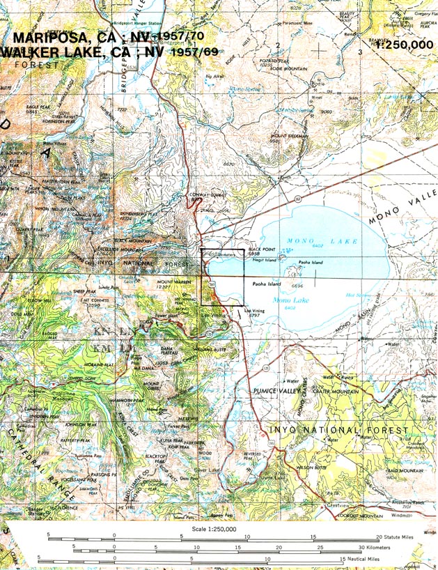
Skill 1: Map Use
Element 18: Use of Space Shuttle Image
Materials:
Mono Lake 1994 Space Shuttle Image
1:250,000
scale Mariposa/Walker Lake CA-NV Topographic Map
9”x 9 “ Clear Film Overlay
Green, Orange, Yellow, Blue, and
Black Marker Pens
Drafting Tape
Exercises:
1.
Use the Mono Lake
1994 Space Shuttle Image.
2.
Use the 1:250,000
scale Mariposa/Walker Lake CA-NV Topographic Map.
3.
Tape the Clear Film
Overlay over the Mono Lake 1994 Space Shuttle Image.
4.
Use the Black colored marker pen and trace the 1994
shoreline of Mono Lake, including the shoreline around the island in the lake.
5.
Is the Space Shuttle Image a larger or smaller scale than the
1:250,000 scale topographic map? _____________________________________________
6.
How did you
determine the answer to Question 5? ___________________
7.
What is the White colored area on the left side of the Space
Shuttle Image?
____________________________________________________________
8.
What are the White colored areas around the shore of Mono Lake?
____________________________________________________________
Hint: Look at Plates 3 and 4 in the
Photo Essay.
9.
Locate the White colored areas seen in Plates 3 and 4 in the
Photo Essay on the Space Shuttle Image.
10.
Tape the 9”x 9” overlay
onto the Space Shuttle Image.
11.
On the Space Shuttle Image we can
see four major glacial valleys emerging from the Sierra Nevada mountain front into the
Mono Basin.
a. Use the Blue colored marker pen and draw (with a single line) the glacial valleys’ streams within the valleys and emerging from the mountain front.
12.On the Space Shuttle Image we can see at least three older shorelines of Mono Lake.
a. One shoreline that is well defined (probably from Recent times, but not in the historical record) is just above the present shoreline. Use the Orange colored marker pen to draw this shoreline.
b. The oldest shoreline can be seen best in the northeast section of the Basin. Use the Green colored marker to draw this shoreline where it can be seen on the image.
c. Between the Orange and Green shorelines you have drawn, there are about 15 other shorelines, each one denoting a point at which the receding lake level remained for an extended period of time. There is one shoreline about halfway between the Red and Orange shorelines that stands out better than the others. Can you find it? If you think you can follow it around the lake, all the way or in part, use the Yellow colored marker pen and trace it on the overlay.
d. Label the four shorelines you have drawn on the overlay as
Present Day
Recent
Post-Pleistocene
Pleistocene