Golden Meadow Background
Information
Barataria- Terrebonne Estuary Louisiana
The Mississippi River and its importance to the Barataria-Terrebonne Estuary
Specific Environmental Concerns
Background Information
Barataria-Terrebonne Estuary
Louisiana
General statements and explanation of the Geographic Summary are a result of field observations by the WETMAAP Team and a composite of information from multiple sources.Sections describing the culture are from interviews, field observation, The Longest Street: A Story of Lafourche Parish and Grand Isle, and Avery and Weeks Island Geographic Summary, a compilation of information from Southeast Maps, which was funded by the National Science Foundation through Clemson University, Clemson, South Carolina and WETMAAP (Wetlands Education Through Maps and Aerial Photography).Sections explaining the location, general description, physical setting, and vegetative pattern of the Barataria-Terrebonne estuary, and the Mississippi River, water modification and water salinity, and causes of wetland loss are from the Executive Summary and the general text of the Barataria- Terrebonne National Estuary Program BTNEP Publ. No. 20, Status and Trends of Hydrologic Modification, Reduction in Sediment Availability, and Habitat Loss/Modification in the Barataria and Terrebonne Estuaries Systems Denise J. Reed, editor. Some sections are combined or modified to reflect the focus on the Golden Meadow site.Direct passages from the BTNEP Publ. No. 20 are not cited; additional statements that further clarify issues are from multiple sources, which are listed under Resources Consulted found at the end of the geographic summary. Note: The Geographic Summary is a compilation of information from existing sources and is intended to provide a brief synopsis of the Barataria-Terrebonne program, the estuary, and the Golden Meadow site.It is not meant to be an in-depth treatise on the geography and background of the area.
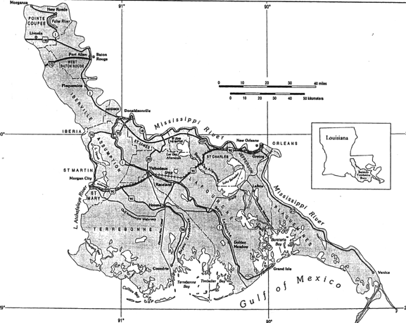
The Barataria-Terrebonne estuary is located in southern Louisiana (Figure 2.1).
style="mso-spacerun: yes"> The estuary is flanked by two of the largest
rivers in the United States, the Mississippi on the east edge and the Atchafalaya on the
west edge. These rivers carry a combined
average of 15,360 cubic meters per second of water (maximum flood flow of 57, 900 cubic
meters per second), a daily sediment flow of 1 to 1.5 million metric tons. The Mississippi River is leveed, and the levees on its west bank prevent the historical spring
overbank flooding into the estuary. Most of the water and sediments are now carried beyond
the mouth of the river into the deep water at the edge of the continental shelf where most
of the sediment is deposited. This sediment
is lost from the coastal system. The
river’s freshwater and the finest sediments, however, are usually carried by
prevailing currents in a large gyre westward, curving back eastward along the shore of the
Barataria Basin. Because the Atchafalaya
River is not leveed below the Avoca Island Cutoff (less than 10 miles below Morgan City),
some of its water flows out through flanking marshes and enriches them with nutrients and
sediments, building an active delta.
The
Mississippi River and its importance to the Barataria-Terrebonne Estuary
The Mississippi River had a strategic role in and
continues to be important in the development of the Barataria-Terrebonne estuary. Over the past 10,000 years the Mississippi River
has built the present southeastern coast of Louisiana as a series of overlapping delta
lobes (Figure 2.2). As the flow of the river
changed course, sediment was deposited to form successively more recent delta lobes. Marsh develops as plants invade the exposed
sediments of each delta lobe. This marsh
becomes a valuable wildlife habitat and serves as nursery grounds, shelter, and nutrient
source for the development of abundant populations of fish and shellfish. As the transition from one delta lobe to another
occurs, the older delta lobe is left without frequent deposition of sediments allowing the
older deltaic sediments to compact. This
results in subsidence of the marsh surface.
With the development of man-made levees along the rivers and bayous, fresh water and sediment is not available to counter the force of subsidence, and the resultant intrusion of saltwater from the gulf.
Figure 2.1: Location and
Boundaries of the Barataria-Terrebonne Estuary
(Source: BTNEP Publ. No. 20, Status and Trends of Hydrologic Modification, Reduction in Sediment Availability,
and Habitat Loss/Modification in the Barataria and Terrebonne Estuaries Systems, Denise J. Reed, editor.)
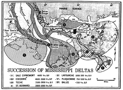
Figure 2.2: Succession of
Mississippi Deltas
Source: Avery and Weeks Island Geographic Summary,
Southeast Maps, funded by the National Science Program through Clemson University,
Clemson, South Carolina and WETMAAP (Wetlands Education Through Maps and Aerial
Photography).
Saltwater intrusion occurs as the marsh surface continues to subside and freshwater is not available to push back the gulf. The wetlands, barrier islands, and freshwater from rivers and streams keep the gulf from intruding into the upper part of the ecosystem, including fresh marshes, swamps, and freshwater bayous. As the wetlands degrade, and hydrologic modification reduces freshwater inflow, bayous, such as Lafourche become more vulnerable to invasion from the gulf. Bayou Lafourche supplies drinking water to 300,000 people, and freshwater for industrial operations. As saltwater increasingly intrudes, water intakes frequently must be shut down. Hence, the continued degradation of coastal wetlands is a critical problem in protecting the mainland, and inland water sources.
Marsh Development and Marsh Break-Up
Marshes develop on the delta lobes as plants invade the exposed mud flats. The plants that colonize specific areas are suited for that particular salinity regime. If flooding occurs from a sediment rich source such as the Mississippi River, the marsh plants can trap additional sediment, or slow water movement enough to allow sediments to settle. These processes can result in elevation of the marsh surface through deposition. Extended periods of inundation however may result in accumulation of toxic sulfides from anaerobic decomposition, killing plants, and making sediment more vulnerable to erosion. If saltwater intrudes into a fresh marsh, the habitat will be altered, as the plants and organisms that once thrived in the freshwater marsh cannot survive in saltwater. If the invasion of saltwater is gradual enough, plants and organisms that can thrive in a saltwater habitat begin to invade and succeed, eventually establishing a brackish marsh. As saltwater intrudes, the marshes may subside due to the increased weight of the saltwater, sediment sources being cut off, and high rates of sediment compaction in these geologically young sediments. The loss of marsh reduces the amount of storm surge buffer protection for the mainland against destructive weather patterns. The saltwater is able to intrude into less saline regimes, which stresses freshwater, intermediate, and brackish plants causing them to die; if this happens too quickly for more saline tolerant plants to become established, the marsh surface is eroded without vegetation protection, making more open water. More open water means more erosion, saltwater intrusion, loss of plants, more bare flats to be eroded, creating a cycle of marsh break-up and invariably marsh loss. A major problem within the Barataria-Terrebonne estuary is the disappearance of freshwater and saltwater marshes, which are an important economic resource and protective buffer for the region and the resulting increase in shallow open water areas.
Approximately 70% of the freshwater marshes in the Barataria-Terrebonne estuary are floating marshes, called flotant. These marshes develop in quiet, freshwater zones where organic matter builds up and forms a thick peat mat above the clay mineral layer. As the land subsides, there is a tug-of-war between the pull from below, and the natural buoyancy of the peat and the plants that colonize it. Often, the thick mat will eventually break free and float to the surface. When saltwater, or other stressful conditions invade these marshes and kill the vegetation, the floating mat loses some of its buoyancy, as gas-producing metabolic processes in the soil abate, and decomposing plants lose trapped air spaces. The marsh then breaks up and sinks. The loss of this freshwater flotant is another source of marsh break-up and marsh loss in the Barataria-Terrebonne estuarine system.
Much of the conversion of wetlands to open water in the estuary is attributed to a process called subsidence, which is the compaction of sediments beneath the marsh, causing it to sink. The erosional forces associated with hurricanes and flooding exacerbate this process. Prior to World War II, the natural process of subsidence was equalized by the sediments deposited from Mississippi River flooding. However, with the completion of the levee system along the Mississippi and Atchafalaya rivers, overbank flooding has been prevented. While World War II may be used as a defining moment in history for depositional changes in river sediments, the actual decline in sediments began much earlier. Other sediment milestones include levees built to their present height after the flood of 1927, and the arrival of floating oil rig in the late 1930’s and 1940’s, which restricted flow of sediments to the river (Curole, personal communication). Canals and navigation channels that cut through the marshes for cargo transport and oil exploration and production also are responsible for increasing marsh break-up. Such channels and canals provide an unrestricted access for saltwater to flow further inland, especially during drought conditions.
Barrier islands form when flanking barriers separate from the mainland through erosion caused by hurricanes, floods, and other weather patterns. As storms develop along or move toward the shoreline of Louisiana, barrier islands receive the brunt of the storm fury. Barrier
islands reduce the impact of the storm surge by reducing the energy, thus reducing the height storm surge heading towards shore.The sediments of the barrier islands
are removed during storms, reducing the linear extent and height of the island. The sandy sediments
from the barrier islands may become part of the inner shelf shoal (a collection of
sediment redeposited by over-active currents) or it may be carried by longshore drift
further along the coastline. Without sediment
input from the river, as was the case in the natural system, there is no longer a
continuous new supply of sediments to feed the barrier island formation. Over time, the barrier island becomes a part of
the underwater inner shelf shoal, no longer enabling it to protect the shoreline and
marshes. After the barrier island has
disintegrated, the shoreline becomes subject to erosion, which explains, in part, the
dissipating shoreline of Louisiana.
As the barrier islands diminish in size over time, and
the protection provided by these barrier islands no longer exists, the marsh which had
been protected from wave action will become more susceptible to erosion, possibly breaking
up and becoming lost.
The Barataria-Terrebonne estuary is composed of a number of different vegetative communities that reflect gradients in salinity (the relative supply of freshwater vs. marine water) and land elevation. The coastal marshes occur as adjacent bands of salt, brackish, intermediate, and freshwater vegetation lying parallel to the Gulf coast in a landward direction. These communities can be characterized by the following species associations: salt (Spartina alterniflora/Distichlis spicata), brackish (Spartina patens/Spartina alterniflora), intermediate (Spartina patens/Vigna spp./Sagittaria lancifolia/other spp.), and fresh (Panicum hemitomon/Sagittaria spp/Eleocharis spp./other species). Floating marshes are found in primarily freshwater areas, but also occur in intermediate and a few brackish areas. The dominant plant species in floating marshes are Panicum hemitomon and Eleocharis spp.
A change in vegetation indicates a change in other environmental parameters. Most likely, the change can be attributed to the intrusion of saltwater from the Gulf of Mexico to the freshwater marshes further inland. This intrusion may indicate increased erosion of barrier islands and marsh buffers, high rates of subsidence, and/or the lack of freshwater inflow. As the habitat changes, organisms’ dependant on the ecosystem must either adapt or move.
The most recent broad scale habitat
data available (1988) covers approximately 3.5 million acres of the 4.1 million acres
within the Barataria-Terrebonne Estuary System area.
Based on these data, and additional sources, there are approximately 909,000
acres of marsh (380,000 acres of fresh marsh and 531,000 acres of non-fresh marsh),
790,000 acres of forested wetland, and 1,500,000 acres of open water.
Most of the Barataria-Terrebonne
estuary is covered with marsh, however, large areas of forested wetland exist landward of
the freshwater marshes in the two sub-basins of the estuary. Forests are found in the upper reaches of the
estuary and can be divided into freshwater swamps dominated by bald cypress (Taxodium distichum) and water tupelo gum (Nyssa aquatic), with a red maple (Acer rubrum) and buttonbush (Cephalanthus occidentalis) understory; and
seasonally flooded bottomland hardwood forests dominated by several oak species (Quercus spp.), green ash (Fraxinus pennsylvanica var. lanceolata), and other hardwood species. These two types of forests occur about equally in
the Barataria-Terrebonne basin. In addition,
there is considerable area characterized as scrub/shrub, which increasingly refers to the
plant associations developing on elevated dredge deposits.
A unique plant association on the Caminada cheniere headland is all that remains of the coastal forests that used to fringe much of the coast, on the barrier islands and along the larger natural levees, such as along Bayou Lafourche. Nearly all this association has been cleared for habitation, or as in the case of Chenier Caminada, has subsided below an elevation that will support an upland forest. The remaining fragment is dominated by live oak (Quercus virginiana) and water oak (Quercus nigra), with hackberry (Celtis spp.) and other species. Buckbush (Baccharis halmifolia) and marsh elder (Iva frutescens) are the dominant shrubs, with considerable dwarf palmetto (Sabal minor) present. As the break-up
of the freshwater marshes continues, and the land continues to subside, increasingly the forested wetlands will be subjected to saltwater intrusion.Barrier island vegetation is
characterized by a number of species including Sesuvium
portulacastrum, Ipomoea stolonifera, Cakile geniculata, and Spartina patens.
The marshes on the landward edge of the islands are comprised of typical
salt and brackish vegetation, predominantly oyster grass (Spartina alterniflora) and the salt tolerant
scrub-shrub black mangrove (Avicennia germinans).
Tropical storms and hurricanes are
considered to be the most catastrophic storm events along the Gulf Coast. Hurricanes generally occur between May and
November with peak frequencies in September. Hurricanes
have major impacts on the water exchange, and hence the salinity distribution of Gulf
Coast estuaries. A hurricane affects these
systems by the addition of salt water through storm surges and fresh water through
exceptionally heavy rainfall. These hurricane
storm surges can cause massive flooding of coastal wetlands.
Hurricanes contribute to the erosion of the Louisiana coastline as well as the shoreline of the barrier islands and coastal marshes. As erosion in these areas continues, the land mass decreases, as does the amount of protection provided by the barrier islands and marshes. Because marshes buffer the developed areas from considerable storm surge impacts, the loss of the marshes along the coast reduces their storm protection capability.
For the residents of southern Louisiana, hurricanes have personal and economic implications. Area residents know that these intense tropical storms are large masses of energy that destroy property, changes landscapes, influence culture, and, in the worst cases, take human lives.
Hurricanes and their impacts on land can cause much destruction. Storm surge, high winds, torrential rains, and tornadoes are the main hazards associated with a hurricane. Of these hazards, the most deadly is the storm surge and the inland flooding that a surge creates which claim nine of ten victims. According to the Discovery Channel, 90% of injuries and deaths occur as a result of storm surges. The storm surge is created by the enormous force of high winds pushing masses of seawater inland. In large Category 5 hurricanes, the storm surge can be over 19 feet high (Table 2.1), and 100 miles wide. This wall of water can be devastating to anything in its path. These enormous storm surges and intense rainfall combine to flood low-lying areas many miles inland, often destroying property. As the marsh recedes, through subsidence and other forces, it provides less of a buffer. The salt present in the seawater also becomes a destructive force because fresh marsh plants are unable to survive long-term saturation in salt water.
Heavy rainfall from hurricanes and tropical storms can produce flooding; as well, associated high winds and tornados can also be catastrophic. Though hurricane winds tend to weaken the farther inland a hurricane moves, if accompanied by heavy rainfall, these winds an still be quite devastating through inland flooding. Golden Meadow was settled by the survivors of the great Hurricane of 1893, which took the lives of several thousand persons in the gulf coast. Ironically, the descendants of those survivors in Golden Meadow are now very vulnerable to devastation by hurricanes because of the tremendous loss of the wetland buffer. A storm surge from a category 4 or 5 hurricane could breach the 12-15 foot hurricane protection levee to the south of Golden Meadow. The degree of potential devastation would depend on the strength of the storm and the length of time it could pour water into Golden Meadow over the levees from the gulf, and from the skies through rainfall. Heavy rainfall can be controlled through pumping the water out, but only to a degree.
The threat of hurricanes has been present since the settlement of this area thousands of years ago. Examination of NOAA weather records show that a hurricane has made landfall in Louisiana approximately every three years since 1871. Figure 2.3 shows the storms of the north gulf coast. These storms have varied in intensity from small Category 1 hurricanes that
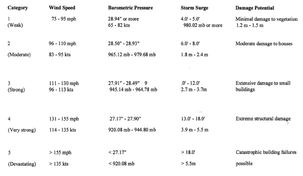
Hurricanes are rated in intensity on the Saffir-Simpson Hurricane Scale. This scale rates hurricanes by their wind speed, barometric pressure, storm surge height, and damage potential. (This information provided by the Federal Emergency Management Agency.)
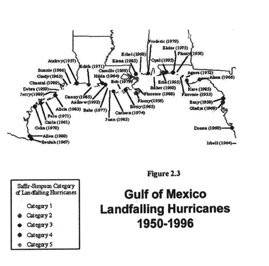
(Source: U.S. Geological Survey, National Wetlands Research Center, Lafayette, Louisiana)
cause little physical damage to large destructive Category 5 hurricanes that result in major damage. Hurricane Andrew in 1992 is the most recent hurricane to strike the coastline of the Barataria-Terrebonne estuary. Hurricane Audrey, coming ashore to the west of the Barataria-Terrebonne estuary, in 1957 claimed the lives of 526 people in the coastal area of Cameron. Hurricane Juan in 1985, spinning offshore of the Barataria-Terrebonne coast for five days, could probably be considered one of the most devastating of hurricanes because it piled up water in the estuary to a depth of nearly 10 feet for the five days it remained offshore.
The “Take Home Message” is that the estuaries, barrier islands, and marshes along Louisiana’s coast provide a buffer zone that drains a hurricane’s strength, but as this buffer zone decreases the potential for greater destruction from future hurricanes increases.
Southern
Louisiana is also the endpoint of the world�s third longest river system, the
Mississippi River. The Mississippi River drainage system drains and transports
sediment from over thirty states and parts of Canada to the Gulf of Mexico. The
flooding of the Mississippi has been and continues to be vital to the creation
of the wetlands of southern Louisiana through the sediments it carries. In
the past, these sediments were deposited in the estuaries and marshes of
southern Louisiana as the river flooded these areas. Alluvial
rich soil revitalized the marshes by supplying nutrients for growth and soil for
the natural development of new marsh. Presently,
this type of beneficial flooding occurs far less frequently because of current
flood control measures and the levee systems developed along the rivers,
primarily the Mississippi.
Levees are
necessary structures for flood protection within the Barataria-Terrebonne estuary. The levees provide protection for inhabited areas
in two respects: 1) levees along the Mississippi River prevent Mississippi River flood
waters from escaping the channel; and 2) hurricane protection levees which surround
communities such as Golden Meadow prevent hurricane storm surges from inundating an area,
and allow water to be effectively pumped out of the area.
Early settlements of the region were located on natural
levees adjacent to the Mississippi River that were less likely to flood. As settlement continued, the limited amount of
high ground that was available for settlement or agriculture production was depleted
forcing later inhabitants to settle further back from the natural levees in the lower
lying areas more susceptible to flooding. Settlers
built levees along the Mississippi River to protect their homes and crops from flood
danger because they recognized that flooding from the Mississippi would always be a
problem. Parts of this original levee system,
although modified, are still in use today (Curole, personal communication).
The periodic input of sediment and water that is critical in the formation and maintenance of Louisiana�s estuaries was lost when the channel of the Mississippi River was confined in place by massive levees. The millions of tons of topsoil and nutrients that were historically deposited on these marshes during the annual spring floods of the Mississippi no longer are deposited due to the levee system. Instead, the channel of the Mississippi extends to the edge of the continental shelf and the sediments that once built the marshes are now deposited into deep water that precludes the formation of new marsh, or maintenance of existing marsh along the coast. The loss of these resources through levee construction is believed to be the single biggest cause of wetland loss in southern Louisiana.
Levees have been created inadvertently within the marsh, from the dredge
material excavated when canals were dug for navigation or oil exploration
channels. These �spoil banks�
alter the normal sheet flow of water through the marsh or swamp, effectively
impounding the affected area so that water does not flow in or out. This
can result in the build-up of toxic chemicals such an hydrogen sulfide from
plant matter decomposition in the absence of oxygen, with potentially lethal
effects on a marsh or swamp.
Levees
are important to Lafourche Parish and residents of Golden Meadows because the
land area is only a few feet above sea level. The
heights of the levees containing the Mississippi River have gradually increased
from 3 feet in the early 1700�s to about 17 feet today. Storm
surge from the gulf and potential flooding from rainfall and the gulf are
constant dangers facing residents living along the Bayou Lafourche natural levee
and in adjacent low-lying areas.
The
levee system, while doing a good job of keeping water out, also does a good job
of keeping water in, which is a problem because there is insufficient drainage
for a heavy rainfall. Facilitation
of drainage through pumping is an important aspect of the levee system
especially during hurricane season since large storms bring large amounts of
rain to the area. The development
of the hurricane protection levees in South Lafourche has altered the natural
overland flow of heavy rain inside the leveed area. Normally,
the water would flow overland into the low lying marsh and swamp areas, away
from the inhabited areas, however, that runoff is now trapped inside the levees
and has to be channeled into drainage canals and pumped out of the leveed areas. Pumps
and pumping stations in low-lying areas control much of the excess rainwater (Curole,
personal communication). However,
at times, the pumps fail, or cannot keep up with the amount of water coming in,
so the threat of flooding is always present.
The past and current residents Golden Meadow and those residents living along Bayou Lafourche settled in the area because of the abundant natural resources including fish and shellfish, ducks and geese, furbearers for trapping and eating, and oil and natural gas.
The first inhabitants of the area were the Native Americans who utilized the plentiful resources available in Barataria-Terrebonne estuary. waterways provided easily accessible transportation routes, as well as high ground on the natural levees, and early inhabitants settled along bayous, rivers, and streams.These early settlers recognized the quality of the soil and planted crops to supplement the wild food sources.By the time the first Europeans settled in the estuary, a Native American culture consisting of well over 10,000 people was already living there.
The French settled in this region in the early 1700�s,
closely followed by a group of German immigrants, who were recruited by a French
company. These early settlers
gained valuable knowledge about the environment and the skills and techniques
crucial for survival from the Native American residents.
Throughout its history of settlement, ownership of
Louisiana transferred from the French to the Spanish, back to the French, and finally to
the United States through the Louisiana Purchase. During
this time, the population in Barataria-Terrebonne grew as more settlers moved to the
region to take advantage of the fertile soils and abundant resources available in the
estuary and to escape religious and political persecution.
The people who settled in this area over the years have literally come from
every part of the world. This blending of
beliefs and ideals has created a very diverse culture with worldwide influences.
The
melding of cultures within the estuary has been further modified by nature. Weather
affects everyone living within the estuary, and most livelihoods are dependent
upon the weather and the wetlands. Farming,
oil and fish industries, and numerous other jobs depend on favorable weather,
which can mean the difference between success and failure, tolerable or
intolerable working conditions, and, in some extreme cases, the difference
between life and death. Because of
the respect for weather and potential damages from weather incidents, the people
living within the estuary are mobile and maintain a flexible culture. They
are now able to leave when threatened by storms and return to rebuild at storms
end, and capable of adapting and readapting to circumstances. This
estuarine culture, formed by a mix of ethnicities dependant upon the wetlands of
Louisiana, is one of the greatest resources we are in danger of losing if the
present pattern of marsh loss is not stopped.
Cultural and Historical Development
The following passages about cultural and historical development of the estuary region are selected from the Avery Island and Weeks Bay geographic summary.
Native Americans have occupied the Mississippi
Delta region since before the first delta complex, the Maringouin, became active
(7,300 year before present). Researchers
have used archeological data, such as
distinctive ceramic assemblages, from these Native American settlements to suggest a
relative chronology of deltaic landforms of the Mississippi deltaic plain (Pearson and
Davis, 1995). Further, the Native Americans
were quite instrumental in showing the Europeans colonists how to survive in
Louisiana’s alluvial wetlands. The first
Europeans to settle these low-lying flood plains of south Louisiana were a group of rural
Roman Catholic French Canadian refugees, the Cajuns, or the Acadians. They were driven from French Canada by the English
in 1755 during what is known as “Le Grand
Derangement.”
As small landholders, the
Acadians enjoyed the seclusion and solitude provided by Louisiana’s physical
geography. It was an ideal setting to start a
new life. They became farmers, trappers, and
fishermen, providing south Louisiana with its own cultural identity. The region’s rich alluvial soils, abundant
hide-and fur-bearing animals, and easily harvested aquatic life were infinitely
attractive, just as they had been to the Native American inhabitants. The Acadians were followed by Isle�os (Canary
Islanders), Austrian, Slavic, Chinese, German, Philippine, English, Irish, Latin American,
African American, and Italian settlers. These
populations, along with the Cajun and Native American populations have created a cultural
montage of ethnic communities across coastal Louisiana.
The Deltaic Plains’s initial settlements were essentially isolated from the
uplands by the region’s “inhospitable” swamp and marsh
“wasteland.” Each culture group
brought with them widely differing customs, which became muted over time as each group
struggled to adapt to the deltaic environment. There
are about a million French-speaking descendents of the Acadians living in south Louisiana. It is not uncommon to find “Cajuns” with
non-French surnames like Schexnieder, Robert, Allemand, Richard, Huval, and Henry -- a
testament to the forces that formed the distinctive “Cajun” culture. Another distinct culture of the Mississippi
deltaic plains is that of the “Creoles” -- defined as native-born descendants of
French or Spanish ancestry or both. As an
adjective the term applies to their manners, usages, and inventions, such as Creole
customs, creole tomatoes, and creole cooking. For
example, black Creoles trace their roots to immigrants of Caribbean and/or African
descents. As a result, these two
French-speaking groups boast distinctive music -- the Cajun French and the
African-influenced Zydeco.
Many of the present day inhabitants
of Golden Meadow are descendants of the survivors of the fearsome Hurricane of 1893. This hurricane devastated the community of
Chenier Caminada, which was near Grande Isle, killing one-half of the 1700 residents, with
a total of 2000 persons losing their lives gulf-wide.
This sobering event caused the survivors, who were of the same mix of many
cultures previously mentioned, to relocate to higher ground farther from the gulf in what
is now the town of Golden Meadow, so named for the abundance of yellow-flowered goldenrod. However, because of development the goldenrod is
no longer ubiquitous. The town of Golden
Meadow was known as Canal Yankee, after the canal dug at Golden Farms, a farm created by
Americans (“Yankees”) from Maryland
(Curole, personal communication).
With the recession of the marsh, Golden Meadow residents once again find
themselves quite vulnerable to devastation, with the 15-foot hurricane protection levee
and a smattering of the former marsh left to protect them.
In Louisiana, settlers
migrated to the state’s isolated wetland landscapes, and acquired cultural practices
that are identified with an annual use cycle tied to the region’s natural resource
base. Therefore, this geographic complex is a
product of two distinct ingredients: one
natural and the other cultural, or human. Topographic
relief soils, landforms, vegetation, climate, and other natural qualities and agents are
often self-evident. Cultural elements --
demography, ethnicity, acculturation, cultural adaptation and heritage --are not observed
easily. In reality, these cultural and/or
social identifiers are often the foundation for the
Rather than move as the environment
changed, inhabitants began to manage the region’s natural waterways to prevent change
and guarantee the viability of the settlements. European
settlers took full advantage of the region’s resource base. As a result, many cultural components survive --
dispersed and agglomerated settlements, linear hamlets, T-towns, and grid cities,
plantations, folk houses, boats, fences, and barns, white-washed, above-ground graveyards,
and other elements of the region’s material culture.
To some these elements are not important, to others they are links to their
heritage.
As early as the 1730s, French Creoles
were beginning to exploit the deltaic wetlands. Initially,
the region’s natural commodities attracted them; in particular, its timber and shell
resources. The timber came from the
area’s vast bald cypress (Taxodium distichum)
and tupelo gum (Nyssa aquatica) forests -- the
two primary tree species in Louisiana swamps. The
shell used by the French Creoles was derived from the wetland’s numerous Native
American shell middens. Shell middens are
refuse mounds that mark many of the archeological Native American sites throughout
Louisiana. The shells found in these middens
are from an oyster known as Rangia. Rangia was a primary food source for the
Native Americans in this area and is thus a major component of many middens. The Creoles recovered the shell material, which
was then burned and converted to lime for use primarily in construction endeavors in the
colony (Pearson et al, 1989A; Pearson et al. 1989B).
Originally, the economy was subsistence driven. With time, this economy became more money and entrepreneurial oriented. Agriculture products (sugarcane, cattle, rice, and other crops), sulfur, oil, natural gas, fresh-and saltwater fisheries, and the region’s trapping resources developed in response to national and international market demands. The regional economic mainstay therefore revolved around a market that is national and international in scope. Consequently, there evolved a large concentration of people confined to wetland-dominated habitats. As the region’s population expanded, rural settlement clusters began to discover their own economic niche. Each community acquired its own distinctive employment identity, from agricultural nodal points, to oil and gas support centers, and ports and seafood processing centers. The survival of many of these communities attests to the will of the people, and their love of the land while living a tenuous existence within the estuary. They have survived hurricanes, employment cycles, emigration; they have adapted to their conditions.
To succeed and exist in this dynamic, and sometimes inhospitable, environment, the population developed and utilized innovative engineering techniques, unconventional wisdom, and unique cultural occupancy patterns--always with an eye towards maximizing the region’s renewable resource base. As a result, local government has invested in barrier island research and restoration, water-control structures, levee fortification, locks and gates on key natural and engineered waterways, extensive pump systems and forced drainage projects, canals and ditches to improve flood control, and other public works-type projects. Ultimately, the population expanded by constructing their homes, hamlets, villages, towns, and industrialized cities on protected and well-drained natural levee land. As a result, a settlement pattern was initiated that evolved from the region’s distinctive morphology and resource base. These wetland inhabitants took advantage of all available high ground, regardless of how small or insignificant, much as their Native American predecessors.
BAYOU LAFOURCHE, says Louisiana, is the longest village street in the world; and I don’t know of any place that has attempted to refute the claim. It covers 120 curling miles, and along practically all that length it is impossible to ride or walk and be out of sight or hearing of a house or houseboat, both filled with people. For mile on mile, a single line of homes hugs the waterway on one bank, and sometimes on the other as well. Here and there towns appear, but often it cannot be determined when a town ends and mere residences on the bayou begin. The string becomes double for a time, the second following the curve of the stream like the first; and then it thins again. How many houses stand in this file, nobody knows. Some have declared that not even Holland of the old days had a greater multiplicity of rural people per linear mile.
Lafourche may also be defined as an attitude. Other Louisianans see or hear a thing smile and say: “That’s Lafourche for you.” It is as contented a place as I have ever found -- good-natured, quick-talking, never pretending to be anything other than what it is; and pre-eminently it ranks as the bayou of the small man, a man who is busy enough at his duties but seldom too busy to enjoy a pleasant time with his friends.
The Lafourchais describes his manner of elbow-to-elbow evidence by saying that the boys can toss a baseball along the bayou from one front yard to the next without losing it between the beginning and the end. (I made no personnel test, but if the boys have moderately good pitching arms, I suspect that it can be done.) And one day a farmer told me the story of the day the news of the First World War armistice reached Lafourche, back in 1918. Octave, up the northern end, received a telegram. He had a cousin, way down at the other limit, who would want to hear this news, yes. Octave started his car, when Ars�ne, his neighbor, stuck his head out of the window to ask what was the matter. Octave told him: “La guerre est finie!” Ars�ne ran to his other window and called the word to Gustave, next door. Gustave gulped and ran to his window. Before the hour was past the news had gone from house to house; and when Octave, chugging as fast as he could, reached his destination at the lower line, his cousin came out and cried; “Octave, you have heard? La guerre est finie!” And that’s Lafourche for you.
Taken from The Bayous of Louisiana, Harnett T. Kane, 1943, New York: Bonanza Books, p. 143-144.
TOTAL PERSONS 1900-1980
| 1900 |
1910 |
1920 |
1930 |
1940 |
1950 |
1960 |
1970 |
1980 |
|
| Louisiana
|
1,381,625 |
1,656,388 |
1,798,509 |
2,101,593 |
2,363,880 |
2,683,516 |
3,257,022 |
3,641,306 |
4,205,900 |
| Lafourche Parish |
28,882 |
33,111 |
30,344 |
32,419 |
38,615 |
42,209 | 55,381 | 68,941 |
82,483 |
www.census.gov/ftp/pub/population/cencounts/la190090.txt
TOTAL PERSONS Percent Change 1910-1989
| 1900-1910 |
1910-1920 |
1920-1930 |
1930-1940 |
1940-1950 |
1950-1960 |
1960-1970 | 1970-1980 |
1980-1990 |
|
| Louisiana
|
19.88 |
-8.58 |
6.85 |
12.48 |
13.52 |
21.37 |
14.32 |
15.50 |
.33 |
| Lafourche Parish |
14.64 |
-8.35 |
6.83 |
19.11 |
9.30 |
31.20 |
24.48 |
19.64 |
4.09 |
POPULATION
1990 CENSUS and PROJECTIONS 1994-2020
TOTAL PERSONS
1990 census
| 1990 |
1994 |
2000 |
2005 |
2010 |
2015 |
2020 |
|
| Louisiana | 4,219,973 |
4,315,350 |
4,424,550 | 4,535,250 |
4,683,0 |
4,840,140 |
4,991,410 |
| Lafourche Parish | 85,860 |
86,930 |
87,690 | 88,890 |
90,850 |
92,930 |
94,840 |
| Golden
Meadow (city) |
2,049 |
2,140 |
2,270 |
2,380 |
-- |
-- |
|
| Leesville (city) |
7,638 |
7,270 |
7,030 |
7,260 |
|
-- |
-- |
www.state.la.us/census/97proj/la.htm
TOTAL PERSONS Percent Change Projected Population 1990-2020
Total Persons
| 1990-1994 |
1994-2000 |
2000-2005 |
2005-2010 |
2010-2015 | 2015-2020 |
|
| Louisiana |
2.26 |
2.53 |
2.50 | 3.25 |
3.35 |
3.12 |
| Lafourche Parish | 1.24 |
.87 |
1.36 |
2.20 |
2.29 |
2.05 |
| Golden Meadow (city) |
4.44 |
1.86 | 4.13 |
4.84 |
-- |
-- |
| Leesville (city) |
-4.81 |
-3.30 |
3.27 |
4.13 |
-- |
-- |
Age Structure 1990
| Years of Age |
Louisiana |
Lafourche |
The City of |
| 0 -
4 |
334,650 |
7,091 | 144 |
| 5
- 9 |
358,365 |
7,613 |
149 |
|
10 - 14 |
342,455 |
7,157 |
152 |
|
15 - 19 |
332,140 |
6,857 |
152 |
|
20 - 24 |
324,170 |
7,527 |
132 |
| 25
- 29 |
345,375 |
7,537 |
159 |
|
30 - 34 |
358,547 |
7,299 |
154 |
|
35 - 39 |
326,787 |
6,311 |
139 |
|
40 - 44 |
279,149 |
5,494 |
105 |
|
45 - 49 |
221,362 |
4,471 |
106 |
| 50
- 54 |
185,078 |
3,803 |
91 |
|
55- 59 |
171,927 |
3,453 |
105 |
|
60 - 64 |
170,977 |
3,250 |
148 |
|
65 - 69 |
155,859 |
2,789 |
122 |
|
70 - 74 |
119,149 |
2,148 |
75 |
|
75 - 79 |
91,394 |
1,498 |
58 |
|
80 - 84 |
58,956 |
924 |
33 |
| 85 and Over |
43,633 |
638 |
25 |
Source: http://venus.census.gov
Lafourche Parish
Selected Age Structure
Projections to 2020
Enumeration and Percent of Population
| Age |
1990 |
1994 |
2000 |
2005 |
2010 |
2015 |
2020 |
|||||||
| # |
% |
# |
% |
# |
% |
# |
% |
# |
% |
# |
% |
# |
% |
|
| under 20 years |
28,300 |
33 |
28,390 |
33 |
27,870 |
32 | 27,270 |
30.7 |
27,160 |
29.9 |
27,110 |
29.2 |
20,780 |
29 |
| 65 years and over |
8,000 |
9 |
8,530 |
10 |
9,110 |
10.4 |
9,700 |
10.9 |
10,670 |
11.7 |
12,300 |
13.2 |
14,270 |
15 |
www.state.la.us/census/97proj/la.htm
Number of People in
Industry
Employed persons 16 and over
1990
| Louisiana |
Lafourche Parish |
|
| Employed persons 16 and over |
66,141 |
|
| Agriculture, forestry, and fisheries |
41,805 |
89 |
| Mining |
52,329 |
285 |
| Construction |
111,181 | 773 |
| Manufacturing, |
205,420 |
1,764 |
| Transportation, communications, and
other public utilities |
49,183 | 4,028 |
| Wholesale trade |
73,296 |
889 |
| Retail trade |
287,778 |
3,880 |
| Finance, insurance, and real estate |
94,423 |
942 |
| Services |
563,159 |
3,114 |
Source:
http://venus.census.gov
Avery
and Weeks Island: A Geographic Summary. 2000.
Southeast Maps, National Science
program through Clemson University,
Clemson, South Carolina and WETMAAP
(Wetland Education Through Maps and
Aerial Photography, U.S. Geological Survey
National
Wetlands Research Center, Chadron State College, Chadron, Nebraska, and
NASA
Regional Applications Center, University of Louisiana at Lafayette,
Louisiana.
Ache, Brent. 1999. Saving Our Good Earth:
The Barataria-Terrebonne Partnership Takes
Action,
1999 Stakeholders Report, Barataria-Terrebonne National Estuary Program,
Thibodaux, Louisiana.
Barataria-Terrebonne National Estuary
Program. 1995. Land Use and Socioeconomic
Status
and Trends in the Barataria-Terrebonne Estuarine
System
Case, Peggy. 1993. Surviving
the Storm, A Citizens Guide to Emergency Preparedness,
Terrebonne Readiness and Assistance
Coalition.
Coalition to Restore Coastal
Louisiana. 2000. No Time to Lose: Facing the Future
of
Louisiana and the Crisis of Coastal
Land Loss, revision 2000.
Curole, Windell A., Paths to the
Mountain Top
-----------------------, The Flood
Threat Response in South Louisiana
-----------------------,Levees and
Pumps in Barataria - Terrebonne, The Parish Perspective
-----------------------, The
Lafourche Floodplain: Stuck Between a Marsh and a Soft Place
-----------------------, Interview,
Lafourche Parish, Louisiana,
Ditto,
Tanya. 1980. The Longest Street: A Story of Lafourche Parish and Grand Isle,
Moran Publishing Corporation, Baton Rouge, Louisiana.
Kane, Harnett T. 1943. The
Bayous of Louisiana, New York, New York:
Bonanza Books.
Kemp,
Paul G. 1995.
Saving Our Good Earth: A Call to Action, Barataria-Terrebonne
Estuarine System Characterization
Report,
Barataria-Terrebonne National Estuary
Program, Thibodaux, Louisiana.
LeBlanc, Farrah. 1999. The Vanishing Coast, Chez Nous En Louisane, Fall 1999.
Lee, Douglas. 1983. The Land of the River, National
Geographic Vol. 164, No.2, August
1983.
Moore , David M. and Rivers, Robert D. 1996. The Estuary Compact: A Public-Private
Promise to Work Together to Save the Barataria and Terrebonne Basins, CCMP-Part
2, Barataria-Terrebonne National Estuary Program, Thibodaux, Louisiana.
Pearson, C.E., B.L. Guevin and S.K. Reeves. 1989A. A tongue of land near La Fourche: the
archeology and history of Golden Ranch plantation, Lafourche Parish, Louisiana.
Baton Rouge: Coastal Environments, Inc. 224 pp.
Pearson, C.E., G.J. Castille, D.W. Davis, T.E. Redard, and A.R. Saltus. 1989B. A history of
waterborne commerce and transportation within the U.S. Army Corps of Engineers,
New Orleans district and an inventory of known underwater cultural resources.
Cultural Resource Series, Report Number: COELMN/PD 99/11. New Orleans: U.S.
Army Corps of Engineer, New Orleans District. .
Pearson, C.E. and D.W. Davis. 1995. Cultural adaptation to landforms in the Mississippi
River Deltaic Plain, in Geological Society of America Annual Meeting, Guidebook of
Geological Excursions #10, C.J. John and W.J. Autin (eds).
Reed, D.J., ED. 1995. Status and Trends of Hydrologic Modification,
Reduction in
Sediment Availability, and Habitat
Loss/ Modification in the Barataria-Terrebonne
Estuarine System. BTNEP Publ. No. 20, Barataria-Terrebonne National Estuary Program, Thibodaux, Louisiana.
Saving the Barrier Islands. 1999. Louisiana Coastal Wetlands Planning Protection and
Restoration News, Water Marks, Department of the Army, New Orleans District,
Corps of Engineers, New Orleans, Louisiana.
U.S. Army Corps of Engineers. 1998. Freshwater Diversion, New Orleans Office,
Louisiana
Haunted Waters, Fragile Lands, Oh What
Tales to Tell. 1994. Barataria-Terrebonne
National Estuary Program
A Brief Climatology of Tropical
Cyclones in Louisiana,
[http://www.srh.noaa.gov/ftproot/lch/lahurclimo.htm]
National Oceanic and Atmospheric
Administration, Hurricane Basics,
[http://hurricanes.noaa.gov/prepare/]
National Oceanic and Atmospheric
Administration, Hurricane Hazards,
http://hurricanes.noaa.gov/prepare/title_hazards.htm
National Oceanic and Atmospheric
Administration, Hazards: Storm Surge,
[http://hurricanes.noaa.gov/prepare/surge.htm]
National Oceanic and Atmospheric
Administration, Hazards: High Winds,
[http://hurricanes.noaa.gov/prepare/winds.htm]
National Oceanic and Atmospheric
Administration, Hazards: Heavy Rains,
[http://hurricanes.noaa.gov/prepare/rains.htm]
National Oceanic and Atmospheric
Administration, Hazards: Tornadoes,
[http://hurricanes.noaa.gov/prepare/tornadoes.htm]
National Oceanic and Atmospheric
Administration, Hazards: Summary,
[http://hurricanes.noaa.gov/prepare/summary_hazards.htm]
National Oceanic and Atmospheric
Administration, Forecasting: Uncertainty,
[http://hurricanes.noaa.gov/prepare/title_uncertainty.htm]
National Oceanic and Atmospheric
Administration, Forecasting: Summary,
[http://hurricanes.noaa.gov/prepare/summary_fore.htm]