The
following is a brief synopsis of the National Wetlands Research Center Open
File 94-04, The Distribution of Wetland
and Deepwater Habitats in the San Francisco Bay Region, by Michael
Josselyn, Lawrence Handley, Millicent Quammen, and Dennis Peters. Based on the study area designated by
Josselyn et al., the South Bay Zone
is south of the San Francisco-
Wetlands of
Josselyn
et al. studied the distribution of
wetland and deepwater habitats within the
Wetland
change was calculated by comparing 1956-58 wetland maps with those developed
for 1985. An overall 6% decline was
noted over the 30-year period, with tidal marshes declining by over 1,200 acres
during this period. Diked seasonal marshes declined by over 3,000 acres and
seasonal wetlands not adjacent to dikes declined by over 9,000 acres. The loss of nontidal vegetated wetlands was
12, 492 acres since the 1950s. The
amount of flooded habitats such as salt ponds, seasonal ponds, and lakes
increased during the study period. Among
upland habitats, agricultural land declined by over 30,000 acres as they were
converted to residential and industrial land uses. The primary cause for wetland loss in the
South Bay Zone has been residential development and indirect conversion to uses
associated with housing such as flood-control projects, sewage-treatment
facilities, and roadways.
Most
estimates for
Trend Analysis
Josselyn
et al. compared 1956-58 NWI maps with
1985 NWI maps for the
Open
water refers to all estuarine deepwater habitat, generally with soft
bottom. This habitat type is always
covered by tidal waters. Some vegetation
may occur such as eelgrass and various seaweeds such as Gracilaria,
Polysiphonia, and Cryptopluera. Two
federally endangered species, the
Mud
flats are soft-bottom habitats regularly exposed by the tides. In a few instances, mud flats occur behind
dikes; however, these areas have at least partial tidal action. The tidal range over which mud flats are
found are from about three feet below mean sea level (msl) to about one foot
above msl. The tidal range is much
greater in southern pat of
Tidal
marsh includes all estuarine, tidal, and partially tidal vegetated habitats. Partially tidal refers to those areas behind
dikes, but which receive tidal action through partial breaches or
culverts. Tidal marshes are generally
found within the range of one foot above msl to about five feet above msl;
however, this can extend to seven feet above msl in southern
Freshwater
tidal marsh is also a limited habitat type that occurs in areas where a high
freshwater discharge results in the conversion of salt marsh to fresh and
brackish water vegetation. In some
instances, this habitat is found in areas behind dikes where limited tidal
action occurs. The dominant vegetation
within this habitat type is bulrush and cattail. Many birds, particularly waterfowl, use this
habitat for breeding and nesting.
Seasonal
vegetated wetlands were divided into two categories of diked and undiked. Diked seasonal wetlands were once part of the
estuary's tidal marshes while undiked seasonal wetlands are above the historic
margin of the bay. Because diked and
undiked seasonal wetlands are no longer connected to tidal waters, rainfall and
surface runoff are their major sources of water. The high rate of evaporation during summer
and fall removes surface water from these sites so that their primary period of
apparent wetness occurs in winter and early spring. Both systems generally support halophytic
vegetation such as pickleweed, salt grass, and alkali heath. Freshwater and brackish-water species also
can flourish, especially during winter and spring. Alki bulrush is a preferred waterfowl food
plant and specific management techniques have been developed to encourage its
dominance. Wildlife values associated
with seasonal wetlands vary considerably depending upon the location, density
of vegetation, and time of year. Some
seasonal wetlands do support shorebird and waterfowl populations, federally
rare and endangered species, and fish.
Seasonal wetlands have been the subject of a great deal of controversy
in land development.
Seasonal
ponds are primarily artificial habitats consisting of diked areas that serve as
flood basins, managed waterfowl ponds, and dredge-spoil disposal areas that
pond seasonal rainfall. Seasonal ponds
may also include nonproducing salt evaporators or crystallizers. Vegetative cover is generally less than 30%
although when ponded, these habitats may support extensive stands of widgeon
weed. Soil salinities are often high
during the dry season, thereby supporting pickleweed and other halophytic
vegetation. Seasonal ponds are important
habitat for waterfowl and are sometimes specifically managed for waterfowl
production and hunting. Seasonal ponds,
along with farmed wetlands and vegetated seasonal wetlands, provide additional
habitat for migratory waterbirds during winter when their numbers are greater.
In
1985, farmed wetlands were identified as former wetlands that were used for
crop production. Forage crops such as
hay and alfalfa are the most common commodity although other row crops are
grown in these areas. With the exception
of corn and sorghum, which are grown by some game clubs for wildlife food,
farmed wetlands have little fish or wildlife value.
Salt
ponds consisted of a number of different habitats. Salt ponds vary in salinity from the initial
salt evaporators that receive intake water from the Bay to crystallizers, near
plant sites in
Lakes,
ponds, and rivers are permanently flooded habitats that consist of natural
features as well as artificial habitats such as residential lagoons, sewage
treatment facilities, industrial waste ponds, and wildlife areas. Depending upon the water quality, there is a
great variety of fish and wildlife resources associated with these habitats.
Distribution of Wetlands
Most of
the nonsubtidal wetland acreage in the South Bay Zone (Fig. 1) occurs in the
southernmost portion of the bay. Open
water habitat is concentrated in the upper portions of the South Bay Zone with
urbanized uplands directly adjacent to the water. The only significant nonsubtidal wetlands in
the northern portion of the South Bay are those within the Oakland Airport and
between San Leandro and Hayward. These
areas are primarily diked seasonal vegetated wetlands or unvegetated seasonal
ponds. Pickleweed and salt grass are the
dominant vegetation in these diked areas.
On the western side if the South Bay Zone, the largest contiguous
seasonal vegetated wetland is at
The
greatest concentration and diversity of wetland habitat is found in the
southernmost portion of the South Bay Zone within the
Wetland Habitat Change
For the
South Bay Zone, estuarine and palustrine acreage decreased by 15,261 acres
during 1956 and 1985 while lacustrine habitat increased by 3,467 acres and
upland habitats by 11,825 acres (Fig. 2).
Considering all wetland types, total wetland acreage decreased from
about 184,000 to 172,000, a six percent loss over a 30-year period.
Seasonal
vegetated wetlands experienced the greatest loss of acreage between 1956 and
1985 (Fig. 3). Diked seasonal marshes
declined from 7,140 acres to 3,987 for a loss of 3,153 acres. Seasonal vegetated wetlands not adjacent to
dikes experienced in even greater loss, declining from 9,944 acres to 605 for a
loss of 9,339.
Tidal
mud flats and marshes also decreased, although presumably this decrease was
before 1965 because stricter controls were enacted by the San Francisco Bay
Development and Conservation Commission after 1965. The overall net loss ion the South Bay Zone
since the 1950s exceeded 1,200 acres despite efforts to restore tidal marshes
during the 1980s.
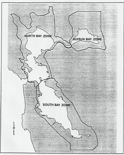
Figure 1: Wetland
designated zones of the San Francisco Bay Area
(Source: NWRC Open File 94-4, Figure 2.3, page 6.)
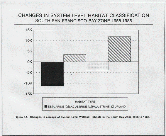
Figure 2: Changes
acreage of system level wetland habitats in the South Bay Zone from 1956 to
1985. (Source: NWRC Open File 94-04, Figure 3.5, page 33.)
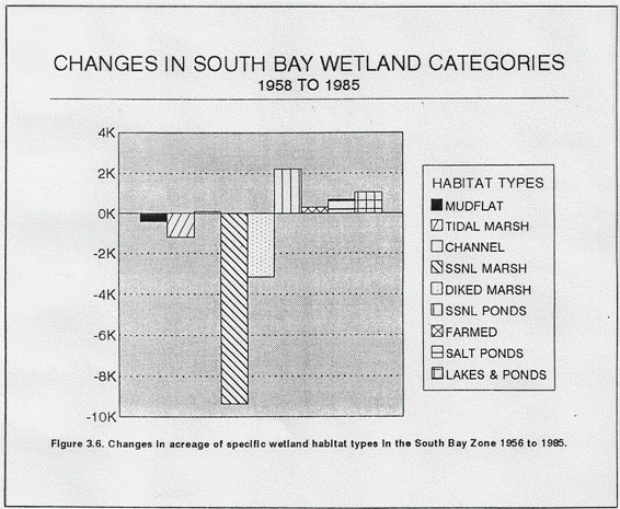
Figure 3: Changes
acreage of specific wetland groupings in the South Bay Zone from 1956 to
1985. (Source: NWRC Open File 94-04,
Figure 3.6, page 34.)
Other
wetlands types increased over time. Salt
pond acreage increased by 700 acres because ponds drained in the 1950s were put
back into production. Seasonal ponds
increased by over 2,200 acres and artificial lakes by 1,045 acres. Seasonal ponds represent seasonal salt ponds
that are now out of production or were vegetated wetlands that are now barren. Lakes represent either recreational areas or
liquid waste storage facilities. The
amount of farmed wetland increased by about 300 acres. Riparian and freshwater
habitats also increased by slightly more than 300 acres.
Comparisons
based on acreage alone may not reflect the total habitat modification occurring
in the
Since 1956, in the
Development
of
Summary
Population
pressures in the
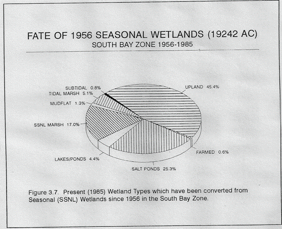
Figure 4: Acreage
of 1985 wetlands in the South Bay Zone converted from seasonal wetlands in
1956. (Source: NWRC Open File
94-04, Figure 3.7, page 37.)
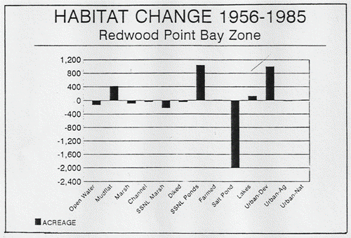
Figure 5: Changes
in acreage of specific wetlands for the Redwood Point quadrangle between 1956-1985. (Source: NWRC Open File 94-04, Figure
3.12, page 45.)
Conversion
between wetland types can lead to reduction in wildlife habitat values even
though the total wetland acreage remain the same. For example, farmed wetlands do not provide
diverse wildlife habitat. Sewage
treatment "lakes" and salt ponds were built in former wetlands and,
although these habitat may provide increased waterfowl habitat, they do not
replace the endangered species habitat that was lost as a result of
conversion.
Although
wetland loss in the
Seventeen
percent of the estuary's wetland and deepwater habitat is protected through
ownership or conservation easements for fish and wildlife resource. Forty-two percent of the protected lands are
in the South Bay Zone. The US Fish and
Wildlife Service and the California Department of Fish and Game are the largest
landowners of protected lands. Regional
park districts, open space districts, and local jurisdictions also maintain and
protect natural resource in the Bay Zone.
The
loss of nontidal seasonal wetlands is critical.
Twenty-nine percent or about 15,000 acres, of the remaining diked
baylands are slated for development over the next 20 years at a rate loss of
750 acres per year. Such declines will
lead to further deterioration of fish and wildlife resources in the region and
throughout the Pacific Flyway.
Source:
Josselyn, Michael, Lawrence Handley, Millicent
Quammen, and Dennis Peters. NWRC Open
File 94-04. The Distribution of Wetland and Deepwater Habitats in the