Barataria-Terrebonne EstuaryCocodrie Background Information
The Barataria-Terrebonne National Estuary Program
The Louisiana Universities Marine Consortium (LUMCON)
The Barataria-Terrebonne Estuary
Figure 2.1: The Barataria-Terrebonne Estuary
Deltaic Geology and the Natural Setting of Southeast Louisiana
Figure 2.2: Mississippi River Delta Lobes
Figure 2.3: New Delta Formation and Channel Deposits
Causes of Wetland Change in the Deltaic Process
Figure 2.4: Delta Lobe Abandonment and Deterioration
Barataria-Terrebonne Estuary Environments
The Importance of Coastal Marshes
Louisiana Coastal Marsh Vegetation
Other Wetland Types within the Barataria-Terrebonne Estuary
Figure 2.5: Vegetation of the Barataria Estuary
Upland Vegetation Types within the Barataria-Terrebonne Estuary
Natural Causes of Wetland and Upland Changes
Cultural Use of the Barataria-Terrebonne Estuary
Development of Southern Louisiana Culture
Cultural Use of the Delta and its Estuaries
Human Contributions to Wetland Loss
Artificial Levees and Wetland Loss
The Houma Navigation Canal and the Gulf Intracoastal Waterway
Recognition of Wetland Loss Issues
Potential Solutions to Wetland Loss
Background Information
Barataria-Terrebonne Estuary
Louisiana
The Barataria-Terrebonne National Estuary
Program
We
the people of Louisiana and the Barataria-Terrebonne estuarine basins believe
that the Barataria-Terrebonne ecosystem is a national treasure that represents a
unique multi-cultural heritage.
Furthermore, we recognize that our ongoing stewardship is critical to its preservation, restoration, and enhancement. This stewardship can only be maintained by active support of those who live in the basin, and those who use its abundant resources locally, statewide, and throughout the nation.
Acknowledging the importance of this estuary to our environmental, cultural, and economic well-being, the people living and working in these two basins believe that we should have a balanced ecosystem that includes:
We pledge to work together to develop a plan to re-establish a chemical, physical, and biological balance in the Barataria-Terrebonne estuary so that diverse plant and animal communities and human health and welfare can be improved and sustained for present and future generations.
Management Conference
Barataria-Terrebonne National Estuary Program
November
Management Conference Membership
|
Louisiana Landowners Association Coastal Conservation Association of Louisiana Coalition to Restore Coastal Louisiana Louisiana Wildlife Federation Louisiana Environmental Action Network American Sugar Cane League Louisiana Farm Bureau Federation Louisiana Seafood Management Council Louisiana Mid-Continent Oil & Gas Association Louisiana Land & Exploration Company Louisiana Independent Oil & Gas Association Greater Lafourche Port Commission Gulf Coast Canal Association American Waterways Operators Bayou Lafourche Freshwater District Jefferson Parish Environmental Department Lafourche Parish Coastal Zone Management Plaquemines Parish Government Terrebonne Parish Consolidated Government St. Charles Parish Government South Central Planning and Development Commission South Louisiana Economic Council Louisiana Science Teachers Association Louisiana Cooperative Extension Service Louisiana State University Agricultural Center LUMCON Nicholls State University Louisiana Governor's Office of Coastal Activities Louisiana Association of Levee Boards Louisiana Oil Spill Coordinator's Office |
Louisiana
Department of Education Other Active Partners Denbury Management, Inc. Hahnville High School Houma-Terrebonne Chamber of Commerce Barataria-Terrebonne Estuary Foundation LA 1 Coalition Assumption Parish Bayou Camp Program Gulf of Mexico Program Cypress Swamp Academy |
In 1990, a novel partnership called the Barataria-Terrebonne National Estuary
Program was formed. Their goal was to conduct a comprehensive study of the
environmental problems facing the Barataria-Terrebonne estuary and develop
community-supported solutions to these problems into a Comprehensive
Conservation and Management Plan (CCMP). The Management Conference -- a group of
actively involved natural resource managers, local government officials, estuary
residents, business and industry representatives, scientists, and environmental
groups -- identified seven Priority Problems confronting the estuary. The
Priority Problems can be categorized into three broad environmental issues:
Three of the seven Priority Problems identified in the planning phase are intricately linked to the issue of wetland loss in the Barataria-Terrebonne estuary � hydrologic modification, reduced sediment flows, and habitat loss/modification. A considerable amount of energy from the regional natural resource community has been allocated to this issue, and many Action Plans in the CCMP identify strategies to address these problems.
One principle mechanism to address wetland loss is coastal restoration, and includes activities such as dredged material placement, revegetation, and placement of Christmas tree structures, freshwater/sediment diversions, and shoreline protection. These coastal restoration activities have been applied to interior marshes, bay and bayou shorelines, and barrier islands. Many Barataria-Terrebonne Partners, including the Louisiana Department of Natural Resources and the Coastal Wetlands Planning, Protection, and Restoration Act Task Force, are involved in implementing coastal restoration projects in the estuary. Thousands of acres of wetlands and miles of bay and bayou shorelines have benefited from these collective activities.
The Coastal Wetlands Planning, Protection, and Restoration Act (CWPPRA), Public Law 101-646, Title III, was authorized by Congress and signed into law by President George Bush in 1990. CWPPRA directly addresses wetlands loss nationally with a primary focus on coastal Louisiana�s serious wetlands loss challenges. The Act directed that a task force consisting of representatives of five federal agencies and the State of Louisiana develop a �comprehensive approach to restore and prevent the loss of coastal wetlands in Louisiana�. The CWPPRA Task Force develops and reviews coastal restoration projects, selecting a priority list for implementation each year. Restoration projects include revegetation of marshes and beaches, barrier island restoration, dredged material placement, non-indigenous material placement, and freshwater and sediment diversions. To date, CWPPRA projects have beneficially impacted over 5,700 acres of wetlands in the Barataria-Terrebonne estuary, at a cost of approximately $58 million.
BTNEP is involved in many projects involving improving water quality, preservation of habitats and the creatures that depend upon these habitats, as well as the preservation of our unique culture. One of these is the Bayou Lafourche Initiative.
BTNEP also sponsors a number of educational projects including teacher workshops, Coastal Wetlands Workshops, Marsh Maneuvers Camp, Bayou Camp, and others. Each October, BTNEP sponsors a festival, called La fete d�Ecologie, held at Peltier Park in Thibodaux to celebrate our culture as well as ecology.
BTNEP offers activities such as storm drain marking, enviroscape and slide presentations, and vegetative plantings. A number of educational products including videos, CDs, maps, and curriculum are offered as well. For more information on these projects and activities, please see the education page on our website at www.btnep.org.
LOUISIANA
UNIVERSITIES MARINE CONSORTIUM
(LUMCON)
The Louisiana Universities Marine Consortium (LUMCON) was formed in 1979 to coordinate and stimulate Louisiana's activities in marine research and education. LUMCON provides coastal laboratory facilities to Louisiana universities and conducts in-house research and educational programs in the marine sciences.
LUMCON's primary facilities are located at the DeFelice Marine Center in Cocodrie, approximately eighty-five miles southwest of New Orleans. This location in the Mississippi River delta plain provides ready access to the most productive estuaries in the United States, to a variety of coastal environments, and to the open Gulf of Mexico. The LUMCON field camp and lab at Port Fourchon provides additional access to barrier island and bay environments.
The DeFelice Marine Center is a modern, 75,000 square foot complex of research, instructional, housing, and support facilities completed in 1986. The center includes 26,000 net usable square feet of laboratory, classroom, office, and library space. Eight laboratories are equipped with running seawater. Six additional laboratories, reserved for dry applications and instrumentation, are used for both research and teaching. A network of microcomputers and peripherals link users throughout the center. A TI link provides access to mainframe computers on the campuses of consortium member institutions.
Dormitory rooms and five apartments provide housing for up to eighty people and are available for use by students, visiting investigators, and instructors. A cafeteria/general meeting room is situated in the center of the complex, linking the housing and research/instructional spaces. A ninety-nine seat auditorium facilitates teaching activities, presentation of seminars, and the convening of conferences.
An executive board, to which the executive director reports, governs LUMCON. The executive board, which consists of the chief executive officers of Louisiana State University, Nicholls State University and the University of Louisiana at Lafayette, reports to the Louisiana Board of Regents. The center has a faculty of one scientist-administrator, six full-time research professors, one scientist-educator, and one librarian. Research staff collaborates with others in their field and conducts projects of interest on a worldwide scale as well as being of particular interest to local residents.
Recently, the state legislature linked LUMCON with BTNEP (Barataria-Terrebonne National Estuary Program), another local sponsor of this educational module. Oversight of BTNEP has been moved from the Louisiana Department of Environmental Quality to the Board of Regents. The BTNEP grant from the USEPA is now being administered through LUMCON.
The unique location of the LUMCON Marine Center near the discharges of the Mississippi and Atchafalaya Rivers and within the expansive coastal wetlands of Louisiana provides numerous research opportunities. LUMCON faculty conducts comparative studies across the United States and worldwide in similar environments to provide insight into the problems of coastal Louisiana. Five general research themes form the basis of research by resident faculty and staff in collaboration and cooperation with faculty and students of member universities.
The Mississippi and Atchafalaya Rivers drain 41% of the continental United States, delivering fresh water, sediments, nutrients and chemical elements to the adjacent continental shelf.
Specific research programs address:
Human and Industrial Impacts
Some of the most intense oil and gas extraction activities in the world occur within Louisiana's wetland and coastal habitats and offshore environments.
Major studies have focused on:
Other land use activities within the Mississippi River watershed (agriculture, urban development) contribute to increased levels of nutrient loading in coastal habitats. Several research studies are being conducted in the Gulf of Mexico and in the estuaries of Barataria and Terrebonne Bay:
Processes Influencing Coastal Change
Wetland loss and barrier island erosion continue to be major problems in the Louisiana coastal zone with coastal land loss rates estimated at 25 mi2 yr-1. Marsh management in Louisiana has been specifically evaluated in terms of its impact on marsh sedimentation, and studies continue to determine the efficacy of various marsh restoration measures. LUMCON researchers work with the Louisiana Coastal Conservation and Restoration Task Force in designing and implementing individual projects, and in evaluating the feasibility of restoration measures.
Commercial and recreational fisheries are key components of Louisiana's environmental and economic resources. Management of these fisheries and the food webs that support them are essential in the presence of environmental deterioration including coastal land loss and nutrient enrichment.
Several research programs focus on the early stages of fish larvae:
The fate of carbon and the importance of the ocean as a carbon sink are issues being addressed by LUMCON researchers and their colleagues through avenues of zooplankton and bacterial processes and via the collection of fluxed materials in the water column and at the seabed.
Research programs similar to prior studies of recruitment and dispersal mechanisms in coral communities of the Great Barrier Reef are planned for corals of the Gulf of Mexico (Florida Keys, Flower Garden Banks and northern Mexico).
LUMCON employs two educators full-time to educate the general public about LUMCON and its missions, Louisiana�s vast coastal resources, how LUMCON has used resources, and threats to future resource conditions. Students have the opportunity to spend time in the estuary learning about estuarine productivity and issues (like land loss) through observation. Students also visit the working areas of the lab to help them understand how science and LUMCON scientists have contributed to current understanding of Louisiana coastal environment. Such interaction helps LUMCON to discuss how science changes the way people see the coastal and estuarine environments.
The K-12/Public Education Program offers guided field trips to educational groups from schools, churches, scouting and civic organizations. These field trips range from tours of LUMCON and laboratory investigations to expeditions into area marshes, bays and barrier islands using LUMCON�s various research vessels (from canoes to the Research Vessel Acadiana). LUMCON is currently revising its website to illustrate the complete menu of field trip offerings (www.lumcon.edu).
This program also just completed its first week-long summer camp for middle and high school students in August 2001. The program was a huge success and will be repeated in the future. Future growth in the public education programs will include teacher workshops and enhancements to the website that will make it easier for teachers to use LUMCON resources in their classrooms. We are developing classroom activities that can be used to help teacher communicate science purpose, method, inquiry and creativity in classrooms. Once the students are familiar with what is offered on the website, they can come to LUMCON for a field trip during which they can try all their new skills in a new environment with scientific equipment.
The University Education Program offers marine science courses to college students throughout the state all over the state. There are several classes held during the academic year through distance learning technology. There are also classes held every summer that students can attend at LUMCON. These offer the local field environments, LUMCON�s laboratory facilities, an intense work schedule conducive to intense learning, and lots of time to interact with fellow students and course instructors. After offering courses on an irregular schedule for many years, LUMCON is standardizing its offerings so students will know what courses to expect in a given year. Course listings and other information are available on the LUMCON website (www.lumcon.edu).
Barataria-Terrebonne Estuary
Cocodrie,
Louisiana
The
information in this background was compiled from several sources. The background
information provided in the Avery Island/Weeks Bay and Golden Meadow WETMAAP
modules was particularly helpful in compiling cultural history. The
Barataria-Terrebonne National Estuary Program (BTNEP) documents listed in the
references provided almost all of the figures. Much of the information about the
Houma Navigation Canal (HNC) and the Gulf Intracoastal Waterway (GIWW) came from
Internet research on the Texas State Historical Society website, and the Houma
Courier website (HNC)
Note: The
Geographic Summary is a compilation of information from existing sources and is
intended to provide a brief synopsis of the Barataria-Terrebonne program,
estuary, LUMCON, and Cocodrie site. It is not meant to be an in-depth treatise
on the geography and background of the area.
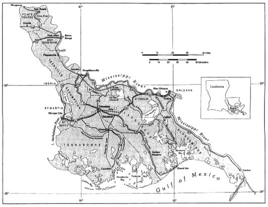
The Barataria-Terrebonne Estuary of southern Louisiana is flanked by two of the largest rivers in the United States, the Mississippi on the east edge and the Atchafalaya on the west edge (figure 2.1). The Barataria-Terrebonne estuary includes all the land and water area in the Barataria and Terrebonne basins (watersheds) that drain into the Gulf of Mexico. An estuary is a place where freshwater from the land mixes with saltwater from the ocean. An estuary includes open water, wetland vegetation, and uplands. The estuary water body is partially constrained at its mouth.
Located in Southeast Louisiana, the Barataria-Terrebonne Estuary is part of the Mississippi River Delta that has been forming over the past 7500 years. The Barataria-Terrebonne Estuary is the location of some of the most rapid loss of wetlands observed in the world today. Many processes related to deltaic formation contribute to the natural process of wetland loss.
The focus for the Cocodrie site is to examine vegetation changes resulting from economic development, especially navigation channels. Natural change in wetland vegetation continues within the estuary, but is accelerated by human development.
This geographic summary is divided into two parts; the first summarizes the natural process of deltaic geology as it pertains to coastal Louisiana and describes the natural processes that are important in habitat loss.
The
second part of this Geographic Summary briefly discusses cultural use of the
estuary, the value of wetlands, and some of the ways that humans have responded
to the problems of wetland loss. Potential solutions are suggested for slowing
wetland loss and restoring lost estuarine habitats.
(Source: BTNEP Publ. No. 20, Status
and Trends of Hydrologic Modifications, Reduction in Sediment Availability, and
Habitat Loss/Modification in the Barataria-Terrebonne Estuaries Systems,
Denise J. Reed, editor.)
Figure 2.1: The Barataria-Terrebonne Estuary is
bounded by the Mississippi River on the east and the Atchafalaya River on the
west.
Deltaic Geology and the Natural Setting of Southeast Louisiana
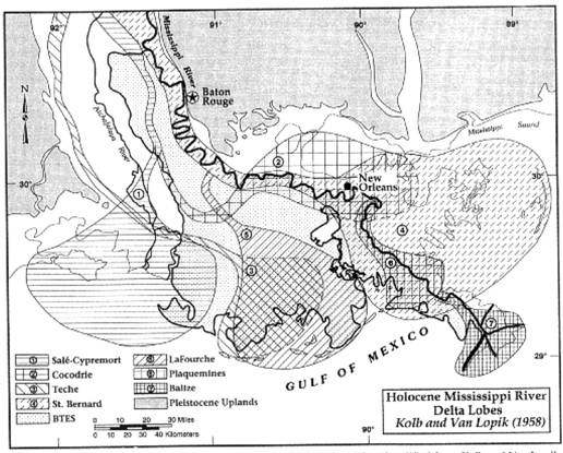
The Mississippi River formed Southeast Louisiana and continues to mold it. The combined flow of the established Mississippi distributary channels and the newer Atchafalaya distributary channels averages over 15,000 cubic meters of water per second (cms). Its maximum flow during the spring flood can exceed 57,900 cms. This water drains from thirty-one states (41% of the continental U.S.) and two Canadian provinces. The Mississippi River and all its tributaries carry eroded sand, gravel, soil, and organic material, and decomposed detritus into the Gulf of Mexico. The river carries up to 1.5 million metric tons of this sediment daily through the Atchafalaya and Mississippi river channels. Over the past 7500 years the Mississippi River has built the present southeastern coast of Louisiana as a series of overlapping delta lobes (figure 2.2). To understand the estuary, it is necessary to understand how the Mississippi River formed this land.
The river builds land by depositing its sediment load. As water slows down, it cannot continue to transport all the sediment it was carrying. The sediment that cannot be carried will fall out and be deposited on the bottom of the river channel, on the natural levee, or elsewhere on the floodplain. By the time the river gets to the delta, very coarse sediment, like boulders and cobbles, have fallen out within the river channel. Only finer grained gravel, sand, silt, and clay remain in the sediment load of the river. As a result, the Mississippi River delta deposition is composed, primarily, of the finer sediments.
The river builds land in two directions. Every spring the river drains the watershed of the winter�s snow melt and spring rains, causing higher water levels in the river. If the water level gets high enough to overflow its banks, the river will flood adjacent lands. The water slows down as it leaves the channel and develops a deposit known as a natural levee (figure 2.3). Some sediment is carried beyond the natural levee with deposition of this sediment at lower elevations on the floodplain or within the delta.
(Source: BTNEP Publ. No. 20, Status
and Trends of Hydrologic Modifications, Reduction in Sediment Availability, and
Habitat Loss/Modification in the Barataria-Terrebonne Estuaries Systems,
Denise J. Reed, editor.)
Figure 2.2: Southeast Louisiana is made up of land
deposited by the Mississippi River as a series of successive delta lobes.
(Source: Gosselink, J.G. 1980. Tidal Marshes: The Boundary Between Land and Ocean. Washington, D.C.: U.S. Fish and Wildlife Services, Biological Program. FWS/OBS-80/15.)
Figure 2.3: The process by which a delta builds its lobe includes deposition along side of the channel as well as extension into the ocean.
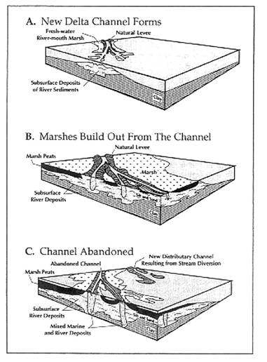
This deposition at lower elevations (near sea level) will continue to accumulate sediment until the sediment surface reaches sea level and new land forms in the delta. This new land will be within the intertidal range, between high tide and low tide, and may become vegetated with marsh grass. The river deposits sediment year-round at the river or channel mouth where the freshwater meets saltwater from the Gulf of Mexico. As sediment accumulates higher, when they reach sea level, they become flats; when the sediment deposition becomes even higher, it becomes land. In the process of land building in the delta, the river channel is lengthened and the delta lobe is extended into the Gulf.
Each of the Mississippi River delta lobes was a site of active river deposition for about 1000 years. The river will use the steepest gradient possible to reach sea level. As the river builds a delta lobe, the channel gets longer, causing the gradient of the channel to decrease. At this point, the lobe extends farther out into the Gulf than most of the surrounding land. As a result, there are now several routes to sea level that offer a more favorable (steeper) gradient for channel flow. This causes the river to form a new channel and potentially form a new delta lobe, which usually happens over a period of years.
The river finds a new steeper channel during the spring flood when it carries the most water and thus has the greatest power to cut a new channel in unconsolidated delta sediments upstream from the active lobe. As the river cuts a new path to the Gulf, the river uses both the existing channel of the active lobe and the new channel for a number of years. Water flowing through the new channel carries sediment and begins to deposit a new delta lobe the same way as the first channel. The percentage of flow traveling downstream through the new channel increases until it carries more of the water (and sediment) than the previous channel. The new channel then becomes the active lobe, building land in a new direction, and adding to the river�s delta or developing a completely new delta lobe (figure 2.3).
As sediment is deposited within the delta lobe and into the Gulf, the sediments become exposed to air during low tide. Saltwater is not present on the surface of these newly formed sand and mud flats at low tide, but they will be covered by the high tides. Deposits that are exposed at low tide and submerged at high tide are called intertidal flats.
As land develops in the intertidal zone, vegetation will begin to colonize the flats. This is the development process of tidal marsh.
While the Mississippi River is constantly depositing sediments in its existing delta lobe, the river water entering the Gulf of Mexico is fighting against the movement inland of seawater from currents and wind. The waves created by the wind erode the delta deposit and will re-shape the delta lobe temporarily. The river will continue to deposit more sediment to extend the delta lobe and maintain its shape (figure 2.4a). As the main channels lose their water and sediment loads to diversions into new distributary channels, the waves become the dominant force shaping that part of the coastline because the amount of sediment deposited is less than the amount of sediment eroded by the waves (figure 2.4b). The waves erode the delta lobe landward and will re-shape the coast.
Marshes are vulnerable to erosion from waves and cannot survive, except where they are protected, as in the area behind barrier islands. In addition, marshes need a continuous supply of sediment to allow them to maintain their intertidal elevation while delta deposits subside. In the absence of deposition, the frequency of marsh inundation by tidal water may increase. When this happens, the marsh plants will become stressed and potentially die, leaving the mudflat that the marsh was on vulnerable to erosion by water movement.
Salt marshes can only thrive when they are at an intertidal level. The weight of the sediment added to the delta deposit makes that deposit and the surface of the land sink, or subside. As the water within the sediments is removed, the grains compact to take up less space. As a result, the sediment takes up less space through compaction and the surface sinks. The marsh on the surface of those sediments actually sinks in this process, known as subsidence. Subsidence happens continually in all of the delta lobe deposits, but in the active delta lobe, the river continues to deposit additional sediment on
(Source:
Pemland, S. et al. 1988. Transgressive depositional systems of the
Mississippi Delta plain: A model for barrier shoreline and shelf development.
Journal of Sedimentary Petrology. 58.6)
Figure
2.4: A delta
lobe proceeds through a series of steps from the time it is first occupied by
the river to its abandonment and deterioration.
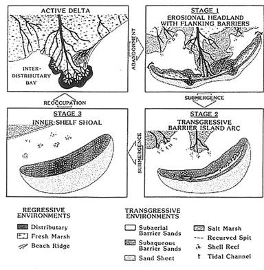
top of the existing marsh. If the amount of sediment deposited is equal to or greater than the rate of subsidence the marsh remains at an intertidal level and stays healthy. In an abandoned delta lobe, the amount of sediment deposition is less than the rate of subsidence; the marsh surface subsides below the intertidal zone, and the marsh will become stressed. Marshes the farthest away from any distributary channel have the fastest rate of subsidence because the amount of sediment deposited is always less farther away from the channels. In the Barataria-Terrebonne Basins, these inter-distributary basins show the greatest amounts of wetland change. As the land surface and marsh subside, open water covers the area (figure 2.4c). Increased areas of open water allow erosion at the edge of the existing land and marsh to continue from increased wave action. Subsidence at the interior of the inter-distributary basins will continue, and the shoreline will become a system of retreating marshes and barrier islands. Ultimately, even the barrier island will be eroded away, leaving only a submerged shoal in its place (figure 2.4d).
The
Mississippi River has deposited at least seven separate delta lobes since the
end of the ice age. The Modern or �Bird�s Foot� Delta has been active for
about 750 years. Since the early 1800s, an increasing amount of water has been
flowing from the Mississippi River into the Atchafalaya channel. The Atchafalaya
channel is the shortest route to the Gulf of Mexico and has a steeper gradient.
The Atchafalaya River is building an active delta and could become the active
delta of the Mississippi River in the future. The Barataria-Terrebonne estuary
is located within the Lafourche lobe, which was the active delta lobe before the
Modern Delta (figure 2.2).
These three different delta lobes, the Modern, Atchafalaya, and Lafourche, illustrate different stages of the delta building cycle.
The present channel of the Mississippi River is still building some land. The channels of the active Modern Delta extend miles farther into the Gulf of Mexico than any other current channels of the historical delta complex. This means that water flowing into this channel must travel a greater distance along a more gentle gradient. In this situation, the river�s energy is not sufficient to transport the amount and size of sediment that it can along a steeper gradient. As a result, the river will seek the shortest route to the Gulf because it is the steepest gradient over which to transport more sediment load and sediment of larger grain size.
The Lafourche Delta clearly illustrates what happens when the channel is abandoned and no longer supplies a lobe with sediment and freshwater. The barrier islands at the edge of large bays were initially at the outer edge of the delta lobe with marsh that stretched landward behind them. The shoreline is ragged as different rates of subsidence and exposure to wind and wave erosion have caused the breakup of the marsh and wholesale land loss.
The Atchafalaya channel is building land at an increasing rate. The Atchafalaya Delta is the location of the most rapid land gain in the nation. Nearby marshes and swamps also receive periodic flooding to replenish sediment. These habitats do not show the same degree of degradation as marshes and swamps in the Barataria-Terrebonne estuary.
The Barataria-Terrebonne Estuary contains environments ranging from uplands to barrier islands, fresh and saline marshes, forested wetlands, and open water. On the 1988 habitat map of the Barataria-Terrebonne Estuarine System, which is the southern portion closest to the Gulf, 60 % of the area covered by the estuary was open water. Salt and freshwater marshes covered 29%, forested wetlands covered 6%, and uplands covered 4%.
The Importance of Coastal Marsh
Vegetation contributes to maintaining the marsh against erosion in several ways. First, the plant roots trap sediment, contributing to increased deposition. Second, the plant roots hold existing sediment in place, making it more difficult for waves to remove surface sediments. Third, the plants slow the water moving into the marsh, making it more difficult for the flowing water to remove existing sediment. The stabilizing properties of the plants and their root systems in the marsh contribute to protecting locations more inland from the high energy of storms. Marshes act as a buffer by absorbing wave energy and by slowing water movement and by retaining some of the water from the waves. As a result, a storm moving inland across large areas of marsh could be less dangerous because the wind velocity and intensity are decreased and the storm surge is reduced in height.
Marshes provide a valuable wildlife habitat. They serve as shelter, breeding ground, and nursery for many of the most important commercial fisheries, including shrimp and crab, redfish, and speckled trout. In addition, the food webs of the marsh and surrounding water bodies are highly productive, so the environment offers abundant food sources to animals. As a result, many birds, furbearers, and reptiles live in the marsh as well.
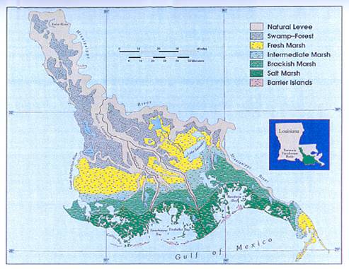
The plants that colonize a marsh are suited to the salinity of that marsh�the balance of freshwater from land and saltwater from the Gulf varies throughout the delta. Coastal marshes occur as broad bands of salt, brackish, intermediate, and freshwater vegetation lying in sequence parallel to the Gulf coast from the ocean to land (figure 2.5). These communities can be characterized by the following species associations: salt marsh (Spartina alterniflora, Distichlis spicata), brackish marsh (Spartina patens, Spartina alterniflora), intermediate marsh (Spartina patens, Vigna sp., Sagittaria lancifolia), and fresh marsh (Panicum hemitomon, Sagittaria sp., Eleocharis sp.).
Most of the
Barataria-Terrebonne basins are covered with marsh and open water. However,
large areas of forested wetland are found landward of the freshwater marshes in
the upper parts of the basins. Forests of two types are found: freshwater swamps
and seasonally flooded bottomland hardwood forest. Bald cypress (Taxodium
distichum) and water tupelo gum (Nyssa aquatica) dominate freshwater
swamps; these occur with red maple (Acer rubrum) and buttonbush (Cephalanthus
occidentalis). Hardwood species including several oak species (genus Quercus
sp.), green ash (Fraxinus pennsylvanica
(Source: Chabreck, R. H., and R.G. Linscombe. 1988. Louisiana Coastal Marsh Vegetative Type Map, 1988, Louisiana Department of Wildlife and Fisheries. Baton Rouge. )
Figure
2.5: The
wetlands of south Louisiana occur as board, roughly parallel bands of vegetation
that are tolerant of differing conditions of flooding and salinity.
var. lanceolata) and red maple (Acer rubrum) dominate the bottomland hardwood forest. These two types of forests occur about equally in the Barataria-Terrebonne basin.
Barrier islands in Louisiana are typically very low in elevation and do not support large maritime forests. Barrier island vegetation is characterized by a number of species including beach morning glory (Ipomoea stolonifera), wax myrtle (Myrica cerifera), buckbush (Baccharis halimifolia), and Spartina patens. The marshes on the landward edge of the islands include typical salt and brackish vegetation, predominantly oyster grass (Spartina alterniflora), Batis maritima, Salicornia sp., and the salt-tolerant scrub-shrub black mangrove (Avicennia germinans).
Upland Vegetation Types within the Barataria-Terrebonne Basins
Uplands, areas of high elevation with slope and non-hydric soil characteristics, are usually not flooded for extended periods of time. These include natural levees, uplands on barrier islands and upland areas in the upper or northern portions of the basins. Typically, these upland areas are places where delta lobes have overlapped for several thousand years providing long periods of sediment deposition in the same location. For example, natural levees found along large bayous, such as Terrebonne, Grand Caillou, and Petite Caillou, become high enough to support the forested and scrub-shrub vegetation types.
The uplands support coastal upland forest, plant associations dominated by live oak (Quercus virginiana) and water oak (Quercus nigra), with hackberry (Celtis spp.) and other species. Buckbush (Baccharis halmifolia) and marsh elder (Iva frutescens) are the dominant shrubs, with considerable dwarf palmetto (Sabal minor) present.
These areas are the most susceptible of all deltaic environments to being cleared for habitation. However, they are also susceptible to subsidence, and barrier erosion, and increasingly, as the fresh marshes deteriorate, they are subject to saltwater intrusion.
Natural Causes of Wetland and Upland Change
The Mississippi River, flowing downstream toward the Gulf, carries the drainage of its whole watershed. Discharge is not the same throughout the year. It is greatest in the spring when snows from mountains in the northern parts of the watershed melt and along with spring rain flow to the Gulf. During the spring discharge, the river contains more water than its banks can hold, causing floods along the sides. As soon as the water escapes the deep part of the channel, it loses the momentum of the river flow and slows down very quickly. Moving more slowly, the water drops its sediment load right next to the bank, increasing the height of the bank to form what is called a natural levee. As the floodwaters slacken, the higher elevation areas are left high and dry. Natural levees form along the sides of all streams, from the Mississippi River and Bayou Terrebonne to the tidal channel.
Subsidence is a continual process in the delta. The Mississippi River has dropped tons of sediment into the shallow waters of the Gulf of Mexico, leaving a deposit over a kilometer deep. The weight of this deposit causes deformation of the earth�s crust and moderate sinking of the deltaic deposits. Sediment that forms the deposit is dropped haphazardly, leaving space for air, water and organic debris. Over time, organic matter decomposes leaving more gas and water. Through the application of heat and pressure from tons of sediments, the grains are forced to compact and displace gases and water. Through this process the sediment settles and takes up less space. This results in more rapid sinking of the surface of the sediment. It is most obvious in the marshes, which are able to survive only in a narrow range of elevations. Subsidence can cause marshes to sink at a rate of approximately 1cm/year in southeast Louisiana.
Subsidence is balanced in a growing delta lobe by annual spring flooding of the Mississippi River that can deposit enough sediment to make up for sinking. In an abandoned delta lobe, interdistributary basin subsidence contributes to the formation of bays behind barrier islands and higher rates of land loss.
Saltwater intrusion occurs when saltwater from the Gulf moves into areas that have formerly been influenced by freshwater. As saltwater intrudes into a fresh marsh, the habitat will be altered as the plants and organisms that once thrived in the freshwater marsh cannot survive in saltwater. If the intrusion of saltwater is gradual enough, plants and organisms that can survive in a saltwater habitat begin to invade and grow, eventually establishing a brackish marsh. If saltwater vegetation does not replace the freshwater plants, the area will become exposed mud flats, and they are likely to revert to open water. This process is common in an abandoned delta lobe where the discharge of the river decreases or even in areas of the modern delta where freshwater is diverted or maintained within existing channels.
In a growing Modern Delta, the water discharging from the river has more influence on the shape of the delta lobe than the waves because there is a huge volume continuously entering the Gulf to minimize and reverse the effects of the waves. The sediment load is dropped along the sides and at the end of this channel, shaping the bird-foot delta associated with southeast Louisiana.
In a deteriorating delta lobe, the river discharge decreases to a trickle over a number of years. The river discharge of sediment is no longer sufficient to offset the erosion by the waves and to reshape the smooth arc-shaped beaches waves form.
Several animals that use the marsh as habitat graze on the plants growing there. These include various species of ducks as well as the native muskrat. Bird populations are only active in the delta during winter, but furbearers are present year-round in the marsh. In addition to uprooting marsh plants for their tender roots, muskrats make their houses by burrowing through the sediment of marshes. Both of these activities decrease the stability of the marsh substrate and make it more susceptible to sediment loss. Sometimes, a large population of muskrats will eat all of the vegetation in an area (an eat-out), making the former marsh particularly vulnerable.
The people of southeast Louisiana are tied to their environment--mostly wetlands. They depend upon the wetland for cultural preservation and economic prosperity. They have traditionally used marsh plants for cord and twine, as well as nutrition. Small animals provide hide and fur for clothing. Materials for housing have been readily available; some of the most commonly used are mud, shell, palmetto leaves, and timber from the freshwater swamps. Fish, shellfish, small mammals and even alligators provide an abundant food resource base for subsistence and economic development.
The availability of resources, protected inlets, estuaries, and the accessibility of waterways for transportation were among the many reasons people settled along coastal areas. People were able to navigate the bays and bayous, to move between the productive delta environments, the Gulf, and inland cities. They built homes on levees and any other land that might be high enough to avoid regular flooding and also began to cultivate crops on these well-drained higher lands.
Industry plays an important role within the Gulf of Mexico and dramatically affects the Barataria-Terrebonne Estuary. At the turn of the twentieth century, ancient delta deposits offshore of the active Mississippi River Delta containing oil, natural gas and sulfur were discovered. The extraction and mining of the deposits attracted people to the region and changed the delta. The increased exploration and production of mineral resources resulted in the need for artificial channels making mineral extraction profitable and simplifying travel through wetlands. Natural channels meander, and continue to curve with age. Before large-scale mineral production development, individual trappers and fishermen might establish a straight path through the marsh to their most productive locations. Large-scale development of natural resources brought in the machines and technology to move through and over the marsh and to dredged numerous straight channels for boat traffic and pipelines.
In recent years, humans have begun to evaluate the values of the delta beyond the resources that can be harvested. People enjoy spending time in the delta�s swamps and marshes and on barrier islands because these are appealing places and these natural environments provide individuals with peace, beauty and solitude. A wide variety of birds and fish, and vegetation habitats offer aesthetic appeal hugely important to many different types of people.
Besides the aesthetic value, people recognize the practical value of wetlands. Local, regional, and national programs promote awareness of wetlands as natural measures to protect and aid human settlement. The Barataria-Terrebonne Estuary provides protection to more densely populated cities such as New Orleans by absorbing much of the force of storm winds and waves. As a storm passes over marshes, it is further weakened reducing the effects of flooding and wind.
Wetlands enhance water quality by filtering pollutants from the water and provide a source of ground water recharge.
Native Americans have been around since before the first delta lobe of the Mississippi River became active approximately 7500 years ago. As the river began to form the delta, these occupants utilized the plentiful coastal resources available throughout South Louisiana. Deltaic waterways provided easily accessible transportation routes and high ground on the natural levees. As a result, land along bayous, rivers, and streams were the preferred sites for settlement. These early settlers recognized the quality of the soil and planted crops to supplement the wild food sources. By the time the first Europeans arrived in the estuary, the resident Native American population was well over 10,000 people. These residents showed the Europeans that it was possible to survive in a wetland area that many white people regarded as an inhospitable wasteland. There are still people of native descent living in the estuary.
Immigrants came from Europe and Asia. Southeast Louisiana�s environments offered physical isolation and security to people who were escaping oppressive environments of religious and political persecution. Immigrants settled in this part of North America because the Mississippi River Delta provided a coastal environment similar to the ones they were leaving.
The first immigrants to settle in the estuary were a group of Catholic French Canadian refugees who were driven from the Acadian region of Canada by the English in 1755. These people became known as Acadians, a name which has been contracted to �Cajuns�. Ownership of south Louisiana transferred from the French to the Spanish, back to the French and finally to the United States through the Louisiana Purchase. During this time, Germans, Isle�os (Canary Islanders), Austrians, Slavs, Chinese, Filipinos, Englishmen, Irishmen, Latin Americans, African Americans, and Italians joined the Cajuns. In recent years, a large number of Vietnamese have arrived in this part of the estuary. Each set of immigrants contributed to the developing culture of Southeast Louisiana.
The people who settled in this area over the years have come from every part of the world. The local blending of beliefs and ideals has created a diverse culture with worldwide influences. This estuarine culture, formed by a mix of ethnicities dependant upon the wetlands of Louisiana, is one of the greatest resources we are in danger of losing if the present pattern of marsh loss be abated.
Development of Southern Louisiana Culture
Many of the roads in this part of the delta stretch along the high land next to bayous. Long, linear land parcels with houses built on stilts, perpendicular to major roads illustrate the continuing influence of both the French long-lot system of defining land ownership and the Filipino practice of building a house off the ground to avoid problems with flooding.
European settlers took full advantage of the region�s resource base. As a result, many cultural components survive-dispersed and overlapping settlements, linear communities, grid cities, plantations, folk houses, boats, above-ground graveyards, and other elements of the region�s material culture. To some, these elements are not important; others see such elements as links to their heritage.
Early settlers developed subsistence lifestyles as farmers, fishermen, hunters and trappers. These people moved as the deltaic environments changed. Later settlers began managing the region�s natural waterways to prevent change and guarantee the viability of the settlements rather than moving settlements.
As early as the 1730s, French Creoles began to exploit the deltaic wetlands. Initially, the region�s natural commodities attracted them, particularly its timber and shell resources, which were used for construction and roads. The timber came from the area�s vast bald cypress (Taxodium distichum) and tupelo gum (Nyssa aquatica) forests. The shell used by the French Creoles was derived from the wetland�s numerous Native American shell middens--refuse mounds that mark many of the archeological Native American sites throughout Louisiana. The clam Rangia was a primary food source for the Native Americans in this area, and the shell is a major component of many middens. The Creoles burned the shells to convert them to lime for use in construction (Pearson et al, 1989A; Pearson et al. 1989B).
Originally, the local economy was subsistence driven. Later, cash crops became important, and harvesting resources became an industry. The agricultural production of sugarcane, cattle, and rice; the extraction of sulfur, oil, and natural gas; the harvesting of fresh-and saltwater fisheries; and the trapping of mammals and reptiles developed in response to national and international market demands. As the region�s population expanded, rural settlement clusters developed their own economic niche. Each community acquired its own distinctive employment identity. Agricultural centers shifted to oil and gas support. When oil and gas production declined in the 1980s, many ports that supported these industries shifted to seafood processing. The survival of these communities attests to the will of the people and their love of the land.
Since the 1970s, oil and gas development has gone through several periods of �boom and bust�. Each time, the local residents were able to return to their inherited subsistence vocations of farming, fishing, shrimping, and trapping until the oil and gas industry demand returned.
To succeed and exist
in this dynamic and sometimes inhospitable environment, the population developed
and utilized innovative engineering techniques, unconventional wisdom, and
unique cultural occupancy patterns--always with an eye toward maximizing the
region�s renewable resource base. Unfortunately, losses of habitat are
beginning to threaten these livelihoods as well. As a result, local governments
has invested in barrier island research and restoration, water-control
structures, levee fortification, locks and gates on key natural and engineered
waterways, extensive pump systems and forced drainage projects, canals and
ditches to improve flood control, and other public works projects.
Humans have changed the way water flows through the delta. The construction of levees and canals has produced hydrologic changes that have contributed to wetland loss, although these activities were only meant to help people live more easily and increase economic prosperity in the deltaic environments of southeast Louisiana. The natural causes of wetland loss are continually working to change the landscape of south Louisiana. However, human activities are causing loss of wetlands at a greater rate than natural causes working alone.
The Mississippi River deposits natural levees by the process described earlier. People have adapted this process to build artificial levees that protect property from tidal and seasonal flooding. Early settlements of the region were located on natural levees adjacent to the Mississippi River that were less likely to flood. As settlement continued, settlers expanded land use and settled further back from the natural levees in areas that were more susceptible to flooding. At the same time, subsidence continued to reduce elevation of the limited amount of high land. Later settlers built artificial levees along the Mississippi River to protect themselves from floods. Initially, these levees were small and localized to protect an individual landholder. This changed after the 1927 Mississippi River flood.
In 1927, there was an unusually large amount of rain during the spring season when the snowmelt drained down the river into the Gulf. The flood that year covered a much larger area than usual. During this event, water in the river rose catastrophically, an extremely large area of the Mississippi Valley remained flooded for weeks, many people died and thousands of people lost their homes. After that, Congress charged the U.S. Army Corps of Engineers with building and maintaining a continuous levee along the Mississippi River from Missouri downstream past New Orleans. The height of the levees containing the Mississippi River has gradually increased from three feet in the early 1700s to about seventeen feet today.
In 1950 people became aware that the Atchafalaya River was capturing an increasing percentage of the Mississippi River. If the Mississippi River started using the Atchafalaya River as its active channel, then the current lobe would be abandoned. This change could lead to additional land loss as the Gulf erodes delta land that no longer receives freshwater and sediment from the river. In addition, industry and communities along the Mississippi River would loose fresh water for drinking, industrial use, and navigation. For this reason, Congress authorized the Army Corps of Engineers to build the Old River Control Structures in 1951. These structures regulate the combined Mississippi and Red rivers ensuring that 70% of water flows down the Mississippi River and 30% travels down the Atchafalaya.
Hurricane protection levees are also important to Terrebonne and Lafourche Parishes in the Barataria-Terrebonne estuary system because the land area is only a few feet above sea level. Storm surge from the gulf and potential flooding from rainfall are constant dangers facing residents. In the past approximate thirty-five years, the residents of these parishes have experienced coastal flooding from hurricane surges several times, and both parishes are constructing or planning to construct large levees as public works projects designed to protect residents from hurricane storm surge. The hurricane protection levee planned for Terrebonne Parish would lay several miles inland from the Louisiana Universities Marine Consortium (LUMCON) complex.
Artificial
Levees and Wetland Loss
Artificial levees that confine the Mississippi River to its channel work against the natural cycle of delta lobe growth and abandonment. They restrict the flow of sediment to marshes behind levees, which increases the impact of subsidence. They also restrict the flow of freshwater into marshes, which can promote saltwater intrusion. By limiting freshwater and sediment delivery, levee construction on the Mississippi River has increased the rate of degradation of the abandoned Lafourche Delta lobe in the Barataria-Terrebonne Estuary system. Even though it is not the dominant lobe, parts of this area are likely to flood frequently during those years of exceptionally high spring flooding.
During periods of high river flow, the sediment load remains in the main channel of the Mississippi River, which carries it out to the edge of the shallow continental shelf close to the deeper water of the Gulf of Mexico. Much of the sediment that would formerly have been deposited by spring flooding in the delta lobe is now sent into the deep water where it will not accumulate to form any exposed land on a human time scale.
Terrebonne Parish wetlands do not show clear evidence of damage by Mississippi River levees during the time for available aerial photography. However, some scientists believe that the loss of sediment and freshwater through levee construction since the 1930s is the single biggest cause of wetland loss in southern Louisiana.
Marsh channels curve
and do not run in straight lines. Early residents living in isolated locations
decreased travel time by straightening channels heading to frequently visited
spots: relatives� houses, good fishing and trapping spots, and pathways to
town. Later, when oil was discovered in the marshes, companies began to
construct canals that facilitated exploration and production. New machinery
allowed indiscriminate canal construction. Little value was attached to the
marsh, and the vulnerability of wetlands was not recognized. Between the 1940s
and 1970s, the oil and gas industries dredged canals as needed to transport
people and equipment to drill sites, to establish pipelines, and to transport
others goods for commerce.
Canal construction causes marsh loss in several different ways. Marsh that is removed during channel construction is lost to open water. Dredging a canal leads to saltwater intrusion. Boat traffic through the marsh usually makes a wake, in which water moves quickly enough to remove sediment from the new marsh edge. This widens the channel and makes it easier for salt water to travel farther upstream in the canal.
The sediment that was dredged from the channel (spoil) is placed next to the channel causing a loss of marsh and an increase in upland vegetation. Adding spoil to the marsh surface next to the canal raises the marsh out of the intertidal zone so it cannot support wetland vegetation. This higher spoil bank also can impede the hydrology and salinity of the marsh behind the spoil bank causing changes in vegetation types.
Sometimes canals have been constructed on all sides of a marsh, surrounding the marsh with spoil banks. These marshes are �impounded� because water flow is restricted on all sides. By restricting water flow, spoil banks cause the marsh to remain either flooded or drained for long periods of time. Neither of these situations is conducive to vegetation vigor when the marsh is removed from the regular tidal cycles of flooding and draining. Plants die and the marsh reverts to open water. Minimizing the tidal flow into the marsh also limits the amount of sediment that can be delivered to the marsh surface. In the absence of adequate sedimentation, the marsh subsides and may revert to open water.
The Intracoastal Waterway is a long canal that roughly parallels the Gulf coast. Albert Gallatin, U.S. Secretary of the Treasury, first proposed its construction in 1808 as a way to link commerce from the Grand River to Boston, Massachusetts. The Gulf Intracoastal Waterway (GIWW) is the name of the segment along the Gulf of Mexico from Brownsville, Texas to Fort Meyers, Florida. The channel was financed by the federal government and built by the U.S. Army Corps of Engineers to a depth of 12 feet and width of 125 feet. Traffic along its corridor includes recreational boats as well as large traffic carrying goods between the coastal ports and service centers. Vessels carry petroleum products, iron and steel, building materials, fertilizers, liquid sulfur and other products that must be shipped in large quantities. The GIWW provides a route for the commercial fishing fleet and oil-rig work boats to use on their way to the Gulf of Mexico.
In southeast Louisiana, near the Mississippi River Delta, the GIWW runs about thirty miles inland of the Gulf of Mexico. The route from the Gulf to the GIWW requires travel through long, meandering bayous, many of which are heavily populated with residences and signs requesting that boat traffic try to avoid making a wake. Several straight routes from the GIWW to the Gulf have been built. One of these, the Houma Navigation Channel (HNC), connects Houma, the largest city in the Barataria-Terrebonne Estuary System, with the Gulf of Mexico. The U.S. Army Corps of Engineers built the HNC in 1962 to a depth of 15 feet and a width of 150 feet.
Wetlands were lost where the canal was dredged, along the side where the spoil was placed, and behind the spoil bank where changes in marsh water flow led to losses of vegetation. For the HNC, these losses were on a much larger scale than observed with narrower or shorter canals. The width was necessary to move the larger boats the HNC was designed to accommodate, but those boats produce larger wakes and cause greater amounts of edge erosion. Saltwater intrusion has moved farther upstream and killed acres of freshwater cypress swamps.
The spoil banks on the HNC contribute to marsh degradation, but ironically, maintaining spoil banks preserves the marshes along the HNC. The spoil banks separate marshes on one side from saltwater that has intruded up the Houma Navigation Canal. Saltwater intrusion into the HNC has been cited as the cause for marsh loss relatively far from the HNC, such as the marshes of Lake Boudreaux, north of Cocodrie. In addition, saltwater intrusion in the HNC was said to contribute to a Bayou Lafourche drinking water crisis in November 2000. Doctors urged patients on salt-restricted diets to drink bottled water when saltwater flowing up the HNC entered the GIWW, traveled through Company Canal, and entered the Bayou Lafourche water treatment plant near Larose.
The HNC has been subject to much discussion since it was built. Those who depend on the HNC for transporting goods would like the canal widened and deepened to twenty-two feet. Houma has been evaluating the possibility of building a port at the intersection of the HNC and the GIWW, which would require deepening and perhaps widening the channel. Others oppose this plan because the HNC has damaged the wetlands through which it passes, and expansion of the HNC could contribute to additional wetland loss.
Late in the 1960s people throughout the country began to value wetlands and estuaries as habitats that provide practical, economic, and aesthetic benefits. This change in perception came with the realization that many of these habitats are threatened. Throughout the 1970s and 1980s, scientists worked to document wetland loss and identified that southeast Louisiana is a hot spot of wetland loss. Now it is time for residents of the state (and country) to put this understanding to use.
Wetland loss has been addressed on several different levels as public consciousness has become more aware of the problem. Scientists research problems related to wetland loss to predict the best solutions to halt, or slow, wetland loss.
Combined public awareness, action by grass roots organizations, and private foundations, and active wetland resources management by federal, state, and local agencies have contributed to a decrease in the rate of wetlands loss. In Louisiana, one of the first community voices to gain support throughout the southern part of the state was the Coalition to Restore Coastal Louisiana (CRCL), a grass roots organization with support from many different communities. In part, because of efforts by members of the CRCL, state agencies have instituted stronger policies to solve wetland loss problems. Through changes in permitting and new requirements to backfill canals after their use is complete, the rate of land loss has decreased. In addition, groups like the Coalition to Restore Coastal Louisiana worked together to bring national attention to wetland loss, resulting in the passage of the Coastal Wetlands Planning, Protection and Restoration Act of 1990 (CWPPRA). This act can provide up to $40 million of matching Federal funds for the state to restore lost wetlands. National attention was also instrumental for declaring the Barataria-Terrebonne Estuarine System an area of national significance by the Environmental Protection Agency. This declaration resulted in the formation of the Barataria-Terrebonne National Estuary Program (BTNEP).
Based in part on the success of entities like the CRCL and BTNEP, there is an effort to increase coordination of wetland mitigation within the state. In 1998, the Louisiana Department of Natural Resources and the U.S. Army Corps of Engineers completed development of the Coast 2050 plan, which outlines strategies for coastal restoration. These organizations work with the BTNEP to inform stakeholders throughout the estuary about restoration projects, and the plan is currently being used to prioritize projects for funding through CWPPRA.
Potential Solutions to Wetland Loss
The potential solutions to wetland loss address the processes that cause wetland loss:
These above projects and solutions are beneficial on either a large or small scale. Most have been tried at least on the small scale. The Davis Pond Diversion Project is a large scale project where the U.S. Army Corps of Engineers will divert water from the Mississippi River west of New Orleans through Lake Catouache, and Lake Salvador into Barataria Bay. The Davis Pond Diversion Project illustrates one of the problems associated with trying to solve Louisiana�s wetland loss. There is disagreement on the best way to solve the problem. Supporters hope this water will 1) provide freshwater, and 2) provide sediment to refresh the rapidly deteriorating marshes. Detractors are concerned that the freshwater from the river will 1) carry excessive nutrients that cause algae blooms in Barataria waterways, and 2) transport the estuarine salinity gradient out of the bay, causing wetland change and destroying highly productive fisheries (shell and finfish).
Any solutions will have ramifications. Even scientists do not agree on these issues. Some scientists urge caution; any changes made may cause greater problems worse than the current problems. Others respond that any action is better than no action.
POPULATION
TOTAL PERSONS 1900-2000
| 1900 | 1910 |
1920 |
1930 |
1940 |
1950 |
1960 |
1970 |
1980 |
1990 |
2000 | |
Louisiana |
1,118,588 |
1,656,388 |
1,798,509 |
2,101,593 |
2,363,880 |
2,683,519 |
3,257,022 |
3,641,306 |
4,205,900 |
4,219,973 |
4,468,976 |
Terrebonne Parish |
-- |
-- |
-- |
-- |
35,880 |
43,328 |
60,771 |
76,049 |
94,393 |
96,982 |
104,503 |
Houma |
3,212 |
5,024 |
5,160 |
6,531 |
9,052 |
11,505 |
22,561 |
30,922 |
32,602 |
30,495 |
32,393 |
Bayou Cane |
-- | -- |
-- |
-- |
-- |
2,212 |
3,173 |
9,077 |
15,723 |
15,876 |
17,046 |
TOTAL PERSONS percent change
1910-2000
1910 |
1920 |
1930 |
1940 |
1950 |
1960 |
1970 |
1980 |
1990 |
2000 | |
Louisiana |
48.1 |
8.6 |
16.9 |
12.5 |
13.5 |
21.4 |
11.8 |
15.5 |
0.3 |
5.9 |
Terrebonne Parish |
-- |
-- |
-- |
20.8 |
40.3 |
25.0 |
24.1 |
2.7 |
7.8 |
|
Houma |
56.4 |
2.7 |
26.9 |
38.2 |
27.1 |
96.1 |
37.1 |
5.4 |
-6.5 |
6.2 |
Bayou Cane |
-- |
-- |
-- |
-- |
43.5 |
186.1 |
73.2 |
0.1 |
7.0 |
1990 School Enrollment
by Type of School
persons 3 years and over
Terrebonne |
Houma |
Bayou Cane |
|
Pre-Primary |
1,306 |
365 |
8 |
| Elem-High School | 21,894 |
6,577 |
19 |
College |
4,074 |
1,407 |
24 |
| Not Enrolled | 64,545 |
20,450 |
269 |
1990 Household Income by Total Population
Terrebonne |
Houma |
Bayou Cane |
|
| Less than $5,000 | 3,818 |
1,586 |
554 |
| $5,000-$9,999 | 3,749 |
1,387 |
431 |
| $10,000-$19,999 | 7,153 |
2,521 |
973 |
| $20,000-$39,999 | 10,273 |
2,950 |
2,000 |
| $40,000-$59,999 | 4,373 |
1,313 |
1,039 |
| $60,000-$99,999 | 2,018 |
740 |
402 |
| $100,000 or more | 581 |
244 |
82 |
1990 Age Structure
Percent of total population
| Terrebonne Parish |
Houma | Bayou Cane | |
| Under 5 years | 8.7 | 8.5 | 8.0 |
| 5-17 Years | 23.7 | 22.3 | 21.7 |
| 18-20 Years | 4.5 | 4.2 | 4.3 |
| 21-24 Years | 5.9 | 5.5 | 6.4 |
| 25-34 Years | 17.4 | 16.3 | 18.8 |
| 35-44 Years | 14.2 | 13.6 | 15.0 |
| 45-54 Years | 9.9 | 9.4 | 10.2 |
| 55-64 Years | 7.5 | 8.3 | 8.0 |
| 65-74 Years | 5.2 | 7.2 | 4.7 |
| 75 and over | 3.2 | 4.5 | 3.0 |
1990 Number of People in
Industry
Employed persons 16 and over
| Terrebonne Parish | Houma | Bayou Cane |
|
Managerial & Professional |
6,879 |
2,545 |
1,590 |
Technical, sales and administrative support |
10,417 |
3,341 |
2,322 |
Services |
4,427 |
1,631 |
793 |
Farming, forestry, and fisheries |
1,119 |
130 |
45 |
Precision production & repair |
5,776 |
1,438 |
1,042 |
Operators, fabricators, and laborers |
6,738 |
1,775 |
1,021 |
Chabreck, R.H., and R.G. Linscombe. 1988. Louisiana Coastal Marsh Vegetative Type Map 1988. Louisiana Department of Wildlife and Fisheries, Baton Rouge.
Coalition to Restore Coastal Louisiana. 2000. No Time to Lose: Facing the Future of Louisiana and the Crisis of Coastal Land Loss, revision 2000.
Gosselink, J.G. 1980. Tidal Marshes: The Boundary Between Land and Ocean. Washington, D.C.: U.S. Fish and Wildlife Service, Biological Service Program FWS/OBS-80/15.
Kemp, Paul G. 1995. Saving Our Good Earth: A Call to Action, Barataria-Terrebonne Estuarine System Characterization Report, Barataria-Terrebonne National Estuary Program, Thibodaux, Louisiana.
Kolb, C.R., and J.R. Van Lopik. 1958. Geology of the Mississippi River deltaic plain, southeastern Louisiana. Vicksburg, Mississippi: U.S. Army Corps of Engineers, Waterways Experiment Station. Technical Report 2.
LeBlanc, Farrah. 1999. The Vanishing Coast. Chez Nous En Louisane, Fall 1999.
Lee, Douglas. 1983. The Land of the River. National Geographic Vol. 164, No.2, August 1983.
Louisiana Coastal Wetlands Planning Protection and Restoration News. 1999. Saving the Barrier Islands, in Water Marks, Department of the Army, New Orleans District, Corps of Engineers, New Orleans, Louisiana.
Moore, David M. and Rivers, Robert D. 1996. The Estuary Compact: A Public-Private Promise to Work Together to Save the Barataria and Terrebonne Basins, CCMP-Part 2, Barataria-Terrebonne National Estuary Program, Thibodaux, Louisiana.
Pearson, C.E., B.L. Guevin and S.K. Reeves. 1989A. A tongue of land near La Fourche: the archeology and history of Golden Ranch plantation, Lafourche Parish, in Coastal Environments. Louisiana. Baton Rouge.
Pearson, C.E., G.J. Castille, D.W. Davis, T.E. Redard, and A.R. Saltus. 1989B. A history of waterborne commerce and transportation within the U.S. Army Corps of Engineers, New Orleans district and an inventory of known underwater cultural resources. Cultural Resource Series, Report Number: COELMN/PD 99/11. New Orleans: U.S. Army Corps of Engineer, New Orleans District.
Pearson, C.E. and D.W. Davis. 1995. Cultural adaptation to landforms in the Mississippi River Deltaic Plain, in Geological Society of America Annual Meeting, Guidebook of Geological Excursions #10, C.J. John and W.J. Autin (eds).
Penland, S., R. Boyd, and J.R. Suter. 1988. Transgressive depositional systems of the Mississippi delta plain: A model for barrier shoreline and shelf sand development, in Journal of Sedimentary Petrology, 58.6:932-49.
Reed, D.J., ED. 1995. Status and Trends of Hydrologic Modification, Reduction in Sediment Availability, and Habitat Loss/ Modification in the Barataria-Terrebonne Estuarine System. BTNEP Publ. No. 20, Barataria-Terrebonne National Estuary Program, Thibodaux, Louisiana.
Reed, D. J. ed. 1995. Status and Historic Trends of Hydrologic Modification, Reduction in Sediment Availability, and Habitat Loss/Modification I the Barataria and Terrebonne Estuarine System. BTNEP Publ. No. 20, Barataria-Terrebonne National Estuary Program, Thibodaux, Louisiana.
WETMAAP (Wetland Education Through Maps and Aerial Photography), 2001. Geographic Summary, in Avery and Weeks Island, Louisiana.
WETMAAP (Wetland Education Through Maps and Aerial Photography), 2000. Geographic Summary, in Golden Meadow, Louisiana.
U.S. Army Corps of Engineers. 1998. Freshwater Diversion, New Orleans Office, Louisiana.
Videos
Haunted Waters, Fragile Lands, Oh What Tales to Tell. 1994. Barataria-Terrebonne
National Estuary Program
Internet Sources
http://www.srh.noaa.gov/ftproot/lch/lahurclimo.htm
http://www.mvn.usace.army.mil/pao/oldriver/oldriver.htm
http://www.tsha.utexas.edu/handbook/online/articles/view/GG/rrg4.html